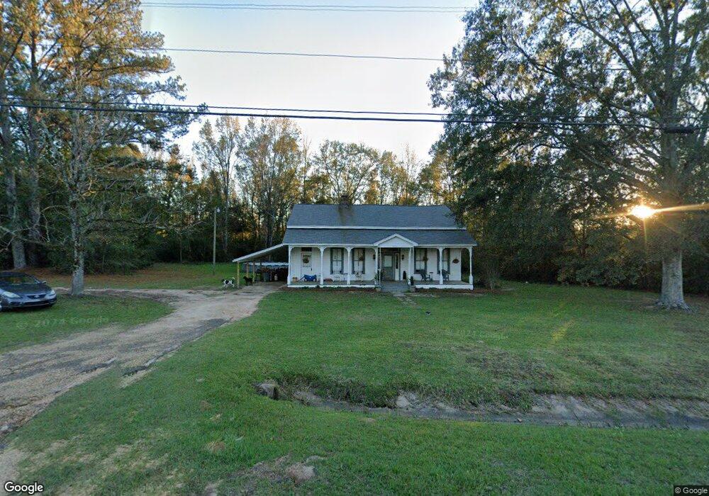
5450 Highway 18 Brandon, MS 39042
Estimated Value: $212,088 - $428,000
3
Beds
1
Bath
2,686
Sq Ft
$109/Sq Ft
Est. Value
About This Home
This home is located at 5450 Highway 18, Brandon, MS 39042 and is currently estimated at $292,272, approximately $108 per square foot. 5450 Highway 18 is a home located in Rankin County with nearby schools including Puckett Elementary School and Puckett High School.
Ownership History
Date
Name
Owned For
Owner Type
Purchase Details
Closed on
Aug 8, 2018
Sold by
Luke Randy L and Luke Mildred N
Bought by
Lifer Michael S and Lifer Bridgette E
Current Estimated Value
Home Financials for this Owner
Home Financials are based on the most recent Mortgage that was taken out on this home.
Original Mortgage
$87,287
Outstanding Balance
$75,647
Interest Rate
4.5%
Mortgage Type
New Conventional
Estimated Equity
$216,625
Purchase Details
Closed on
Feb 19, 2010
Sold by
Lamar Edgar Lamar Edgar and Cox Lonnie H
Bought by
Luke Randy Lavon and Luke Mildred Nicole
Create a Home Valuation Report for This Property
The Home Valuation Report is an in-depth analysis detailing your home's value as well as a comparison with similar homes in the area
Home Values in the Area
Average Home Value in this Area
Purchase History
| Date | Buyer | Sale Price | Title Company |
|---|---|---|---|
| Lifer Michael S | -- | -- | |
| Luke Randy Lavon | -- | -- |
Source: Public Records
Mortgage History
| Date | Status | Borrower | Loan Amount |
|---|---|---|---|
| Open | Lifer Michael S | $87,287 |
Source: Public Records
Tax History Compared to Growth
Tax History
| Year | Tax Paid | Tax Assessment Tax Assessment Total Assessment is a certain percentage of the fair market value that is determined by local assessors to be the total taxable value of land and additions on the property. | Land | Improvement |
|---|---|---|---|---|
| 2024 | $823 | $11,379 | $0 | $0 |
| 2023 | $252 | $4,372 | $0 | $0 |
| 2022 | $245 | $4,372 | $0 | $0 |
| 2021 | $238 | $4,172 | $0 | $0 |
| 2020 | $608 | $6,258 | $0 | $0 |
| 2019 | $553 | $5,529 | $0 | $0 |
| 2018 | $542 | $5,529 | $0 | $0 |
| 2017 | $542 | $5,529 | $0 | $0 |
| 2016 | $530 | $5,696 | $0 | $0 |
| 2015 | $530 | $5,696 | $0 | $0 |
| 2014 | $264 | $5,696 | $0 | $0 |
| 2013 | $264 | $5,696 | $0 | $0 |
Source: Public Records
Map
Nearby Homes
- Johns Shilow Rd
- 0 Ashley Rd Unit 25129785
- 0 Ashley Rd Unit 4128194
- 0 Ashley Rd Unit 4128192
- 0 Ashley Rd Unit 20288528
- 1314 Ashley Rd
- 00 Ashley Rd
- 0 Tullos Cove
- 429 Rose Hill Rd
- 329 County Line Rd
- 00 Johns Shiloh Rd
- 797 County Line Rd
- 410 Cole Rd
- 127 Ole Magnolia Dr
- 0 Easy St
- 0 County Line Rd Unit 4123067
- 235 Woodrow Martin Rd
- 110 Hawks Nest Cove
- 4167 Highway 18
- 2072 Quail Hill Rd
- 5464 Highway 18
- 0 Big Buck Ridge Rd Unit Lot 22 197461
- 1 Big Buck Ridge Rd Unit LOT 22/PARTIAL
- 0 Big Buck Ridge Rd Unit LOT 22/PARTIAL
- 2 Big Buck Ridge Rd Unit 2
- 0 Big Buck Ridge Rd Unit 1 216690
- 0 Sunrise Dr Unit 222795
- 0 Big Buck Ridge Rd Unit 1181894
- 0 Big Buck Ridge Rd Unit Lot 22 1197461
- 0 Big Buck Ridge Rd Unit 1 1216690
- 0 Big Buck Ridge Rd Unit 1157916
- 0 Big Buck Ridge Rd Unit 1197461
- 1 Big Buck Ridge Rd
- 0 Big Buck Ridge Rd Unit 1199140
- 2 Big Buck Ridge Rd
- 0 Sunrise Dr Unit 1222795
- 5472 Highway 18
- 5465 Highway 18
- 417 Gill Rd
- 423 Gill Rd