
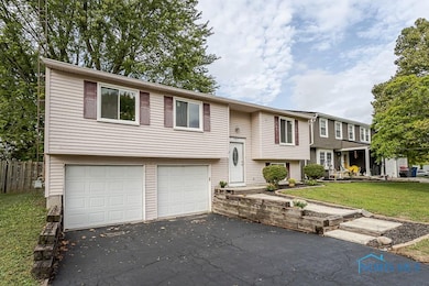


5457 Thornbrook Trail Toledo, OH 43611
Shoreland NeighborhoodEstimated payment $1,323/month
Highlights
- Deck
- Forced Air Heating and Cooling System
- Carpet
- Shed
- 2 Car Garage
About This Home
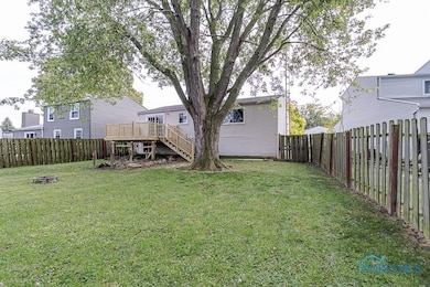
Move-in ready and beautifully renovated! This 3-Bed, 1.5 Bath home in the desirable WLS District offers peace of mind with major improvements including a New Roof (2025), Deck (2025), Carpet & Paint (2025), Tankless Water Heater (2023), A/C (2024). Windows were replaced in 2010 and the driveway has been freshly sealed. The kitchen shines with never used brand new SS appliances, while the bathrooms feature modern touches including a new shower surround. Step outside to the brand-new deck with a fenced-in yard, perfect for relaxing and entertaining. Schedule your showing today!
Home Details
Home Type
- Single Family
Est. Annual Taxes
- $1,673
Year Built
- Built in 1978
Lot Details
- 7,405 Sq Ft Lot
- Lot Dimensions are 47x132
Parking
- 2 Car Garage
- Garage Door Opener
- Driveway
Home Design
- Slab Foundation
- Shingle Roof
- Aluminum Siding
- Steel Siding
Interior Spaces
- 1,506 Sq Ft Home
- 2-Story Property
- Carpet
- Laundry on main level
Kitchen
- Microwave
- Dishwasher
Bedrooms and Bathrooms
- 3 Bedrooms
Outdoor Features
- Deck
- Shed
Schools
- Shoreland Elementary School
- Whitmer High School
Utilities
- Forced Air Heating and Cooling System
- Heating System Uses Natural Gas
- Water Heater
Community Details
- Brook Point Subdivision
Listing and Financial Details
- Assessor Parcel Number 22-88287
Map
Home Values in the Area
Average Home Value in this Area
Tax History
| Year | Tax Paid | Tax Assessment Tax Assessment Total Assessment is a certain percentage of the fair market value that is determined by local assessors to be the total taxable value of land and additions on the property. | Land | Improvement |
|---|---|---|---|---|
| 2024 | $1,673 | $55,160 | $10,360 | $44,800 |
| 2023 | $2,980 | $41,825 | $7,455 | $34,370 |
| 2022 | $2,968 | $41,825 | $7,455 | $34,370 |
| 2021 | $3,033 | $41,825 | $7,455 | $34,370 |
| 2020 | $2,887 | $34,335 | $6,125 | $28,210 |
| 2019 | $2,813 | $34,335 | $6,125 | $28,210 |
| 2018 | $2,521 | $34,335 | $6,125 | $28,210 |
| 2017 | $2,497 | $31,185 | $7,805 | $23,380 |
| 2016 | $2,487 | $89,100 | $22,300 | $66,800 |
| 2015 | $2,478 | $89,100 | $22,300 | $66,800 |
| 2014 | $2,125 | $31,190 | $7,810 | $23,380 |
| 2013 | $2,125 | $31,190 | $7,810 | $23,380 |
Property History
| Date | Event | Price | List to Sale | Price per Sq Ft |
|---|---|---|---|---|
| 10/16/2025 10/16/25 | Price Changed | $224,900 | -4.3% | $149 / Sq Ft |
| 09/26/2025 09/26/25 | For Sale | $235,000 | -- | $156 / Sq Ft |
Purchase History
| Date | Type | Sale Price | Title Company |
|---|---|---|---|
| Warranty Deed | $105,000 | Northwest Title Agency Of Oh | |
| Warranty Deed | $71,000 | -- |
Mortgage History
| Date | Status | Loan Amount | Loan Type |
|---|---|---|---|
| Open | $107,100 | VA |
Source: Northwest Ohio Real Estate Information Service (NORIS)
MLS Number: 6136166
APN: 22-88287
Disclaimer: Certain information contained herein is derived from information provided by parties other than Homes.com. All information provided is deemed reliable, but is not guaranteed to be accurate and should be independently verified.
![]() IDX information is provided exclusively for personal, non-commercial use, and may not be used for any purpose other than to identify prospective properties consumers may be interested in purchasing. Information is deemed reliable but not guaranteed. ©2025 NORIS. All rights reserved.
IDX information is provided exclusively for personal, non-commercial use, and may not be used for any purpose other than to identify prospective properties consumers may be interested in purchasing. Information is deemed reliable but not guaranteed. ©2025 NORIS. All rights reserved.
- 5454 Brook Point Rd
- 5534 Suder Ave
- 5504 Ketukkee Trail
- 2211 E Harbor Dr
- 5433 Brophy Dr
- 5331 Whitehouse Dr
- 5516 Fortune Dr
- 2240 Ruthanne Dr
- 5346 Patriot Dr
- 4828 287th St
- 2441 Point Pleasant Way
- 2642 124th St
- 5531 Ottawa River Rd
- 2641 117th St
- 6233 Grandview Dr
- 2150 Hoops Dr
- 4492 283rd St
- 4811 298th St
- 2827 126th St
- 2826 121st St
- 5148 Suder Ave
- 4901 Suder Ave
- 2830 131st St
- 4493 290th St
- 3563 E Manhattan Blvd
- 3408 E Manhattan Blvd Unit B
- 5311 N Detroit Ave
- 3061.5 Chase St Unit 3061.5 chase St. (upstairs)
- 1019 Booth Ave
- 2529 N Erie St
- 540 W Alexis Rd
- 4442 Caroline Ave
- 902 Gribbin Ln
- 6210 Lewis Ave
- 3962 Woodhaven Dr
- 4044 Asbury Dr
- 1221 Peck St
