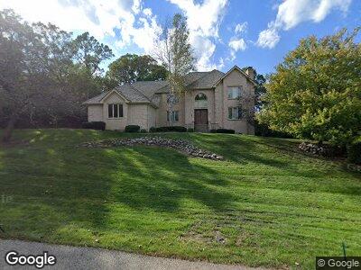
5459 N Tall Oaks Dr Unit 3 Long Grove, IL 60047
Estimated Value: $931,000 - $1,123,000
5
Beds
5
Baths
4,179
Sq Ft
$242/Sq Ft
Est. Value
About This Home
This home is located at 5459 N Tall Oaks Dr Unit 3, Long Grove, IL 60047 and is currently estimated at $1,012,874, approximately $242 per square foot. 5459 N Tall Oaks Dr Unit 3 is a home located in Lake County with nearby schools including Country Meadows Elementary School, Woodlawn Middle School, and Adlai E Stevenson High School.
Ownership History
Date
Name
Owned For
Owner Type
Purchase Details
Closed on
Jul 29, 2011
Sold by
Bardenstein Leonid and Bardenstein Rami
Bought by
Bardenstein Leonid
Current Estimated Value
Home Financials for this Owner
Home Financials are based on the most recent Mortgage that was taken out on this home.
Original Mortgage
$410,000
Interest Rate
4.32%
Mortgage Type
New Conventional
Purchase Details
Closed on
Dec 13, 2010
Sold by
Wells Fargo Bank N A
Bought by
Bardenstein Leonid and Bardenstein Rami
Home Financials for this Owner
Home Financials are based on the most recent Mortgage that was taken out on this home.
Original Mortgage
$414,100
Interest Rate
5.25%
Mortgage Type
FHA
Purchase Details
Closed on
Jul 6, 2010
Sold by
Dubovici Simona and Case 09 Ch 01181
Bought by
Wells Fargo Bank Na
Purchase Details
Closed on
May 5, 2005
Sold by
Daniels Joseph and Daniels Rhonda
Bought by
Dubovici Simona
Home Financials for this Owner
Home Financials are based on the most recent Mortgage that was taken out on this home.
Original Mortgage
$640,000
Interest Rate
1.75%
Mortgage Type
Negative Amortization
Purchase Details
Closed on
Feb 27, 1998
Sold by
Chaudry Muhammad Munir and Rahim Ejaz
Bought by
Daniels Joseph and Daniels Rhonda
Home Financials for this Owner
Home Financials are based on the most recent Mortgage that was taken out on this home.
Original Mortgage
$300,000
Interest Rate
6.75%
Purchase Details
Closed on
Feb 7, 1996
Sold by
Armstrong R L Trace and Armstrong Tami F
Bought by
Rahim Ejaz and Chaudry Muhammad Munir
Home Financials for this Owner
Home Financials are based on the most recent Mortgage that was taken out on this home.
Original Mortgage
$459,000
Interest Rate
7.5%
Create a Home Valuation Report for This Property
The Home Valuation Report is an in-depth analysis detailing your home's value as well as a comparison with similar homes in the area
Home Values in the Area
Average Home Value in this Area
Purchase History
| Date | Buyer | Sale Price | Title Company |
|---|---|---|---|
| Bardenstein Leonid | -- | Cambridge Title Company | |
| Bardenstein Leonid | $441,000 | Forum Title Insurance Co | |
| Wells Fargo Bank Na | -- | None Available | |
| Dubovici Simona | $800,000 | Ticor | |
| Daniels Joseph | $543,000 | -- | |
| Rahim Ejaz | $541,000 | Republic Title Company |
Source: Public Records
Mortgage History
| Date | Status | Borrower | Loan Amount |
|---|---|---|---|
| Open | Bardenstein Leonid | $79,400 | |
| Open | Bardenstein Leonid | $397,000 | |
| Closed | Bardenstein Leonid | $402,800 | |
| Closed | Bardenstein Leonid | $407,000 | |
| Closed | Bardenstein Leonid | $410,000 | |
| Previous Owner | Bardenstein Leonid | $414,100 | |
| Previous Owner | Dubovici Simona | $800,000 | |
| Previous Owner | Dubovici Simona | $640,000 | |
| Previous Owner | Daniels Joseph | $250,000 | |
| Previous Owner | Daniels Joseph | $200,000 | |
| Previous Owner | Daniels Joseph | $286,700 | |
| Previous Owner | Daniels Joseph | $300,000 | |
| Previous Owner | Rahim Ejaz | $459,000 |
Source: Public Records
Tax History Compared to Growth
Tax History
| Year | Tax Paid | Tax Assessment Tax Assessment Total Assessment is a certain percentage of the fair market value that is determined by local assessors to be the total taxable value of land and additions on the property. | Land | Improvement |
|---|---|---|---|---|
| 2024 | $23,804 | $280,895 | $53,764 | $227,131 |
| 2023 | $19,790 | $259,848 | $49,735 | $210,113 |
| 2022 | $19,790 | $215,699 | $41,285 | $174,414 |
| 2021 | $19,108 | $213,373 | $40,840 | $172,533 |
| 2020 | $18,689 | $214,101 | $40,979 | $173,122 |
| 2019 | $18,177 | $213,312 | $40,828 | $172,484 |
| 2018 | $18,337 | $232,449 | $44,381 | $188,068 |
| 2017 | $18,918 | $227,023 | $43,345 | $183,678 |
| 2016 | $19,581 | $244,068 | $41,506 | $202,562 |
| 2015 | $20,138 | $237,904 | $38,816 | $199,088 |
| 2014 | $12,438 | $141,572 | $41,688 | $99,884 |
| 2012 | $12,048 | $141,856 | $41,772 | $100,084 |
Source: Public Records
Map
Nearby Homes
- 5632 Oakwood Cir
- 4864 Pond View Ct
- 6248 Pine Tree Dr
- 4739 Wellington Dr
- 6245 Pine Tree Dr
- 4722 Wellington Dr
- 4726 Westbury Dr
- 6421 Collier Cir
- 4610 Forest Way Cir Unit 4
- 4523 Red Oak Ln
- 5538 Prairiemoor Ln
- 239 W Ct of Shorewood Unit 3A
- 306 Richard Ct Unit 3
- 5364 Hedgewood Ct
- 109 Thorne Grove Dr
- 900 N Lakeside Dr Unit 1D
- 312 Cherry Valley Rd
- 405 Cherry Valley Rd
- 1995 Wilshire Ct
- 6517 Saddle Ridge Ct
- 5459 N Tall Oaks Dr Unit 3
- 5460 Port Clinton Rd
- 5457 N Tall Oaks Dr
- 5462 N Tall Oaks Dr
- 5600 Black Walnut Trail
- 5455 High Point Ct
- 5602 Black Walnut Trail
- 5464 Port Clinton Rd
- 5453 High Point Ct
- 5456 N Tall Oaks Dr Unit 3
- 5604 Black Walnut Trail Unit 4
- 5465 Port Clinton Rd
- 5606 Black Walnut Trail Unit 1A
- 5608 Black Walnut Trail
- 5601 Black Walnut Trail
- 5466 Port Clinton Rd
- 5454 N Tall Oaks Dr
- 5603 Black Walnut Trail Unit 4
- 5610 Black Walnut Trail
- 5468 Port Clinton Rd