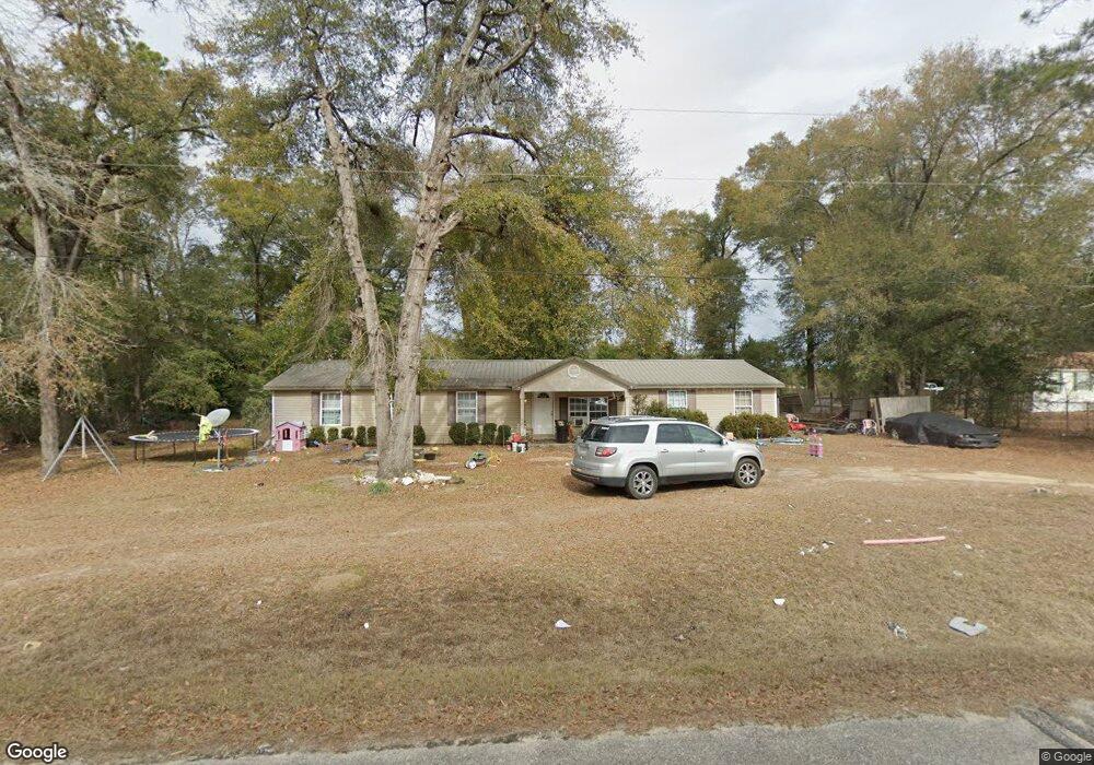
546 Flint River Heights Rd Bainbridge, GA 39817
Estimated Value: $122,000 - $224,000
--
Bed
1
Bath
1,924
Sq Ft
$96/Sq Ft
Est. Value
About This Home
This home is located at 546 Flint River Heights Rd, Bainbridge, GA 39817 and is currently estimated at $184,429, approximately $95 per square foot. 546 Flint River Heights Rd is a home located in Decatur County with nearby schools including Bainbridge High School.
Ownership History
Date
Name
Owned For
Owner Type
Purchase Details
Closed on
Oct 2, 2015
Sold by
Brinson Roy Thomas
Bought by
Feagle William R and Chinell Lisa
Current Estimated Value
Home Financials for this Owner
Home Financials are based on the most recent Mortgage that was taken out on this home.
Original Mortgage
$55,000
Outstanding Balance
$21,617
Interest Rate
3.16%
Mortgage Type
New Conventional
Estimated Equity
$162,812
Purchase Details
Closed on
May 28, 2014
Sold by
Alday James Bryan
Bought by
Brinson Roy Thomas and Brinson Maggie M
Purchase Details
Closed on
May 2, 2007
Sold by
Brinson Roy Thomas
Bought by
Alday James Bryan and Alday Misti Fay
Home Financials for this Owner
Home Financials are based on the most recent Mortgage that was taken out on this home.
Original Mortgage
$95,000
Interest Rate
6.12%
Mortgage Type
New Conventional
Create a Home Valuation Report for This Property
The Home Valuation Report is an in-depth analysis detailing your home's value as well as a comparison with similar homes in the area
Home Values in the Area
Average Home Value in this Area
Purchase History
| Date | Buyer | Sale Price | Title Company |
|---|---|---|---|
| Feagle William R | $60,000 | -- | |
| Brinson Roy Thomas | $79,768 | -- | |
| Alday James Bryan | $97,000 | -- |
Source: Public Records
Mortgage History
| Date | Status | Borrower | Loan Amount |
|---|---|---|---|
| Open | Feagle William R | $55,000 | |
| Previous Owner | Alday James Bryan | $95,000 |
Source: Public Records
Tax History Compared to Growth
Tax History
| Year | Tax Paid | Tax Assessment Tax Assessment Total Assessment is a certain percentage of the fair market value that is determined by local assessors to be the total taxable value of land and additions on the property. | Land | Improvement |
|---|---|---|---|---|
| 2024 | $1,506 | $50,014 | $3,600 | $46,414 |
| 2023 | $1,506 | $50,014 | $3,600 | $46,414 |
| 2022 | $1,456 | $50,024 | $3,600 | $46,424 |
| 2021 | $1,303 | $43,969 | $3,600 | $40,369 |
| 2020 | $1,152 | $38,874 | $3,600 | $35,274 |
| 2019 | $883 | $29,226 | $3,600 | $25,626 |
| 2018 | $872 | $29,226 | $3,600 | $25,626 |
| 2017 | $917 | $29,226 | $3,600 | $25,626 |
| 2016 | $690 | $29,226 | $3,600 | $25,626 |
| 2015 | $1,015 | $24,000 | $2,708 | $21,292 |
| 2014 | $830 | $31,907 | $3,600 | $28,307 |
| 2013 | -- | $31,907 | $3,600 | $28,307 |
Source: Public Records
Map
Nearby Homes
- 533 Flint River Heights Rd
- 757 Manhole Rd
- 00 Manhole Rd
- 116 Flint River Heights Rd
- 104 Brock St
- 186 Aryola Dr
- 2137 Pondtown Rd
- Tract 1 Rivervale Dr
- 150 Rivervale Dr
- 160 Manhole Rd
- 116 Rivervale Dr
- 0 Pine St Unit 10993
- 287 Cloverleaf Cir
- 3236 Vada Rd
- 2036 Lexington Ave
- 2032 Lexington Ave
- 000 E River Rd
- 0 Newton Rd
- 1302 Majestic Ave
- 1606 Hemlock St
- 2014 Newton Rd
- 545 Flint River Heights Rd
- 2010 Newton Rd
- 123 River Front Rd
- 2000 Newton Rd
- 133 River Front Rd
- 525 Flint River Heights Rd
- 1994 Newton Rd
- 523 Flint River Heights Rd
- 138 River Front Rd
- 483 Flint River Heights Rd
- 508 Flint River Heights Rd
- 504 Flint River Heights Rd
- 498 Flint River Heights Rd
- 479 Flint River Heights Rd
- 486 Flint River Heights Rd
- 727 Manhole Rd
- 751 Manhole Rd
- 468 Flint River Heights Rd
- 719 Manhole Rd