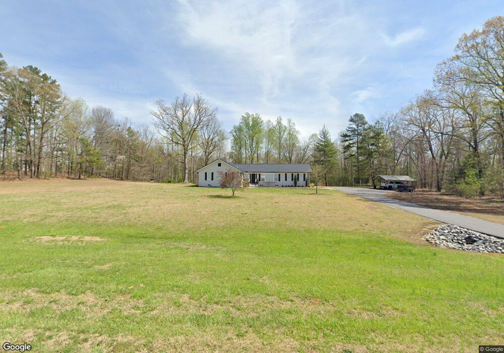
5482 N Highway 11 Walhalla, SC 29691
Estimated Value: $134,000 - $312,212
3
Beds
2
Baths
2,192
Sq Ft
$96/Sq Ft
Est. Value
About This Home
This home is located at 5482 N Highway 11, Walhalla, SC 29691 and is currently estimated at $211,053, approximately $96 per square foot. 5482 N Highway 11 is a home located in Oconee County with nearby schools including Walhalla Elementary School, Walhalla Middle School, and Walhalla High School.
Ownership History
Date
Name
Owned For
Owner Type
Purchase Details
Closed on
Jan 3, 2022
Sold by
Reid Hubbard Patsy
Bought by
Poore Bradley Wayne
Current Estimated Value
Purchase Details
Closed on
Jun 19, 2012
Sold by
Hubbard David G
Bought by
Hubbard Reese Algin and Hubbard Patsy Reid
Purchase Details
Closed on
Apr 24, 2012
Sold by
Hubbard Gail D
Bought by
Hubbard David G and Hubbard Gail Dickie
Purchase Details
Closed on
Feb 3, 2010
Sold by
The Bank Of New York Mellon
Bought by
Hubbard Gail D and Hubbard David G
Purchase Details
Closed on
Nov 17, 2009
Sold by
Jerema Joseph R and Jarema Judith G
Bought by
The Bank Of New York Mellon and The Bank Of New York
Create a Home Valuation Report for This Property
The Home Valuation Report is an in-depth analysis detailing your home's value as well as a comparison with similar homes in the area
Home Values in the Area
Average Home Value in this Area
Purchase History
| Date | Buyer | Sale Price | Title Company |
|---|---|---|---|
| Poore Bradley Wayne | -- | None Listed On Document | |
| Hubbard Reese Algin | $75,000 | -- | |
| Hubbard David G | -- | -- | |
| Hubbard Gail D | $49,000 | -- | |
| The Bank Of New York Mellon | $98,600 | -- |
Source: Public Records
Tax History
| Year | Tax Paid | Tax Assessment Tax Assessment Total Assessment is a certain percentage of the fair market value that is determined by local assessors to be the total taxable value of land and additions on the property. | Land | Improvement |
|---|---|---|---|---|
| 2025 | $636 | $6,058 | $2,275 | $3,783 |
| 2024 | $636 | $6,058 | $2,275 | $3,783 |
| 2023 | $644 | $6,058 | $2,275 | $3,783 |
| 2022 | $1,432 | $5,036 | $1,253 | $3,783 |
| 2021 | $1,346 | $4,599 | $1,023 | $3,576 |
| 2020 | $1,346 | $0 | $0 | $0 |
| 2019 | $1,346 | $0 | $0 | $0 |
| 2018 | $1,311 | $0 | $0 | $0 |
| 2017 | $1,572 | $0 | $0 | $0 |
| 2016 | $1,572 | $0 | $0 | $0 |
| 2015 | -- | $0 | $0 | $0 |
| 2014 | -- | $8,633 | $2,247 | $6,387 |
| 2013 | -- | $0 | $0 | $0 |
Source: Public Records
Map
Nearby Homes
- 408 Falcons Lair West Dr
- 525 Sixteenth Cir
- 533 Sixteenth Cir
- 1515 Hendon Dr
- 00 Lecroy Rd
- 857 Pickett Post Rd
- Hudson Plan at Windsor Estates
- Bramante Ranch Plan at Windsor Estates
- Savannah Plan at Windsor Estates
- Columbia Plan at Windsor Estates
- Cumberland Plan at Windsor Estates
- Cumberland with Basement Plan at Windsor Estates
- 1817 Hastehill Dr
- 2009 Aberdeen Ln
- 310 Falcons Nest Rd
- 505 Hillside Dr
- 00 Oconee Creek Rd
- 00 Oconee Station Rd
- 0A Oconee Station Rd
- 00 Heaven View Dr
- 5542 N Highway 11
- 421 Falcons Lair West Dr
- 437 Falcons Lair Dr W
- 140 Lecroy Rd
- 8 Lecroy Rd
- 10 Lecroy Rd
- 408 Falcons Lair Dr W
- 117 Lecroy Rd
- 1750 Vaughn Hollows Dr
- 144 Lecroy Rd
- 553 Sixteenth Cir
- 125 Lecroy Rd
- 504 Sixteenth Cir
- 185 Lecroy Rd
- 5744 N Highway 11
- Lot 3-39 Falcons Lair Dr W
- Lot 16 Falcons Lair Dr W
- 136 Lecroy Rd
- 1606 Lily Ln
- Lot # Falcons Lair Dr W
Your Personal Tour Guide
Ask me questions while you tour the home.