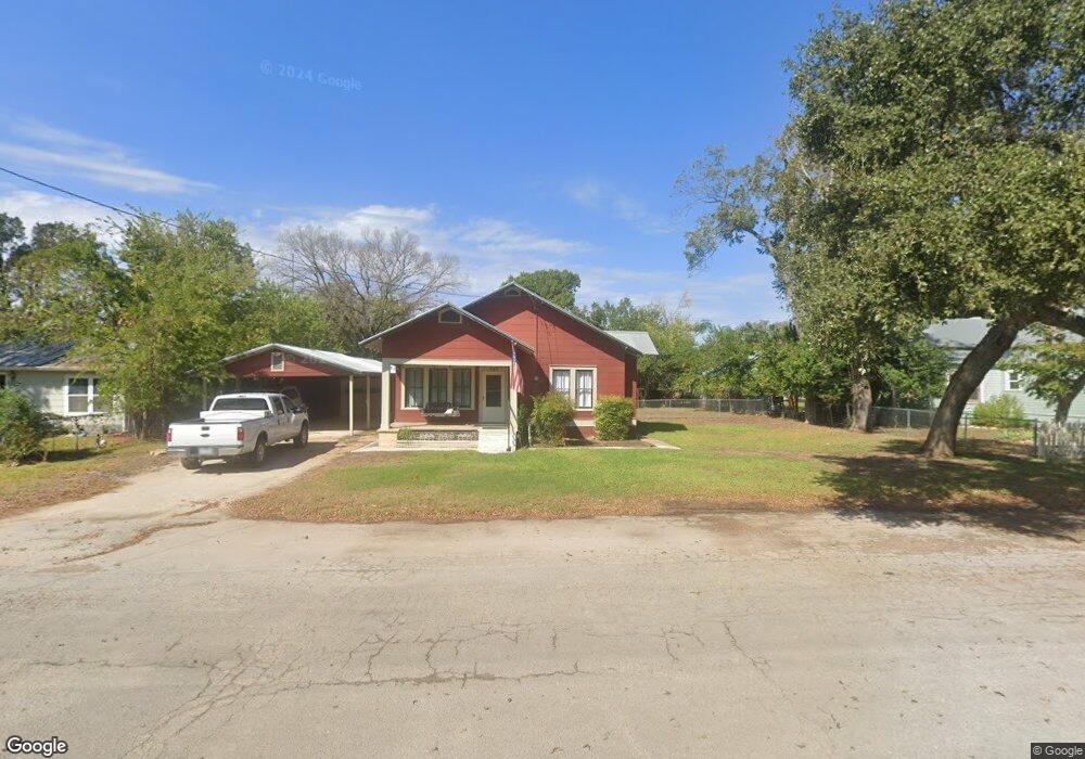
549 E Camp St New Braunfels, TX 78130
Estimated Value: $380,000 - $415,483
--
Bed
1
Bath
1,000
Sq Ft
$398/Sq Ft
Est. Value
About This Home
This home is located at 549 E Camp St, New Braunfels, TX 78130 and is currently estimated at $397,742, approximately $397 per square foot. 549 E Camp St is a home located in Comal County with nearby schools including Oak Run Middle School, New Braunfels High School, and New Braunfels High School Ninth Grade Center.
Ownership History
Date
Name
Owned For
Owner Type
Purchase Details
Closed on
Sep 11, 2017
Sold by
Orange Lake Country Club Inc
Bought by
Brown Marie A
Current Estimated Value
Home Financials for this Owner
Home Financials are based on the most recent Mortgage that was taken out on this home.
Original Mortgage
$8,273
Outstanding Balance
$6,886
Interest Rate
3.78%
Estimated Equity
$390,856
Purchase Details
Closed on
Apr 5, 2017
Sold by
Herrera Maria and Lamb Robert Lamb
Bought by
Silverleaf Resorts Inc
Home Financials for this Owner
Home Financials are based on the most recent Mortgage that was taken out on this home.
Interest Rate
4.14%
Create a Home Valuation Report for This Property
The Home Valuation Report is an in-depth analysis detailing your home's value as well as a comparison with similar homes in the area
Home Values in the Area
Average Home Value in this Area
Purchase History
| Date | Buyer | Sale Price | Title Company |
|---|---|---|---|
| Brown Marie A | $9,700 | -- | |
| Silverleaf Resorts Inc | -- | -- |
Source: Public Records
Mortgage History
| Date | Status | Borrower | Loan Amount |
|---|---|---|---|
| Open | Brown Marie A | $8,273 | |
| Closed | Brown Marie A | -- | |
| Previous Owner | Silverleaf Resorts Inc | -- |
Source: Public Records
Tax History Compared to Growth
Tax History
| Year | Tax Paid | Tax Assessment Tax Assessment Total Assessment is a certain percentage of the fair market value that is determined by local assessors to be the total taxable value of land and additions on the property. | Land | Improvement |
|---|---|---|---|---|
| 2025 | $6,223 | $370,400 | $216,440 | $153,960 |
| 2024 | $6,223 | $368,950 | $216,440 | $152,510 |
| 2023 | $6,223 | $346,220 | $216,440 | $129,780 |
| 2022 | $6,279 | $331,500 | $216,440 | $115,060 |
| 2021 | $5,789 | $280,360 | $176,400 | $103,960 |
| 2020 | $5,437 | $251,500 | $147,000 | $104,500 |
| 2019 | $4,422 | $199,900 | $79,100 | $120,800 |
| 2018 | $3,857 | $176,490 | $79,100 | $97,390 |
| 2017 | $3,994 | $183,180 | $79,100 | $104,080 |
| 2016 | $3,219 | $147,660 | $50,680 | $96,980 |
| 2015 | $496 | $135,510 | $50,680 | $84,830 |
| 2014 | $496 | $130,020 | $50,680 | $79,340 |
Source: Public Records
Map
Nearby Homes
- 761 Heartseed Ave
- 664 E North St
- 342 E Camp St
- 481 N Central Ave
- 305 Bow Crossing
- 540 E South St
- 571 N Houston Ave
- 486 E South St
- 594 E South St
- 1106 Hillcrest Dr
- 640 N Houston Ave
- 717 Dittlinger St
- 747 Dittlinger St
- 242 E Austin St
- 587 E Basel St Unit 4
- 587 E Basel St
- 257 Dittlinger St
- 683 Albert St
- 565 E Basel St Unit 1
- 565 E Basel St
- 515 E Camp St
- 581 E Camp St
- 507 E Camp St
- 468 N Veramendi Ave
- 499 N Grant Ave
- 554 E North St
- 492 N Veramendi Ave
- 560 E Camp St
- 390 N Veramendi Ave
- 588 E Camp St
- 621 E Camp St
- 460 N Grant Ave
- 635 E Camp St
- 473 N Veramendi Ave
- 491 N Veramendi Ave
- 462 E North St
- 628 E North St
- 395 N Veramendi Ave
- 643 E Camp St
- 461 E Camp St