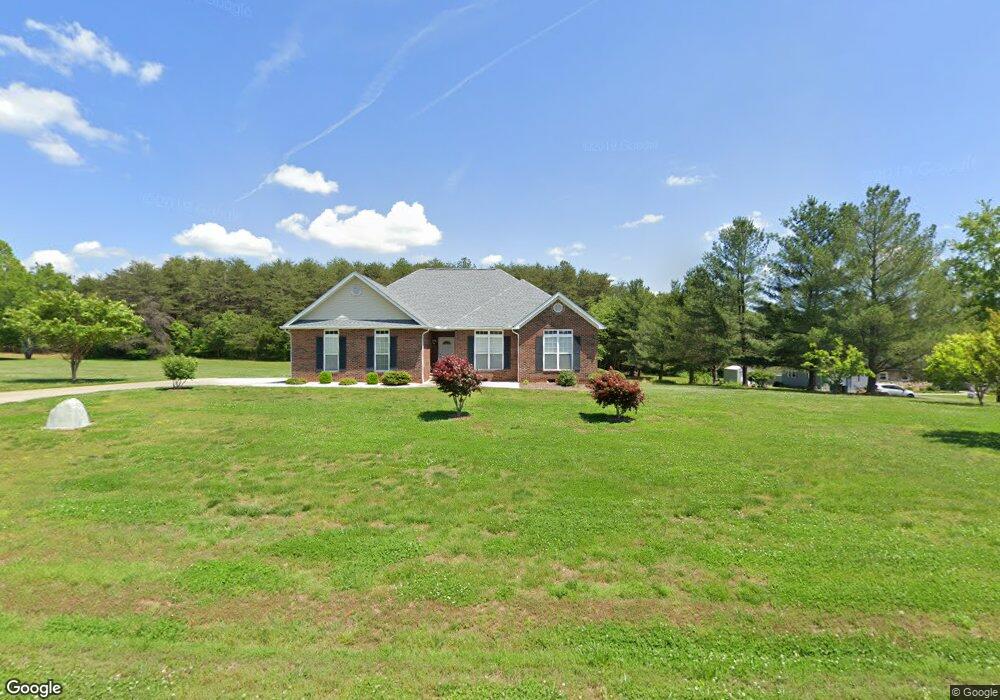
5490 Swinging Bridge Rd Conover, NC 28613
Estimated Value: $285,000 - $462,826
3
Beds
2
Baths
1,877
Sq Ft
$185/Sq Ft
Est. Value
About This Home
This home is located at 5490 Swinging Bridge Rd, Conover, NC 28613 and is currently estimated at $347,457, approximately $185 per square foot. 5490 Swinging Bridge Rd is a home located in Catawba County with nearby schools including Oxford Elementary School, River Bend Middle School, and Bunker Hill High School.
Ownership History
Date
Name
Owned For
Owner Type
Purchase Details
Closed on
Apr 11, 2005
Sold by
Vang Chia and Vang Yer
Bought by
Yang Bee Lao and Yang Youa Vang
Current Estimated Value
Home Financials for this Owner
Home Financials are based on the most recent Mortgage that was taken out on this home.
Original Mortgage
$43,866
Interest Rate
5.7%
Mortgage Type
Fannie Mae Freddie Mac
Create a Home Valuation Report for This Property
The Home Valuation Report is an in-depth analysis detailing your home's value as well as a comparison with similar homes in the area
Home Values in the Area
Average Home Value in this Area
Purchase History
| Date | Buyer | Sale Price | Title Company |
|---|---|---|---|
| Yang Bee Lao | $49,000 | None Available |
Source: Public Records
Mortgage History
| Date | Status | Borrower | Loan Amount |
|---|---|---|---|
| Previous Owner | Yang Bee Lao | $43,866 |
Source: Public Records
Tax History Compared to Growth
Tax History
| Year | Tax Paid | Tax Assessment Tax Assessment Total Assessment is a certain percentage of the fair market value that is determined by local assessors to be the total taxable value of land and additions on the property. | Land | Improvement |
|---|---|---|---|---|
| 2025 | $1,612 | $350,800 | $34,600 | $316,200 |
| 2024 | $1,612 | $350,800 | $34,600 | $316,200 |
| 2023 | $1,612 | $237,500 | $34,600 | $202,900 |
| 2022 | $1,520 | $237,500 | $34,600 | $202,900 |
| 2021 | $1,520 | $237,500 | $34,600 | $202,900 |
| 2020 | $1,520 | $237,500 | $34,600 | $202,900 |
| 2019 | $1,520 | $237,500 | $0 | $0 |
| 2018 | $1,343 | $209,800 | $34,200 | $175,600 |
| 2017 | $1,343 | $0 | $0 | $0 |
| 2016 | $1,343 | $0 | $0 | $0 |
| 2015 | $1,391 | $209,760 | $34,200 | $175,560 |
| 2014 | $1,391 | $237,400 | $38,100 | $199,300 |
Source: Public Records
Map
Nearby Homes
- 2270 Houston Mill Rd
- 4786 Thoreau Dr
- 4774 Thoreau Dr
- 28.8 Acres +/- Carver House Rd
- 25 Acres+/- Carver House Rd
- 5325 N Carolina 16
- 4793 Panama Dr
- 4671 Crystal St
- 5101 Mill Pond Dr
- 2101 Redberry Ln
- 2200 Oweda Dr
- 1862 Green Leaf Ct
- 4932 Sandstone Dr
- 1371 Millrace Dr
- 2488 Compass St
- 4874 Stone Dr Unit 125
- 5826 St Peters Church Rd
- 1805 Edgewater Dr NW
- 4177 Ridge Dr NE Unit 1
- 4551 Holly Cir NE
- 5474 Swinging Bridge Rd
- 5508 Swinging Bridge Rd
- 2077 Waterfall Ln
- 5546 Swinging Bridge Rd
- 5541 Swinging Bridge Rd
- 5541 Swinging Bridge Rd Unit 5
- 5564 Swinging Bridge Rd
- 5395 Swinging Bridge Rd
- 5569 Swinging Bridge Rd
- 5590 Swinging Bridge Rd
- 5589 Swinging Bridge Rd
- 5394 Swinging Bridge Rd
- 5613 Swinging Bridge Rd
- 5653 Swinging Bridge Rd
- 5653 Swinging Bridge Rd Unit 2
- 5646 Swinging Bridge Rd
- 5265 Swinging Bridge Rd
- 5250 Swinging Bridge Rd
- 5660 Swinging Bridge Rd
- 5675 Swinging Bridge Rd