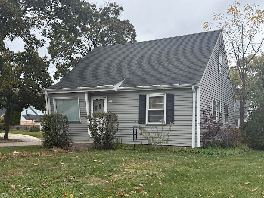


5494 N 12th St Milwaukee, WI 53209
Milwaukee River Parkway NeighborhoodEstimated payment $1,317/month
Highlights
- Cape Cod Architecture
- 1.5 Car Detached Garage
- 3-minute walk to Milwaukee River Parkway
- Walnut Grove Elementary School Rated A
- Forced Air Heating and Cooling System
About This Home
Solid Milwaukee home in a great area. Needs some updating but a great investment considering this desirable Milwaukee neighborhood. Great sized bedrooms and partially finished lower with vintage bar area. Would love to sell before the winter, make an offer!
Home Details
Home Type
- Single Family
Est. Annual Taxes
- $2,542
Lot Details
- 6,098 Sq Ft Lot
Parking
- 1.5 Car Detached Garage
Home Design
- Cape Cod Architecture
- Vinyl Siding
Interior Spaces
- 1,288 Sq Ft Home
- 2-Story Property
- Basement Fills Entire Space Under The House
Kitchen
- Oven
- Range
Bedrooms and Bathrooms
- 4 Bedrooms
- 1 Full Bathroom
Utilities
- Forced Air Heating and Cooling System
- Heating System Uses Natural Gas
Listing and Financial Details
- Exclusions: Washer, dryer. Tenants personal property
- Assessor Parcel Number 1960163000
Map
Home Values in the Area
Average Home Value in this Area
Tax History
| Year | Tax Paid | Tax Assessment Tax Assessment Total Assessment is a certain percentage of the fair market value that is determined by local assessors to be the total taxable value of land and additions on the property. | Land | Improvement |
|---|---|---|---|---|
| 2024 | $2,543 | $114,700 | $4,600 | $110,100 |
| 2023 | $2,273 | $96,200 | $4,600 | $91,600 |
| 2022 | $2,217 | $96,200 | $4,600 | $91,600 |
| 2021 | $2,476 | $96,900 | $4,700 | $92,200 |
| 2020 | $2,461 | $96,900 | $4,700 | $92,200 |
| 2019 | $2,815 | $128,900 | $4,700 | $124,200 |
| 2018 | $3,268 | $128,900 | $4,700 | $124,200 |
| 2017 | $3,445 | $128,900 | $8,000 | $120,900 |
| 2016 | $3,337 | $86,000 | $8,000 | $78,000 |
| 2015 | $3,223 | $117,000 | $8,000 | $109,000 |
| 2014 | $3,515 | $124,500 | $8,000 | $116,500 |
| 2013 | -- | $124,500 | $8,000 | $116,500 |
Property History
| Date | Event | Price | List to Sale | Price per Sq Ft |
|---|---|---|---|---|
| 11/13/2025 11/13/25 | For Sale | $210,000 | -- | $163 / Sq Ft |
Purchase History
| Date | Type | Sale Price | Title Company |
|---|---|---|---|
| Warranty Deed | $86,000 | First American Title |
Mortgage History
| Date | Status | Loan Amount | Loan Type |
|---|---|---|---|
| Previous Owner | $73,100 | New Conventional |
Source: Metro MLS
MLS Number: 1942760
APN: 196-0163-000-4
Disclaimer: Certain information contained herein is derived from information provided by parties other than Homes.com. All information provided is deemed reliable, but is not guaranteed to be accurate and should be independently verified.
![]() IDX information is provided exclusively for personal, non-commercial use, and may not be used for any purpose other than to identify prospective properties consumers may be interested in purchasing.
IDX information is provided exclusively for personal, non-commercial use, and may not be used for any purpose other than to identify prospective properties consumers may be interested in purchasing.
IDX listing data provided by Multiple Listing Service, Inc. Information is supplied by seller and other third parties and has not been verified.
Copyright 2025 – Multiple Listing Service, Inc. – All Rights Reserved.
- 5525 N 12th St
- 1011 W Silver Spring Dr
- 1405 W Custer Ave
- 5230 N Milwaukee River Pkwy
- 1631 W Custer Ave
- 5686 N River Forest Dr
- 1334 W Paradise Ct
- 7216 N Mohawk Ave
- 5564 N Mohawk Ave
- 723 W Riverview Dr
- 305 W Silver Spring Dr
- 5509 N 20th St
- 5810 N Green Bay Ave
- 5405 N Lydell Ave
- 2220 W Neil Place
- 5084 N 20th St
- 5006 N Port Washington Rd
- 2336 W Lawn Ave
- 5607 N Argyle Ave
- 2328 W Rohr Ave
- 1400 W Custer Ave
- 1705 W Custer Ave
- 5400 N Iroquois Ave
- 5699 N Centerpark Way
- 1981 W Villard Ave Unit 7
- 5905 N Lydell Ave
- 1633 W Bender Rd
- 6091 N Green Bay Ave
- 2455 W Silver Spring Dr
- 5457 N Berkeley Blvd
- 1616 W Bender Rd
- 1616 W Bender Rd Unit 213
- 500 W Hampton Ave
- 100-246 E Chateau Place
- 6015 N Shoreland Ave
- 406 E Henry Clay St Unit 4
- 4848 N Lydell Ave
- 4738 N 20th St
- 4918 N Berkeley Blvd
- 5969 N Shore Dr
