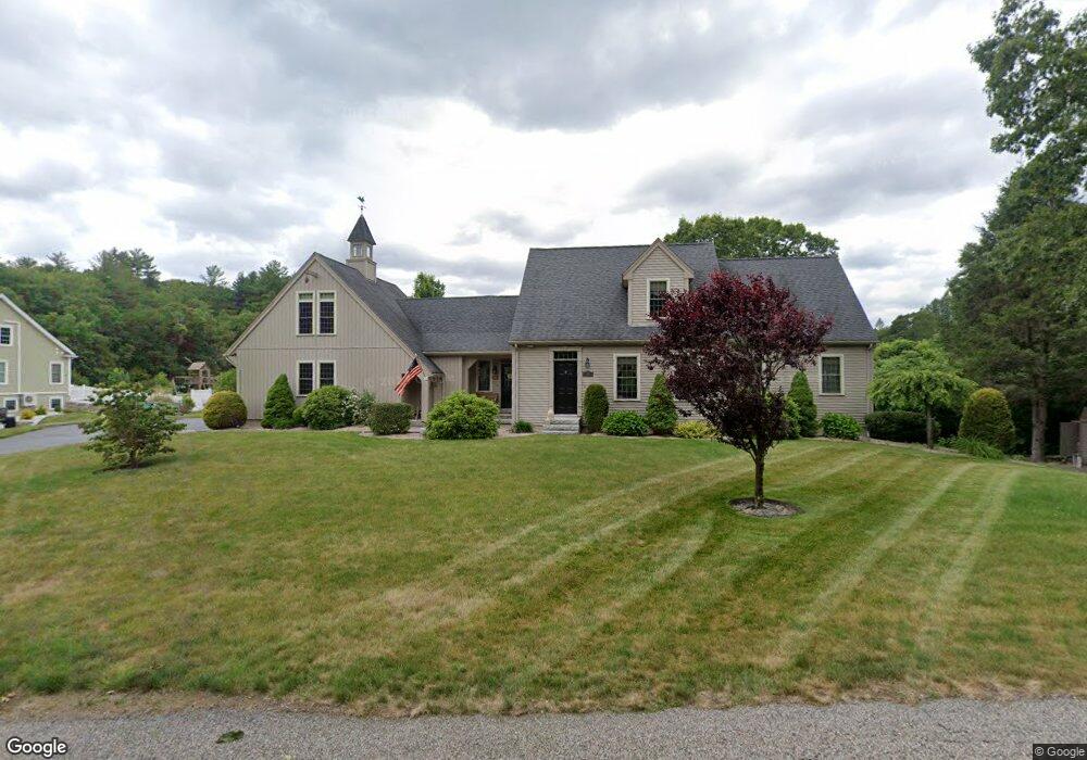
55 Dwinell Rd Millbury, MA 01527
Estimated Value: $668,000 - $901,000
3
Beds
3
Baths
2,614
Sq Ft
$306/Sq Ft
Est. Value
About This Home
This home is located at 55 Dwinell Rd, Millbury, MA 01527 and is currently estimated at $799,859, approximately $305 per square foot. 55 Dwinell Rd is a home with nearby schools including Elmwood Street Elementary School, Raymond E. Shaw Elementary School, and Millbury Junior/Senior High School.
Ownership History
Date
Name
Owned For
Owner Type
Purchase Details
Closed on
Mar 26, 2013
Sold by
Mahan Mary R
Bought by
Mary R Mahan Irt and Mahan Mary R
Current Estimated Value
Purchase Details
Closed on
Jul 10, 2009
Sold by
Allaire Donald G and Allaire Kathy P
Bought by
Mahan John F and Mahan Mary R
Home Financials for this Owner
Home Financials are based on the most recent Mortgage that was taken out on this home.
Original Mortgage
$308,000
Interest Rate
4.93%
Mortgage Type
Purchase Money Mortgage
Create a Home Valuation Report for This Property
The Home Valuation Report is an in-depth analysis detailing your home's value as well as a comparison with similar homes in the area
Home Values in the Area
Average Home Value in this Area
Purchase History
| Date | Buyer | Sale Price | Title Company |
|---|---|---|---|
| Mary R Mahan Irt | -- | -- | |
| Mahan John F | $120,000 | -- |
Source: Public Records
Mortgage History
| Date | Status | Borrower | Loan Amount |
|---|---|---|---|
| Previous Owner | Mahan John F | $308,000 |
Source: Public Records
Tax History Compared to Growth
Tax History
| Year | Tax Paid | Tax Assessment Tax Assessment Total Assessment is a certain percentage of the fair market value that is determined by local assessors to be the total taxable value of land and additions on the property. | Land | Improvement |
|---|---|---|---|---|
| 2025 | $10,587 | $790,700 | $162,900 | $627,800 |
| 2024 | $9,729 | $735,400 | $150,900 | $584,500 |
| 2023 | $8,780 | $607,600 | $101,600 | $506,000 |
| 2022 | $8,550 | $570,000 | $101,600 | $468,400 |
| 2021 | $4,360 | $540,000 | $101,600 | $438,400 |
| 2020 | $8,048 | $525,000 | $101,600 | $423,400 |
| 2019 | $8,991 | $513,500 | $88,400 | $425,100 |
| 2018 | $5,430 | $500,900 | $103,800 | $397,100 |
| 2017 | $7,385 | $449,500 | $103,800 | $345,700 |
| 2016 | $7,290 | $442,900 | $103,800 | $339,100 |
| 2015 | $7,256 | $440,800 | $110,300 | $330,500 |
| 2014 | $7,061 | $412,900 | $106,200 | $306,700 |
Source: Public Records
Map
Nearby Homes
- 33 Tainter Hill Rd Unit 33B
- 14 Auburn Rd
- 5- 33 Tainter Hill Rd Unit 33A
- 5- 33 Tainter Hill Rd
- 557 SW Cutoff Unit 79
- 557 SW Cutoff Unit 107
- 557 SW Cutoff Unit 17
- 0 Auburn Rd
- 47 Washington St Unit 26
- 24 Upper Windbrook
- 3 Lower Windbrook Dr
- 2 Breezy Bend
- 55 Old Common Rd
- 15 Clearview Terrace Unit 68
- 2 Camden Dr
- 90 Park Hill Ave
- 32 Horne Way
- 1295 Millbury St Unit B
- 52 Clearview Terrace Unit 39
- 40 River St
- Lot B Dwinell Rd
- 52 Dwinell Rd
- 53 Dwinell Rd
- 71 & 73 Mccracken Rd
- 71 Mccracken Rd
- 50 Dwinell Rd
- 0 Dwinell Rd
- 67 Mccracken Rd
- 69 Mccracken Rd
- 65 Mccracken Rd
- B Dwinell Rd
- A Dwinell Rd
- 73 Mccracken Rd
- 73 Mccracken Rd
- 73 Mccracken Rd
- 68 Mccracken Rd
- 62 Mccracken Rd
- 75 Mccracken Rd
- 58 Mccracken Rd
- 76 Mccracken Rd