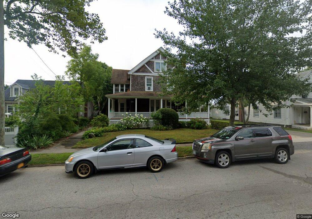
55 E 2nd St Riverhead, NY 11901
Estimated Value: $536,000 - $1,137,000
4
Beds
3
Baths
2,676
Sq Ft
$270/Sq Ft
Est. Value
About This Home
This home is located at 55 E 2nd St, Riverhead, NY 11901 and is currently estimated at $723,335, approximately $270 per square foot. 55 E 2nd St is a home located in Suffolk County with nearby schools including Pulaski Street Intermediate School, Riverhead Middle School, and Riverhead Senior High School.
Ownership History
Date
Name
Owned For
Owner Type
Purchase Details
Closed on
Mar 31, 2009
Sold by
Deutsche Bank Nat'L Trust Co
Bought by
Kuhlmann James
Current Estimated Value
Purchase Details
Closed on
Jan 30, 2004
Sold by
Green Billy
Bought by
Smith Wayne
Home Financials for this Owner
Home Financials are based on the most recent Mortgage that was taken out on this home.
Original Mortgage
$270,000
Interest Rate
5.82%
Mortgage Type
Purchase Money Mortgage
Purchase Details
Closed on
Aug 16, 2002
Sold by
Rose Jason
Bought by
Green Billy
Home Financials for this Owner
Home Financials are based on the most recent Mortgage that was taken out on this home.
Original Mortgage
$202,050
Interest Rate
6.55%
Create a Home Valuation Report for This Property
The Home Valuation Report is an in-depth analysis detailing your home's value as well as a comparison with similar homes in the area
Home Values in the Area
Average Home Value in this Area
Purchase History
| Date | Buyer | Sale Price | Title Company |
|---|---|---|---|
| Kuhlmann James | $149,900 | -- | |
| Smith Wayne | $300,000 | First American Title Ins Co | |
| Green Billy | $213,000 | -- |
Source: Public Records
Mortgage History
| Date | Status | Borrower | Loan Amount |
|---|---|---|---|
| Previous Owner | Smith Wayne | $270,000 | |
| Previous Owner | Green Billy | $202,050 |
Source: Public Records
Tax History
| Year | Tax Paid | Tax Assessment Tax Assessment Total Assessment is a certain percentage of the fair market value that is determined by local assessors to be the total taxable value of land and additions on the property. | Land | Improvement |
|---|---|---|---|---|
| 2024 | $9,511 | $39,900 | $6,500 | $33,400 |
| 2023 | $9,511 | $39,900 | $6,500 | $33,400 |
| 2022 | $7,082 | $39,900 | $6,500 | $33,400 |
| 2021 | $7,082 | $39,900 | $6,500 | $33,400 |
| 2020 | $8,574 | $39,900 | $6,500 | $33,400 |
| 2019 | $8,574 | $0 | $0 | $0 |
| 2018 | -- | $39,900 | $6,500 | $33,400 |
| 2017 | $8,412 | $39,900 | $6,500 | $33,400 |
| 2016 | $8,125 | $39,900 | $6,500 | $33,400 |
| 2015 | -- | $39,900 | $6,500 | $33,400 |
| 2014 | -- | $39,900 | $6,500 | $33,400 |
Source: Public Records
Map
Nearby Homes
- 308 East Ave
- 204 Union Ave
- 346 Maple Ave
- 131 Ostrander Ave
- 525/D17 Riverleigh
- 57 Riverleigh Ave Unit 57
- 37 Lake Ave
- 418 Lincoln St Unit 420
- 761 E Main St
- 630 Northville Turnpike
- 257 Flanders Rd
- 817 Pond View Rd
- 127 Lake Ave
- 135 Lake Ave
- 148 Woodhull Ave
- 226 Sweezy Ave
- 911 Ostrander Ave
- 660 Northville Turnpike
- 70 Strawberry Commons
- 50 Strawberry Commons
Your Personal Tour Guide
Ask me questions while you tour the home.