Estimated Value: $110,965 - $179,000
3
Beds
1
Bath
1,289
Sq Ft
$114/Sq Ft
Est. Value
About This Home
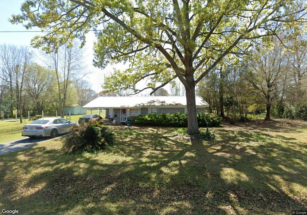
This home is located at 55 Michael Dr, Adel, GA 31620 and is currently estimated at $147,241, approximately $114 per square foot. 55 Michael Dr is a home located in Cook County with nearby schools including Cook Primary School, Cook Elementary School, and Cook County Middle School.
Ownership History
Date
Name
Owned For
Owner Type
Purchase Details
Closed on
Jul 31, 2018
Sold by
Mcginnis Margaret
Bought by
Martin Bryan E
Current Estimated Value
Purchase Details
Closed on
Mar 16, 2012
Sold by
Brown Alden R
Bought by
Toliver David F
Purchase Details
Closed on
Feb 27, 2012
Bought by
Brown Alden R
Purchase Details
Closed on
Jan 11, 2012
Purchase Details
Closed on
Jun 17, 2005
Sold by
Howell Robert C
Bought by
Hurt Danny D
Home Financials for this Owner
Home Financials are based on the most recent Mortgage that was taken out on this home.
Original Mortgage
$74,200
Interest Rate
5.66%
Mortgage Type
New Conventional
Create a Home Valuation Report for This Property
The Home Valuation Report is an in-depth analysis detailing your home's value as well as a comparison with similar homes in the area
Purchase History
| Date | Buyer | Sale Price | Title Company |
|---|---|---|---|
| Martin Bryan E | $41,800 | -- | |
| Mcginnis Margaret | $48,000 | -- | |
| Toliver David F | $28,000 | -- | |
| Brown Alden R | $8,500 | -- | |
| -- | $39,662 | -- | |
| Citifinancial Services Inc | $39,662 | -- | |
| Hurt Danny D | $74,200 | -- |
Source: Public Records
Mortgage History
| Date | Status | Borrower | Loan Amount |
|---|---|---|---|
| Previous Owner | Hurt Danny D | $74,200 |
Source: Public Records
Tax History
| Year | Tax Paid | Tax Assessment Tax Assessment Total Assessment is a certain percentage of the fair market value that is determined by local assessors to be the total taxable value of land and additions on the property. | Land | Improvement |
|---|---|---|---|---|
| 2024 | $704 | $26,146 | $3,818 | $22,328 |
| 2023 | $624 | $23,170 | $3,818 | $19,352 |
| 2022 | $613 | $22,761 | $3,409 | $19,352 |
| 2021 | $561 | $19,425 | $3,409 | $16,016 |
| 2020 | $561 | $19,425 | $3,409 | $16,016 |
| 2019 | $483 | $19,425 | $3,409 | $16,016 |
| 2018 | $562 | $19,425 | $3,409 | $16,016 |
| 2017 | $562 | $19,425 | $3,409 | $16,016 |
| 2016 | $563 | $19,425 | $3,409 | $16,016 |
| 2015 | $564 | $19,425 | $3,409 | $16,016 |
| 2014 | $565 | $19,425 | $3,409 | $16,016 |
| 2013 | -- | $26,733 | $3,409 | $23,324 |
Source: Public Records
Map
Nearby Homes
- 134 Brandy Ct
- 414 Birch St
- 703 N Elm St
- 91 Apple Ln
- 103 N College St
- 814 N Cleveland Ave
- 309 Wayne St
- 729 W 7th St
- 1607 Jimmy St
- 515 John Keigans Memorial
- 1704 Jimmy St
- 526 E Mitchell St
- 1715 Jimmy St
- 11 Antioch Rd
- 7051 Antioch Rd
- 1402 Bear Creek Rd
- 507 S Poplar St
- 211 S Gordon Ave
- 411 S Hutchinson Ave
- 701 Gloria St
- 99 Michael Dr
- 151 Debbie Dr
- 70 Michael Dr
- 101 Debbie Dr
- 16 Michael Dr
- 0 Debbie Dr
- 65 Debbie Dr
- 96 Westover Dr
- 96 Debbie Dr
- 96 Debbie Dr
- 183 Westover Dr
- 242 Westover Dr
- 123 Westover Dr
- 123 Westover Dr
- 231 Westover Dr
- 71 Westover Dr
- 191 Westover Dr
- 1530 W Mitchell St
- 1500 W Mitchell St
- 1466 W Mitchell St
Your Personal Tour Guide
Ask me questions while you tour the home.