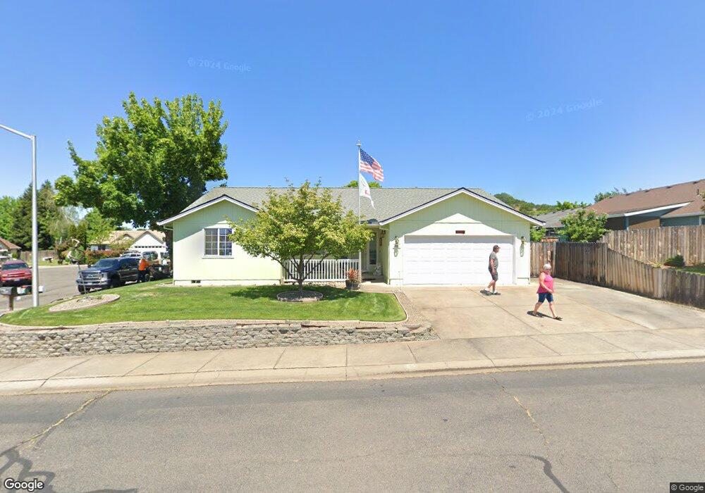
55 Osprey Dr Eagle Point, OR 97524
Estimated Value: $375,000 - $425,000
3
Beds
2
Baths
1,383
Sq Ft
$286/Sq Ft
Est. Value
About This Home
This home is located at 55 Osprey Dr, Eagle Point, OR 97524 and is currently estimated at $396,000, approximately $286 per square foot. 55 Osprey Dr is a home located in Jackson County with nearby schools including Eagle Point Middle School, White Mountain Middle School, and Eagle Point High School.
Ownership History
Date
Name
Owned For
Owner Type
Purchase Details
Closed on
Aug 15, 2022
Sold by
Breland Robert S
Bought by
Breland Living Trust
Current Estimated Value
Purchase Details
Closed on
Nov 2, 1998
Sold by
Mead Matthew D
Bought by
Breland Robert S and Breland Paula J
Home Financials for this Owner
Home Financials are based on the most recent Mortgage that was taken out on this home.
Original Mortgage
$105,520
Interest Rate
6.61%
Purchase Details
Closed on
Jun 4, 1998
Sold by
Hunts Larry D and Hunts Jane S
Bought by
Mead Matthew D
Create a Home Valuation Report for This Property
The Home Valuation Report is an in-depth analysis detailing your home's value as well as a comparison with similar homes in the area
Home Values in the Area
Average Home Value in this Area
Purchase History
| Date | Buyer | Sale Price | Title Company |
|---|---|---|---|
| Breland Living Trust | -- | None Listed On Document | |
| Breland Robert S | $131,900 | Amerititle | |
| Mead Matthew D | $32,430 | Jackson County Title |
Source: Public Records
Mortgage History
| Date | Status | Borrower | Loan Amount |
|---|---|---|---|
| Previous Owner | Breland Robert S | $105,520 |
Source: Public Records
Tax History
| Year | Tax Paid | Tax Assessment Tax Assessment Total Assessment is a certain percentage of the fair market value that is determined by local assessors to be the total taxable value of land and additions on the property. | Land | Improvement |
|---|---|---|---|---|
| 2026 | $2,061 | $183,960 | -- | -- |
| 2025 | $2,012 | $178,610 | $110,630 | $67,980 |
| 2024 | $2,012 | $173,410 | $107,400 | $66,010 |
| 2023 | $1,944 | $168,360 | $104,270 | $64,090 |
| 2022 | $1,891 | $168,360 | $104,270 | $64,090 |
| 2021 | $1,835 | $163,460 | $101,240 | $62,220 |
| 2020 | $1,949 | $158,700 | $98,290 | $60,410 |
| 2019 | $1,920 | $149,600 | $92,660 | $56,940 |
| 2018 | $1,883 | $145,250 | $89,970 | $55,280 |
| 2017 | $1,837 | $145,250 | $89,970 | $55,280 |
| 2016 | $2,188 | $136,920 | $84,810 | $52,110 |
| 2015 | $2,116 | $136,920 | $84,810 | $52,110 |
| 2014 | $1,980 | $129,070 | $79,950 | $49,120 |
Source: Public Records
Map
Nearby Homes
- 268 Robert Trent Jones Blvd
- 279 Robert Trent Jones Blvd
- 1151 Arrowhead Trail
- 1146 Pumpkin Unit 335
- 421 Stevens Rd Unit 20
- 421 Stevens Rd Unit 14
- 421 Stevens Rd Unit 52
- 1147 Pumpkin Unit 321
- 218 Cambridge Terrace
- 1152 Pumpkin Unit 334
- 1159 Pumpkin Ridge Unit 323
- 1158 Pumpkin Unit 333
- 964 Pumpkin Ridge
- 1164 Pumpkin Unit 332
- 959 Pumpkin Ridge Dr
- 1153 Pumpkin Unit 322
- 375 Robert Trent Jones Blvd
- 131 Bellerive Dr
- 1171 Pumpkin Unit 325
- The 2096 Plan at Eagle Point
Your Personal Tour Guide
Ask me questions while you tour the home.