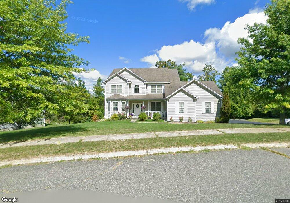
55 Westview Rd Dalton, MA 01226
Estimated Value: $665,000 - $848,000
3
Beds
4
Baths
3,309
Sq Ft
$220/Sq Ft
Est. Value
About This Home
This home is located at 55 Westview Rd, Dalton, MA 01226 and is currently estimated at $728,899, approximately $220 per square foot. 55 Westview Rd is a home located in Berkshire County with nearby schools including Wahconah Regional High School and St. Agnes Academy.
Ownership History
Date
Name
Owned For
Owner Type
Purchase Details
Closed on
Mar 28, 2008
Sold by
Long Anthony D and Long Lisa M
Bought by
Mann Sukhpal Singh and Mann Rosy
Current Estimated Value
Home Financials for this Owner
Home Financials are based on the most recent Mortgage that was taken out on this home.
Original Mortgage
$300,000
Outstanding Balance
$187,946
Interest Rate
5.76%
Mortgage Type
Purchase Money Mortgage
Estimated Equity
$540,953
Purchase Details
Closed on
Jun 12, 2003
Sold by
Pine Crest Development
Bought by
Long Anthony D and Long Lisa M
Create a Home Valuation Report for This Property
The Home Valuation Report is an in-depth analysis detailing your home's value as well as a comparison with similar homes in the area
Home Values in the Area
Average Home Value in this Area
Purchase History
| Date | Buyer | Sale Price | Title Company |
|---|---|---|---|
| Mann Sukhpal Singh | $500,000 | -- | |
| Mann Sukhpal Singh | $500,000 | -- | |
| Long Anthony D | $60,000 | -- |
Source: Public Records
Mortgage History
| Date | Status | Borrower | Loan Amount |
|---|---|---|---|
| Open | Mann Sukhpal Singh | $300,000 | |
| Closed | Mann Sukhpal Singh | $300,000 |
Source: Public Records
Tax History Compared to Growth
Tax History
| Year | Tax Paid | Tax Assessment Tax Assessment Total Assessment is a certain percentage of the fair market value that is determined by local assessors to be the total taxable value of land and additions on the property. | Land | Improvement |
|---|---|---|---|---|
| 2025 | $10,653 | $587,600 | $99,100 | $488,500 |
| 2024 | $11,002 | $604,500 | $90,700 | $513,800 |
| 2023 | $9,451 | $530,300 | $85,600 | $444,700 |
| 2022 | $9,451 | $455,700 | $85,600 | $370,100 |
| 2021 | $9,809 | $456,000 | $89,200 | $366,800 |
| 2020 | $8,798 | $433,600 | $89,200 | $344,400 |
| 2019 | $8,610 | $442,000 | $85,800 | $356,200 |
| 2018 | $8,527 | $428,300 | $85,800 | $342,500 |
| 2017 | $8,510 | $428,300 | $85,800 | $342,500 |
| 2016 | $8,408 | $428,300 | $85,800 | $342,500 |
| 2015 | $8,177 | $420,000 | $85,800 | $334,200 |
Source: Public Records
Map
Nearby Homes
- 127 Barton Hill Rd
- 48 Elaine Ave
- 1 Pondview Dr Unit C3
- 44 Eleanor Rd
- 9 Crane Ave
- 1994 East St
- 0 Crane Ave
- 13 Pleasantview Dr
- 164 Depot St
- 387 Dalton Division Rd
- 29 John St
- 687 Main St
- 750 Main St
- 774 Main St
- 111 High St
- 0 Dalton Division Rd
- 67 Oak Street Extension
- 196 Park Ave
- 39 Highlawn Dr
- 321 High St
- 55 Westview Dr
- 45 Westview Dr
- 122 Hemlock Hill
- 112 Hemlock Hill
- 188 Pinecrest Dr
- 35 Westview Rd
- 178 Pinecrest Dr
- 44 Westview Rd
- 44 Westview Dr
- 25 Hemlock Hill
- 98 Hemlock Hill
- 135 Hemlock Hill
- 34 Westview Rd
- 34 Westview Dr
- 25 Westview Rd
- 25 Westview Dr
- 121 Hemlock Hill
- 111 Hemlock Hill
- 127 Pinecrest Dr
- 101 Hemlock Hill