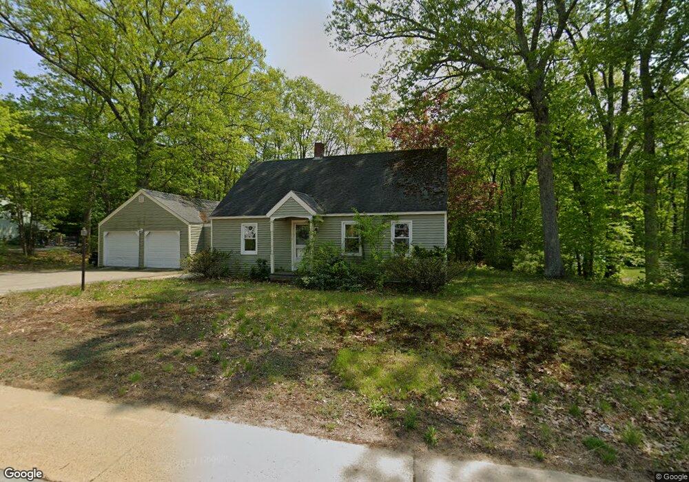
55 Whitehall Rd Rochester, NH 03867
Estimated Value: $406,000 - $456,000
3
Beds
2
Baths
1,768
Sq Ft
$244/Sq Ft
Est. Value
About This Home
This home is located at 55 Whitehall Rd, Rochester, NH 03867 and is currently estimated at $430,529, approximately $243 per square foot. 55 Whitehall Rd is a home located in Strafford County with nearby schools including Chamberlain Street School, Rochester Middle School, and Spaulding High School.
Ownership History
Date
Name
Owned For
Owner Type
Purchase Details
Closed on
Aug 12, 2003
Sold by
Miller Christopher R
Bought by
Gould Amanda
Current Estimated Value
Home Financials for this Owner
Home Financials are based on the most recent Mortgage that was taken out on this home.
Original Mortgage
$189,000
Outstanding Balance
$81,164
Interest Rate
5.28%
Estimated Equity
$349,365
Purchase Details
Closed on
Aug 1, 1997
Sold by
Lyons Kirsten F
Bought by
Miller Christopher R
Home Financials for this Owner
Home Financials are based on the most recent Mortgage that was taken out on this home.
Original Mortgage
$91,800
Interest Rate
7.55%
Create a Home Valuation Report for This Property
The Home Valuation Report is an in-depth analysis detailing your home's value as well as a comparison with similar homes in the area
Home Values in the Area
Average Home Value in this Area
Purchase History
| Date | Buyer | Sale Price | Title Company |
|---|---|---|---|
| Gould Amanda | $189,000 | -- | |
| Miller Christopher R | $90,000 | -- |
Source: Public Records
Mortgage History
| Date | Status | Borrower | Loan Amount |
|---|---|---|---|
| Open | Miller Christopher R | $189,000 | |
| Previous Owner | Miller Christopher R | $91,800 |
Source: Public Records
Tax History Compared to Growth
Tax History
| Year | Tax Paid | Tax Assessment Tax Assessment Total Assessment is a certain percentage of the fair market value that is determined by local assessors to be the total taxable value of land and additions on the property. | Land | Improvement |
|---|---|---|---|---|
| 2024 | $5,541 | $373,100 | $111,100 | $262,000 |
| 2023 | $5,647 | $219,400 | $56,600 | $162,800 |
| 2022 | $5,546 | $219,400 | $56,600 | $162,800 |
| 2021 | $5,408 | $219,400 | $56,600 | $162,800 |
| 2020 | $5,399 | $219,400 | $56,600 | $162,800 |
| 2019 | $5,463 | $219,400 | $56,600 | $162,800 |
| 2018 | $5,188 | $188,500 | $42,400 | $146,100 |
| 2017 | $4,963 | $188,500 | $42,400 | $146,100 |
| 2016 | $4,646 | $164,400 | $42,400 | $122,000 |
| 2015 | $4,628 | $164,400 | $42,400 | $122,000 |
| 2014 | $4,516 | $164,400 | $42,400 | $122,000 |
| 2013 | $4,602 | $174,600 | $56,600 | $118,000 |
| 2012 | $4,484 | $174,600 | $56,600 | $118,000 |
Source: Public Records
Map
Nearby Homes
- 3 Henrietta St
- 3 Dodge St
- 35 Franklin Heights
- 38 Western Ave
- 0 Franklin St Unit 55 4959653
- 56 Chamberlain St
- 22 Corson St
- 144 Rochester Hill Rd
- 1 Farrington St
- 15 Linden St
- 161 Lowell St
- 68 Moose Ln
- 67 Winter St
- 17 Winter St
- Lot 12 Rochester Hill Rd
- Lot 12-2 Rochester Hill Rd
- 34 Shaw Dr
- 7 Mcintire Ct
- 10 Sarah Ct
- 39 Ida Cir
- 53 Whitehall Rd
- 59 Whitehall Rd
- 58 Whitehall Rd
- 61 Whitehall Rd
- 60 Whitehall Rd
- 51B Whitehall Rd
- 62 Whitehall Rd
- 63 Whitehall Rd
- 49 Whitehall Rd
- 7 Alder Creek Ln
- 1 Alder Creek Ln
- 11 Alder Creek Ln
- 50 Whitehall Rd
- 15 Alder Creek Ln
- 6 Alder Creek Ln
- 10 Alder Creek Ln
- 19 Alder Creek Ln
- 2 Alder Creek Ln
- 14 Alder Creek Ln
- 21 Alder Creek Ln