
Estimated payment $24,105/month
Highlights
- 78.5 Acre Lot
- Corner Lot
- Lot Has A Rolling Slope
- Wooded Lot
- Outdoor Storage
- Crops
About This Lot
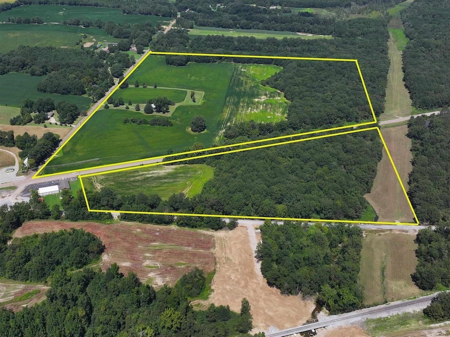
Sale comprises 3 parcels of property, lots 60, 61 and 11 as shown on the attached plat for a total of 78.5 acres, more or less. Lot 11 is zoned C-1, and lots 60 and 61 are zoned FAR. 48 Acres, more or less, are leased for farming and in crops through the end of the year, but the lease can be bought out. Property being sold for development. Five miles from Ford Blue Oval City. Railroad access nearby. GIS maps not accurate. 16 acres south of Hwy 70, 62.5 acres on the north side.
Property Details
Property Type
- Land
Est. Annual Taxes
- $832
Lot Details
- 78.5 Acre Lot
- Property fronts a state road
- Corner Lot
- Lot Has A Rolling Slope
- Wooded Lot
- Property is zoned FAR, C
Additional Features
- Crops
- Phone Available
Listing and Financial Details
- Assessor Parcel Number 133 133 06000 133 133 06100 138 138 01100
Community Details
Overview
- Unrecorded Subdivision
Recreation
- Outdoor Storage
Map
Home Values in the Area
Average Home Value in this Area
Tax History
| Year | Tax Paid | Tax Assessment Tax Assessment Total Assessment is a certain percentage of the fair market value that is determined by local assessors to be the total taxable value of land and additions on the property. | Land | Improvement |
|---|---|---|---|---|
| 2024 | $832 | $30,175 | $11,600 | $18,575 |
| 2023 | $832 | $30,175 | $11,600 | $18,575 |
| 2022 | $795 | $22,675 | $9,400 | $13,275 |
| 2021 | $794 | $22,675 | $9,400 | $13,275 |
| 2020 | $794 | $22,675 | $9,400 | $13,275 |
| 2019 | $729 | $18,775 | $8,250 | $10,525 |
| 2018 | $729 | $18,775 | $8,250 | $10,525 |
| 2017 | $729 | $18,775 | $8,250 | $10,525 |
| 2016 | $682 | $18,775 | $8,250 | $10,525 |
| 2015 | $682 | $18,775 | $8,250 | $10,525 |
| 2014 | $635 | $18,788 | $0 | $0 |
Property History
| Date | Event | Price | Change | Sq Ft Price |
|---|---|---|---|---|
| 07/08/2025 07/08/25 | For Sale | $4,390,000 | -- | -- |
Purchase History
| Date | Type | Sale Price | Title Company |
|---|---|---|---|
| Deed | -- | -- | |
| Deed | -- | -- | |
| Deed | -- | -- |
Source: Memphis Area Association of REALTORS®
MLS Number: 10200859
APN: 133-061.00
Disclaimer: Certain information contained herein is derived from information provided by parties other than Homes.com. All information provided is deemed reliable, but is not guaranteed to be accurate and should be independently verified.
![]() IDX information is provided exclusively for personal, non-commercial use, and may not be used for any purpose other than to identify prospective properties consumers may be interested in purchasing.
IDX information is provided exclusively for personal, non-commercial use, and may not be used for any purpose other than to identify prospective properties consumers may be interested in purchasing.
Information is deemed reliable but not guaranteed.
Some or all of the listings displayed may not belong to the firm whose website is being visited. Copyright© 2025 Memphis Area Association of REALTORS®.
- 39 Washington Ave
- 30 Highway 70 E
- 12112 Main St
- 11766 Main St
- 11554 Main St
- 190 U S 70
- 0 Route 59
- 0 Gainesville Ln Unit 10181112
- 132 Brookside Ave
- 101 Foxchase Dr
- 102 Foxchase Dr
- 32 Foxchase Dr
- 0 Old L & Rd N Unit 10201452
- 9930 59 Hwy S
- 0 Hwy 59 Hwy Unit 10189659
- 0 Hwy 59 Hwy Unit 10189658
- 710 Belmont Rd
- 0 Mason-Malone Rd
- 0 Bud Eubanks Rd
- 130 Belmont Rd
- 123 Hillcrest St
- 34 S Main St
- 6271 Queens College Dr
- 65 Vandy Ave
- 287 Wylie Dr
- 6111 Lubiani Valley Dr
- 17175 Tn-194
- 1981 Cottonwood Place
- 12262 Kathleen Cove
- 5118 Lawrenceburg Ln E
- 340 Driftwood Loop
- 11773 Village Center St
- 1100 Tatlock Ave Unit 42
- 5466 Scarlet Fields Dr
- 95 Fairoaks Dr
- 327 Baxter Ave
- 47 Sean Cove
- 170 Oaksedge Dr
- 75 Oakridge Cove
- 15 Oakridge Cove
