Estimated Value: $321,536 - $402,000
2
Beds
1
Bath
1,338
Sq Ft
$265/Sq Ft
Est. Value
About This Home
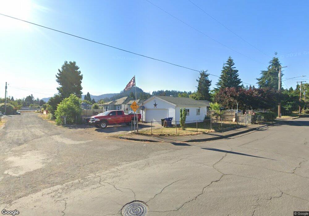
This home is located at 5505 B St, Springfield, OR 97478 and is currently estimated at $354,384, approximately $264 per square foot. 5505 B St is a home located in Lane County with nearby schools including Riverbend Elementary School, Agnes Stewart Middle School, and Thurston High School.
Ownership History
Date
Name
Owned For
Owner Type
Purchase Details
Closed on
Mar 11, 2021
Sold by
Elkins Samuel
Bought by
Elkins Sam and Elkins Tonya
Current Estimated Value
Home Financials for this Owner
Home Financials are based on the most recent Mortgage that was taken out on this home.
Original Mortgage
$183,000
Outstanding Balance
$163,299
Interest Rate
2.7%
Mortgage Type
New Conventional
Estimated Equity
$191,085
Purchase Details
Closed on
Feb 19, 2016
Sold by
Martinez Betina N and Rodriguez Fernando M
Bought by
Abreu Francisco J and Fulgencio Marco A
Home Financials for this Owner
Home Financials are based on the most recent Mortgage that was taken out on this home.
Interest Rate
3.65%
Purchase Details
Closed on
Jul 27, 1998
Sold by
Kennedy Thomas C and Kennedy S P
Bought by
Elkins Samuel
Home Financials for this Owner
Home Financials are based on the most recent Mortgage that was taken out on this home.
Original Mortgage
$81,050
Interest Rate
6.9%
Create a Home Valuation Report for This Property
The Home Valuation Report is an in-depth analysis detailing your home's value as well as a comparison with similar homes in the area
Home Values in the Area
Average Home Value in this Area
Purchase History
| Date | Buyer | Sale Price | Title Company |
|---|---|---|---|
| Elkins Sam | -- | Western Title & Escrow | |
| Abreu Francisco J | $229,000 | -- | |
| Elkins Samuel | $90,100 | Western Pioneer Title Co |
Source: Public Records
Mortgage History
| Date | Status | Borrower | Loan Amount |
|---|---|---|---|
| Open | Elkins Sam | $183,000 | |
| Closed | Abreu Francisco J | -- | |
| Previous Owner | Elkins Samuel | $81,050 |
Source: Public Records
Tax History
| Year | Tax Paid | Tax Assessment Tax Assessment Total Assessment is a certain percentage of the fair market value that is determined by local assessors to be the total taxable value of land and additions on the property. | Land | Improvement |
|---|---|---|---|---|
| 2025 | $1,982 | $108,082 | -- | -- |
| 2024 | $1,950 | $104,934 | -- | -- |
| 2023 | $1,950 | $101,878 | $0 | $0 |
| 2022 | $1,806 | $98,911 | $0 | $0 |
| 2021 | $1,774 | $96,031 | $0 | $0 |
| 2020 | $1,722 | $93,234 | $0 | $0 |
| 2019 | $1,670 | $90,519 | $0 | $0 |
| 2018 | $1,574 | $85,323 | $0 | $0 |
| 2017 | $1,514 | $85,323 | $0 | $0 |
| 2016 | $1,482 | $82,838 | $0 | $0 |
| 2015 | $1,440 | $80,425 | $0 | $0 |
| 2014 | $1,418 | $78,083 | $0 | $0 |
Source: Public Records
Map
Nearby Homes
- 5570 B St
- 5495 A Units 69 70 71 72 St
- 5510 E St
- 5736 A St
- 205 S 54th (#11) St Unit 11
- 205 S 54th St
- 733 54th St
- 775 54th St
- 802 54th Place
- 676 58th St
- 5335 Main St Unit 236
- 5335 Main St Unit 184
- 5335 Main St Unit 197
- 5335 Main St Unit 154
- 5335 Main St Unit 187
- 658 S 57th St Unit 81
- 5660 Daisy St Unit 69
- 421 S 58th St Unit 2
- 5335 Daisy St Unit 131
- 5335 Daisy St Unit TL 0130
Your Personal Tour Guide
Ask me questions while you tour the home.