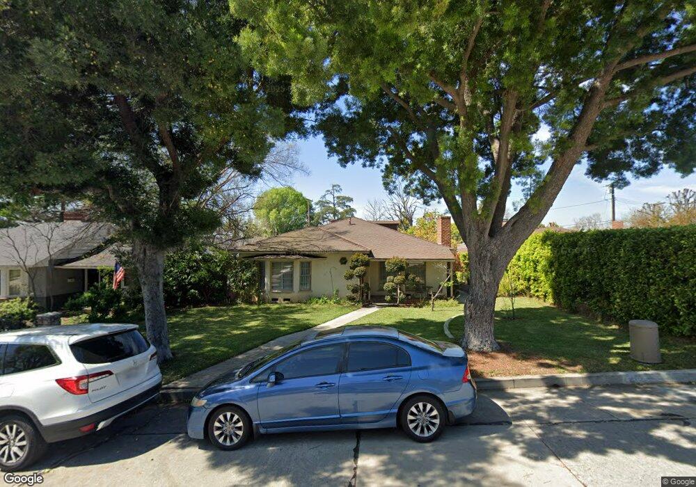
5505 Hoover Ave Whittier, CA 90601
West Whittier NeighborhoodEstimated Value: $904,000 - $1,008,000
3
Beds
2
Baths
1,897
Sq Ft
$513/Sq Ft
Est. Value
About This Home
This home is located at 5505 Hoover Ave, Whittier, CA 90601 and is currently estimated at $972,379, approximately $512 per square foot. 5505 Hoover Ave is a home located in Los Angeles County with nearby schools including Longfellow Elementary School, Walter F. Dexter Middle School, and Whittier High School.
Ownership History
Date
Name
Owned For
Owner Type
Purchase Details
Closed on
May 16, 2025
Sold by
Coronel Victor and Coronel Yolanda N
Bought by
Coronel Family Revocable Living Trust and Coronel
Current Estimated Value
Purchase Details
Closed on
Mar 17, 1999
Sold by
Beatty Harry L Co Tr
Bought by
Coronel Victor and Coronel Yolanda N
Home Financials for this Owner
Home Financials are based on the most recent Mortgage that was taken out on this home.
Original Mortgage
$209,000
Interest Rate
6.98%
Create a Home Valuation Report for This Property
The Home Valuation Report is an in-depth analysis detailing your home's value as well as a comparison with similar homes in the area
Home Values in the Area
Average Home Value in this Area
Purchase History
| Date | Buyer | Sale Price | Title Company |
|---|---|---|---|
| Coronel Family Revocable Living Trust | -- | None Listed On Document | |
| Coronel Victor | $220,000 | Old Republic Title Company |
Source: Public Records
Mortgage History
| Date | Status | Borrower | Loan Amount |
|---|---|---|---|
| Previous Owner | Coronel Victor | $209,000 |
Source: Public Records
Tax History
| Year | Tax Paid | Tax Assessment Tax Assessment Total Assessment is a certain percentage of the fair market value that is determined by local assessors to be the total taxable value of land and additions on the property. | Land | Improvement |
|---|---|---|---|---|
| 2025 | $4,586 | $344,871 | $219,154 | $125,717 |
| 2024 | $4,586 | $338,109 | $214,857 | $123,252 |
| 2023 | $4,537 | $331,481 | $210,645 | $120,836 |
| 2022 | $4,470 | $324,982 | $206,515 | $118,467 |
| 2021 | $4,329 | $318,611 | $202,466 | $116,145 |
| 2019 | $4,266 | $309,162 | $196,461 | $112,701 |
| 2018 | $4,046 | $303,101 | $192,609 | $110,492 |
| 2016 | $3,854 | $291,333 | $185,131 | $106,202 |
| 2015 | $3,819 | $286,958 | $182,351 | $104,607 |
| 2014 | $3,744 | $281,337 | $178,779 | $102,558 |
Source: Public Records
Map
Nearby Homes
- 12408 Carinthia Dr
- 12423 Beverly Dr
- 12530 Carinthia Dr
- 5628 Panorama Dr
- 5840 Citrus Ave
- 5315 Bihr Ct
- 5205 Tierra Bonita Dr
- 10602 Monaco Ct
- 5235 Andalucia Ct
- 5518 Rockne Ave
- 5522 Greenleaf Ave
- 5029 Tierra Antigua Dr Unit 107
- 5058 Tierra Antigua Dr
- 10605 Cordoba Ct
- 5422 Carley Ave
- 4807 Cinco View Dr
- 11141 Dorland St
- 11422 Ridgegate Dr
- 6260 Western Ave
- 6350 Court Ave
- 5511 Hoover Ave
- 12036 Beverly Dr
- 5517 Hoover Ave
- 5420 Acacia Ave
- 5430 Acacia Ave
- 5523 Hoover Ave
- 12120 Beverly Dr
- 5508 Acacia Ave
- 12022 Beverly Dr
- 12103 Beverly Dr
- 12109 Beverly Dr
- 12519 Beverly Dr
- 5516 Hoover Ave
- 12115 Beverly Dr
- 5529 Hoover Ave
- 12029 Beverly Dr
- 5514 Acacia Ave
- 12016 Beverly Dr
- 12121 Beverly Dr
- 12023 Beverly Dr
Your Personal Tour Guide
Ask me questions while you tour the home.