

552 W D St Springfield, OR 97477
West Springfield NeighborhoodEstimated payment $3,426/month
Highlights
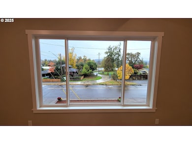
- River View
- Vaulted Ceiling
- Granite Countertops
- Deck
- 1 Fireplace
- 5-minute walk to West D Street Greenway
About This Home
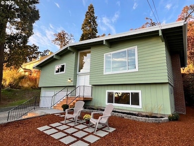
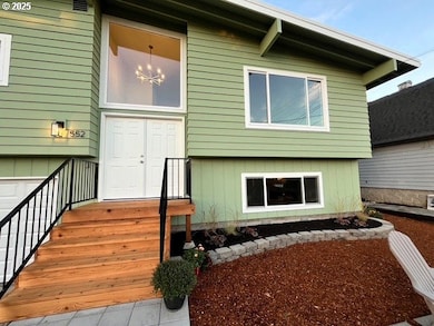
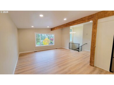
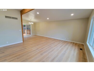
Stunning River Views, fully renovated split level! Every room in this lovely 3 bedroom has been meticulously updated and features all new LVP floor coverings, new light fixtures, new vinyl windows, and fresh paint both inside and out. The primary bedroom features an oversized walk-in closet and an on-suite bath with a walk-in shower. Two separate living areas are an ideal setup for a multi-generational household. The large back deck is perfect for entertaining, or just relaxing at the end of the day. Situated just a stones throw from the Willamette River, and the North bank river path system, this move-in ready property is surrounded by natural beauty, and primed for you to call home! Set up a showing today!
Listing Agent
Amy Dean Real Estate, Inc. Brokerage Email: amydeanrealtor@gmail.com License #200504349 Listed on: 11/05/2025
Home Details
Home Type
- Single Family
Est. Annual Taxes
- $4,888
Year Built
- Built in 1972
Lot Details
- 7,405 Sq Ft Lot
- Terraced Lot
- Landscaped with Trees
- Private Yard
Parking
- 2 Car Attached Garage
- Off-Street Parking
Property Views
- River
- City
- Woods
Home Design
- Split Level Home
- Brick Exterior Construction
- Built-Up Roof
- Wood Siding
- Concrete Perimeter Foundation
Interior Spaces
- 2,088 Sq Ft Home
- 2-Story Property
- Vaulted Ceiling
- 1 Fireplace
- Double Pane Windows
- Vinyl Clad Windows
- Family Room
- Living Room
- Dining Room
- Wall to Wall Carpet
- Laundry Room
Kitchen
- Free-Standing Range
- Microwave
- Dishwasher
- Stainless Steel Appliances
- Granite Countertops
- Disposal
Bedrooms and Bathrooms
- 3 Bedrooms
- Walk-in Shower
Outdoor Features
- Deck
- Porch
Schools
- Centennial Elementary School
- Hamlin Middle School
- Springfield High School
Utilities
- Cooling Available
- Forced Air Heating System
- Heating System Uses Gas
- Heat Pump System
- Pellet Stove burns compressed wood to generate heat
- Gas Water Heater
- High Speed Internet
Additional Features
- Accessibility Features
- Property is near bus stop
Community Details
- No Home Owners Association
Listing and Financial Details
- Assessor Parcel Number 0297364
Map
Home Values in the Area
Average Home Value in this Area
Tax History
| Year | Tax Paid | Tax Assessment Tax Assessment Total Assessment is a certain percentage of the fair market value that is determined by local assessors to be the total taxable value of land and additions on the property. | Land | Improvement |
|---|---|---|---|---|
| 2025 | $4,888 | $266,532 | -- | -- |
| 2024 | $4,808 | $258,769 | -- | -- |
| 2023 | $4,808 | $251,233 | $0 | $0 |
| 2022 | $4,453 | $243,916 | $0 | $0 |
| 2021 | $4,373 | $236,812 | $0 | $0 |
| 2020 | $4,246 | $229,915 | $0 | $0 |
| 2019 | $4,118 | $223,219 | $0 | $0 |
| 2018 | $3,882 | $210,406 | $0 | $0 |
| 2017 | $3,733 | $210,406 | $0 | $0 |
| 2016 | $3,654 | $204,278 | $0 | $0 |
| 2015 | $3,550 | $198,328 | $0 | $0 |
| 2014 | $3,497 | $192,551 | $0 | $0 |
Property History
| Date | Event | Price | List to Sale | Price per Sq Ft |
|---|---|---|---|---|
| 03/25/2026 03/25/26 | For Sale | $565,000 | 0.0% | $271 / Sq Ft |
| 03/20/2026 03/20/26 | Pending | -- | -- | -- |
| 12/05/2025 12/05/25 | Price Changed | $565,000 | -0.9% | $271 / Sq Ft |
| 11/27/2025 11/27/25 | Price Changed | $570,000 | -0.9% | $273 / Sq Ft |
| 11/05/2025 11/05/25 | For Sale | $575,000 | -- | $275 / Sq Ft |
Purchase History
| Date | Type | Sale Price | Title Company |
|---|---|---|---|
| Interfamily Deed Transfer | -- | None Available | |
| Bargain Sale Deed | $136,250 | Western Title & Escrow Co |
Mortgage History
| Date | Status | Loan Amount | Loan Type |
|---|---|---|---|
| Previous Owner | $143,000 | New Conventional |
Source: Regional Multiple Listing Service (RMLS)
MLS Number: 190976566
APN: 0297364
Disclaimer: Certain information contained herein is derived from information provided by parties other than Homes.com. All information provided is deemed reliable, but is not guaranteed to be accurate and should be independently verified.
![]() The content relating to real estate for sale on this web site comes in part from the IDX program of the RMLS™ of Portland, Oregon. Real estate listings held by brokerage firms other than Ten-X are marked with the RMLS™ logo, and detailed information about these properties includes the names of the listing brokers. Listing content is copyright © 2026 RMLS™, Portland, Oregon. Some properties which appear for sale on this web site may subsequently have sold or may no longer be available. All information provided is deemed reliable but is not guaranteed and should be independently verified.
The content relating to real estate for sale on this web site comes in part from the IDX program of the RMLS™ of Portland, Oregon. Real estate listings held by brokerage firms other than Ten-X are marked with the RMLS™ logo, and detailed information about these properties includes the names of the listing brokers. Listing content is copyright © 2026 RMLS™, Portland, Oregon. Some properties which appear for sale on this web site may subsequently have sold or may no longer be available. All information provided is deemed reliable but is not guaranteed and should be independently verified.
- 562 Kelly Blvd
- 506 W Centennial Blvd
- 275 S Garden Way
- 2327 Don St
- 475 Lindale Dr
- 2378 E 15th Ave Unit B
- 1816 10th St
- 90 Commons Dr
- 2674 Verdehill Dr
- 3230 Kinsrow Ave
- 3225 Kinsrow Ave
- 2050 E 15th Ave
- 2555 Gateway St
- 375 Marche Chase Dr
- 1965 E 15th Ave
- 1425 Villard St
- 3109 Kinsrow Ave
- 1550 Q St
- 1890 M St
- 3033-3105 NE Gateway St

Ask me questions while you tour the home.