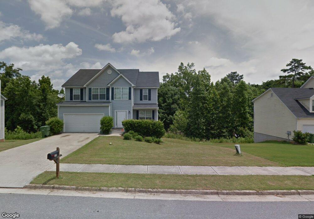
553 Michael Cir Monroe, GA 30655
Estimated Value: $310,000 - $351,000
4
Beds
3
Baths
2,093
Sq Ft
$160/Sq Ft
Est. Value
About This Home
This home is located at 553 Michael Cir, Monroe, GA 30655 and is currently estimated at $334,894, approximately $160 per square foot. 553 Michael Cir is a home located in Walton County with nearby schools including Atha Road Elementary School, Youth Middle School, and Walnut Grove High School.
Ownership History
Date
Name
Owned For
Owner Type
Purchase Details
Closed on
Apr 23, 2010
Sold by
Eastside Coml Bk
Bought by
Harvey Sherman
Current Estimated Value
Home Financials for this Owner
Home Financials are based on the most recent Mortgage that was taken out on this home.
Original Mortgage
$106,000
Outstanding Balance
$69,560
Interest Rate
4.94%
Mortgage Type
New Conventional
Estimated Equity
$265,334
Purchase Details
Closed on
Jan 20, 2006
Sold by
M & M Comtys Inc
Bought by
M & M Custom Hms Inc
Home Financials for this Owner
Home Financials are based on the most recent Mortgage that was taken out on this home.
Original Mortgage
$297,500
Interest Rate
6.14%
Create a Home Valuation Report for This Property
The Home Valuation Report is an in-depth analysis detailing your home's value as well as a comparison with similar homes in the area
Home Values in the Area
Average Home Value in this Area
Purchase History
| Date | Buyer | Sale Price | Title Company |
|---|---|---|---|
| Harvey Sherman | $106,000 | -- | |
| M & M Custom Hms Inc | $350,000 | -- |
Source: Public Records
Mortgage History
| Date | Status | Borrower | Loan Amount |
|---|---|---|---|
| Open | Harvey Sherman | $106,000 | |
| Previous Owner | M & M Custom Hms Inc | $297,500 |
Source: Public Records
Tax History
| Year | Tax Paid | Tax Assessment Tax Assessment Total Assessment is a certain percentage of the fair market value that is determined by local assessors to be the total taxable value of land and additions on the property. | Land | Improvement |
|---|---|---|---|---|
| 2025 | $3,310 | $125,440 | $22,000 | $103,440 |
| 2024 | $3,222 | $120,880 | $22,000 | $98,880 |
| 2023 | $3,314 | $120,120 | $22,000 | $98,120 |
| 2022 | $3,096 | $101,480 | $17,200 | $84,280 |
| 2021 | $2,516 | $76,320 | $13,200 | $63,120 |
| 2020 | $2,424 | $70,840 | $12,400 | $58,440 |
| 2019 | $2,350 | $59,120 | $12,000 | $47,120 |
| 2018 | $2,064 | $59,120 | $12,000 | $47,120 |
| 2017 | $2,102 | $50,160 | $8,000 | $42,160 |
| 2016 | $1,919 | $50,960 | $8,000 | $42,960 |
| 2015 | $1,760 | $44,520 | $8,000 | $36,520 |
| 2014 | $1,470 | $36,000 | $0 | $0 |
Source: Public Records
Map
Nearby Homes
- 943 Masters Dr Unit 2
- 720 Overlook Crest
- 661 Michael Cir
- 925 Tigers Way
- 675 Michael Cir
- 679 Michael Cir
- 921 Horizon Ct
- 509 Mill Farm Ln
- 810 Hampton
- 631 St Ives Walk
- 506 Breedlove Dr
- 505 Breedlove Dr
- 911 Woodchase Dr
- 823 Legends Dr
- 0 Pine View Dr Unit CL350808
- 0 Pine View Dr Unit 10706074
- 0 Pine View Dr Unit 7731449
- 327 Pine Cir
- 1004 Stone Creek Ln
- 299 Claiborne Way
- 549 Michael Cir
- 555 Michael Cir
- 557 Michael Cir
- 744 Overlook Crest
- 741 Overlook Crest
- 849 Overlook Trail
- 559 Michael Cir Unit 8
- 559 Michael Cir
- 559 Michael Cir Unit 559
- 740 Overlook Crest
- 545 Michael Cir
- 545 Michael Cir Unit 18
- 739 Overlook Crest
- 845 Overlook Trail
- 845 Overlook Trail
- 845 Overlook Trail Unit LOT 94 - BLOCK C
- 540 Michael Cir
- 605 Michael Cir
- 738 Overlook Crest
- 735 Overlook Crest Unit 1/67
Your Personal Tour Guide
Ask me questions while you tour the home.