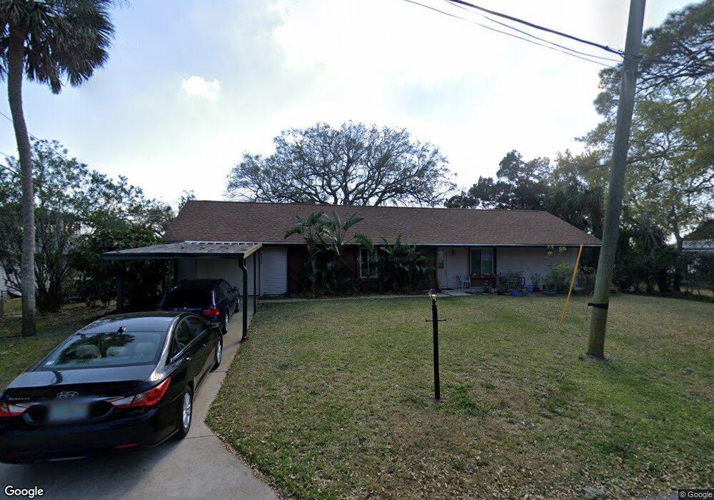
5530 W Bayshore Dr Port Orange, FL 32127
Harbor Oaks NeighborhoodEstimated Value: $285,000 - $512,000
2
Beds
2
Baths
1,361
Sq Ft
$285/Sq Ft
Est. Value
About This Home
This home is located at 5530 W Bayshore Dr, Port Orange, FL 32127 and is currently estimated at $388,557, approximately $285 per square foot. 5530 W Bayshore Dr is a home with nearby schools including Port Orange Elementary School, Silver Sands Middle School, and Spruce Creek High School.
Ownership History
Date
Name
Owned For
Owner Type
Purchase Details
Closed on
Apr 16, 2025
Sold by
Smith Richard D and Smith Elizabeth C
Bought by
Smith Richard D and Goode Stephanie
Current Estimated Value
Purchase Details
Closed on
Sep 15, 1991
Bought by
Smith Richard D and Smith Elizabeth C
Purchase Details
Closed on
May 15, 1982
Bought by
Smith Richard D and Smith Elizabeth C
Purchase Details
Closed on
May 15, 1980
Bought by
Smith Richard D and Smith Elizabeth C
Purchase Details
Closed on
Nov 15, 1970
Bought by
Smith Richard D and Smith Elizabeth C
Create a Home Valuation Report for This Property
The Home Valuation Report is an in-depth analysis detailing your home's value as well as a comparison with similar homes in the area
Home Values in the Area
Average Home Value in this Area
Purchase History
| Date | Buyer | Sale Price | Title Company |
|---|---|---|---|
| Smith Richard D | $100 | None Listed On Document | |
| Smith Richard D | $110,000 | -- | |
| Smith Richard D | $20,000 | -- | |
| Smith Richard D | $12,500 | -- | |
| Smith Richard D | $10,000 | -- |
Source: Public Records
Tax History Compared to Growth
Tax History
| Year | Tax Paid | Tax Assessment Tax Assessment Total Assessment is a certain percentage of the fair market value that is determined by local assessors to be the total taxable value of land and additions on the property. | Land | Improvement |
|---|---|---|---|---|
| 2025 | $1,807 | $146,291 | -- | -- |
| 2024 | $1,807 | $142,169 | -- | -- |
| 2023 | $1,807 | $138,029 | $0 | $0 |
| 2022 | $1,731 | $134,009 | $0 | $0 |
| 2021 | $1,758 | $130,106 | $0 | $0 |
| 2020 | $1,710 | $128,310 | $0 | $0 |
| 2019 | $1,650 | $125,425 | $0 | $0 |
| 2018 | $1,644 | $123,086 | $0 | $0 |
| 2017 | $1,643 | $120,554 | $0 | $0 |
| 2016 | $1,636 | $118,074 | $0 | $0 |
| 2015 | $1,682 | $117,253 | $0 | $0 |
| 2014 | $1,686 | $116,322 | $0 | $0 |
Source: Public Records
Map
Nearby Homes
- 5563 W Magnolia Ave
- 5650 Palm Ave
- 720 Palm Cir Dr
- 720 Palm Circle Dr
- 411 Acacia Cir
- 5585 Lancewood Cir S Unit S
- 5585 Lancewood Cir S
- 18 E Magnolia Ave
- 5476 W Bayshore Dr
- 418 Acacia Cir
- 88 E Bayshore Dr
- 24 Oak St
- 5948 Riverside Dr
- 5508 Lancewood Cir N
- 5967 Riverside Dr
- 276 Farmbrook Rd
- 5697 Christiancy Ave
- 5478 Landis Ave
- 5961 S Ridgewood Ave
- 1424 Breaks Way
- 5532 W Bayshore Dr
- 5528 W Bayshore Dr
- 5531 W Bayshore Dr
- 5529 W Bayshore Dr
- 5533 W Bayshore Dr
- 5536 W Bayshore Dr
- 5527 W Bayshore Dr
- 5535 W Bayshore Dr
- 5537 W Bayshore Dr
- 5520 W Bayshore Dr
- 5525 W Bayshore Dr
- 5516 Magnolia Ave
- 5520 Magnolia Ave
- 5539 W Bayshore Dr
- 5512 Magnolia Ave
- 5541 W Bayshore Dr
- 5518 W Bayshore Dr
- 5528 Magnolia Ave
- 5521 W Bayshore Dr
- 5508 Magnolia Ave