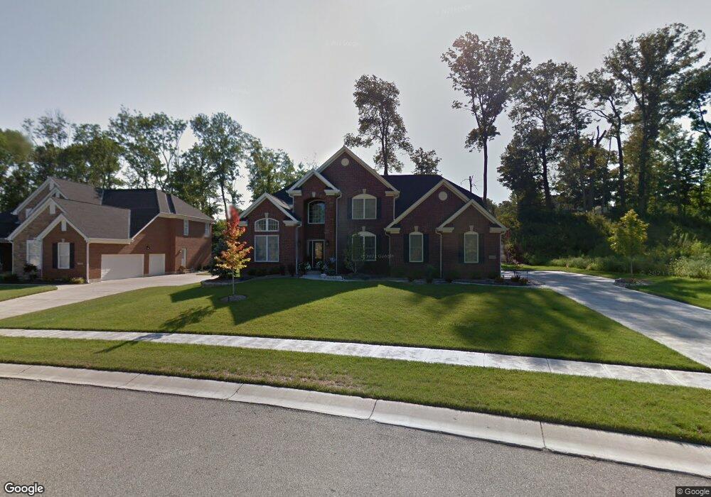
5533 Pine Brook Cir Cincinnati, OH 45247
West Monfort Heights NeighborhoodEstimated Value: $502,519 - $697,000
4
Beds
3
Baths
3,622
Sq Ft
$160/Sq Ft
Est. Value
About This Home
This home is located at 5533 Pine Brook Cir, Cincinnati, OH 45247 and is currently estimated at $577,880, approximately $159 per square foot. 5533 Pine Brook Cir is a home located in Hamilton County with nearby schools including Monfort Heights Elementary School, White Oak Middle School, and Colerain High School.
Ownership History
Date
Name
Owned For
Owner Type
Purchase Details
Closed on
Sep 21, 2009
Sold by
Masterpiece Development Inc
Bought by
Schmaltz Kenneth J and Schmaltz Lauren E
Current Estimated Value
Create a Home Valuation Report for This Property
The Home Valuation Report is an in-depth analysis detailing your home's value as well as a comparison with similar homes in the area
Home Values in the Area
Average Home Value in this Area
Purchase History
| Date | Buyer | Sale Price | Title Company |
|---|---|---|---|
| Schmaltz Kenneth J | $88,000 | Attorney |
Source: Public Records
Tax History
| Year | Tax Paid | Tax Assessment Tax Assessment Total Assessment is a certain percentage of the fair market value that is determined by local assessors to be the total taxable value of land and additions on the property. | Land | Improvement |
|---|---|---|---|---|
| 2025 | $10,146 | $185,360 | $23,100 | $162,260 |
| 2023 | $9,396 | $174,937 | $23,100 | $151,837 |
| 2022 | $8,339 | $126,655 | $27,720 | $98,935 |
| 2021 | $7,641 | $126,655 | $27,720 | $98,935 |
| 2020 | $7,717 | $126,655 | $27,720 | $98,935 |
| 2019 | $9,442 | $140,728 | $30,800 | $109,928 |
| 2018 | $8,416 | $140,728 | $30,800 | $109,928 |
| 2017 | $7,957 | $140,728 | $30,800 | $109,928 |
| 2016 | $8,437 | $147,095 | $30,492 | $116,603 |
| 2015 | $8,433 | $147,095 | $30,492 | $116,603 |
| 2014 | $8,447 | $147,095 | $30,492 | $116,603 |
| 2013 | $7,978 | $148,582 | $30,800 | $117,782 |
Source: Public Records
Map
Nearby Homes
- 5876 Sutters Mill Dr
- 5588 W Fork Rd
- 5563 Haft Rd
- 4643 Whispering Oak Trail
- 5080 Jessup Rd
- 5991 Gaines Rd
- 5804 Cedaridge Dr
- 4600 Farcrest Ct
- 5339 Race Rd
- 5547 Hubble Rd
- 6051 Shelrich Ct
- 4192 Timberpoint Dr
- 4491 W Fork Rd
- 6150 Wilmer Rd
- 6130 Wilmer Rd
- 3899 Ridgedale Dr
- 4366 Runningfawn Dr
- 4357 Hubble Rd
- 6707 Weiss Rd
- Site 1 Brierly Creek Rd
- 5698 Hickory Place Dr
- 5529 Pine Brook Cir
- 5537 Pine Brook Cir
- 5690 Hickory Place Dr
- 5525 Pine Brook Cir
- 5755 Opengate Ct
- 5741 Opengate Ct
- 5544 Pine Brook Cir
- 5769 Opengate Ct
- 5727 Opengate Ct
- 5528 Pine Brook Cir
- 5682 Hickory Place Dr Unit 4
- 5521 Pine Brook Cir
- Lot 30 Pine Brook Cir
- 5781 Opengate Ct
- 5547 Pine Brook Cir
- 5524 Pine Brook Cir
- 5715 Opengate Ct
- 27 Pinebrook Cir
- 5520 Pine Brook Cir
Your Personal Tour Guide
Ask me questions while you tour the home.