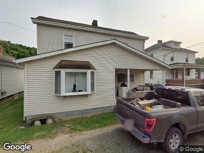
55378 W Center St Bridgeport, OH 43912
Wolfhurst NeighborhoodEstimated Value: $91,006 - $157,000
3
Beds
2
Baths
1,504
Sq Ft
$76/Sq Ft
Est. Value
About This Home
This home is located at 55378 W Center St, Bridgeport, OH 43912 and is currently estimated at $114,752, approximately $76 per square foot. 55378 W Center St is a home located in Belmont County with nearby schools including Bridgeport Elementary School, Bridgeport Middle School, and Bridgeport High School.
Ownership History
Date
Name
Owned For
Owner Type
Purchase Details
Closed on
Jun 26, 2006
Sold by
Burlenski Richard L
Bought by
Burlenski Richard Louis and Burlenski Daniel James
Current Estimated Value
Purchase Details
Closed on
Jan 1, 1986
Sold by
Burlenski Richard L
Bought by
Burlenski Richard L
Create a Home Valuation Report for This Property
The Home Valuation Report is an in-depth analysis detailing your home's value as well as a comparison with similar homes in the area
Home Values in the Area
Average Home Value in this Area
Purchase History
| Date | Buyer | Sale Price | Title Company |
|---|---|---|---|
| Burlenski Richard Louis | -- | None Available | |
| Burlenski Richard L | -- | -- |
Source: Public Records
Mortgage History
| Date | Status | Borrower | Loan Amount |
|---|---|---|---|
| Open | Burlenski Richard Louis | $5,531 | |
| Closed | Burlenski Richard L | $5,531 |
Source: Public Records
Tax History Compared to Growth
Tax History
| Year | Tax Paid | Tax Assessment Tax Assessment Total Assessment is a certain percentage of the fair market value that is determined by local assessors to be the total taxable value of land and additions on the property. | Land | Improvement |
|---|---|---|---|---|
| 2024 | $666 | $26,420 | $2,260 | $24,160 |
| 2023 | $510 | $22,350 | $2,170 | $20,180 |
| 2022 | $526 | $22,350 | $2,166 | $20,184 |
| 2021 | $523 | $22,350 | $2,166 | $20,184 |
| 2020 | $415 | $18,810 | $1,810 | $17,000 |
| 2019 | $417 | $18,810 | $1,810 | $17,000 |
| 2018 | $417 | $18,810 | $1,810 | $17,000 |
| 2017 | $407 | $17,640 | $2,650 | $14,990 |
| 2016 | $412 | $17,640 | $2,650 | $14,990 |
| 2015 | $410 | $17,640 | $2,650 | $14,990 |
| 2014 | $395 | $17,400 | $2,410 | $14,990 |
| 2013 | $369 | $17,400 | $2,410 | $14,990 |
Source: Public Records
Map
Nearby Homes
- 68290 Orchard Ave
- 68511 Liston Ave
- 68520 Scott St
- 56559 Boyd Ave
- 67070 Willow Brook Ln
- 1116 Howard St
- 810 Howard St
- 67578 Kirkwood Heights Rd
- 67551 Kirkwood Heights Rd
- 516 Bennett St
- 508 W Bennett
- 67656 Kirkwood Heights Rd
- 53350 High Ridge Rd
- 67730 Kirkwood Heights Rd
- 0 Poplar Dr Unit 4491238
- 53206 Poplar Dr
- 35 Laipple St
- 211 Scotts Ln
- 69479 Sunset Heights
- 56745 Ferryview Rd
- 55378 W Center St
- 55382 W Center St
- 55360 W Center St
- 67978 Walnut St
- 55356 W Center St
- 55413 Wabash St
- 55409 Wabash St
- 68000 Walnut St
- 55350 W Center St
- 55600 E Center St
- 67999 Walnut St
- 55340 W Center St
- 55375 Wabash St
- 55357 W Center St
- 55610 E Center St
- 55400 Wabash St
- 55410 Wabash St
- 55390 Wabash St
- 55380 Wabash St
- 55620 E Center St