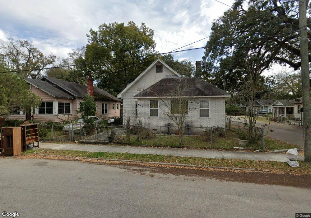
554 W 19th St Jacksonville, FL 32206
Springfield NeighborhoodEstimated Value: $106,000 - $200,000
4
Beds
1
Bath
1,613
Sq Ft
$88/Sq Ft
Est. Value
About This Home
This home is located at 554 W 19th St, Jacksonville, FL 32206 and is currently estimated at $141,545, approximately $87 per square foot. 554 W 19th St is a home located in Duval County with nearby schools including John E. Ford School, Matthew W. Gilbert Middle School, and William M. Raines High School.
Ownership History
Date
Name
Owned For
Owner Type
Purchase Details
Closed on
Mar 30, 2000
Sold by
Briggs Gwendolyn D
Bought by
Goins Annette S
Current Estimated Value
Purchase Details
Closed on
Aug 4, 1999
Sold by
Goins Annette S and Collins Buddie C
Bought by
Briggs Gwendolyn D
Purchase Details
Closed on
Dec 27, 1997
Sold by
Drivas Tony
Bought by
Hunt Catherine
Create a Home Valuation Report for This Property
The Home Valuation Report is an in-depth analysis detailing your home's value as well as a comparison with similar homes in the area
Home Values in the Area
Average Home Value in this Area
Purchase History
| Date | Buyer | Sale Price | Title Company |
|---|---|---|---|
| Goins Annette S | $14,700 | -- | |
| Briggs Gwendolyn D | $1,500 | -- | |
| Briggs Gwendolyn D | $1,500 | -- | |
| Briggs Gwendolyn D | $1,500 | -- | |
| Briggs Gwendolyn D | $1,500 | -- | |
| Briggs Gwendolyn D | $1,500 | -- | |
| Briggs Gwendolyn D | $1,500 | -- | |
| Briggs Gwendolyn D | $1,500 | -- | |
| Briggs Gwendolyn D | $1,500 | -- | |
| Briggs Gwendolyn D | $1,500 | -- | |
| Briggs Gwendolyn D | $1,500 | -- | |
| Hunt Catherine | $9,500 | -- |
Source: Public Records
Tax History Compared to Growth
Tax History
| Year | Tax Paid | Tax Assessment Tax Assessment Total Assessment is a certain percentage of the fair market value that is determined by local assessors to be the total taxable value of land and additions on the property. | Land | Improvement |
|---|---|---|---|---|
| 2025 | $289 | $42,967 | -- | -- |
| 2024 | $282 | $41,757 | -- | -- |
| 2023 | $282 | $40,541 | $0 | $0 |
| 2022 | $291 | $39,361 | $0 | $0 |
| 2021 | $289 | $38,215 | $0 | $0 |
| 2020 | $287 | $37,688 | $0 | $0 |
| 2019 | $285 | $36,841 | $0 | $0 |
| 2018 | $0 | $36,155 | $0 | $0 |
| 2017 | $0 | $35,412 | $0 | $0 |
| 2016 | $56 | $34,684 | $0 | $0 |
| 2015 | -- | $41,825 | $0 | $0 |
| 2014 | -- | $41,494 | $0 | $0 |
Source: Public Records
Map
Nearby Homes
- 554 W 18th St
- 2822 Flanders St Unit 8-19
- 533 W 18th St
- 2830 Saturn Ave
- 2829 Jupiter Ave
- 502 W 18th St
- 725 W 16th St
- 546 W 23rd St
- 0 W 12th St Unit 2080081
- 0 W 12th St Unit 2089516
- 425 W 22nd St
- 540 W 24th St
- 421 W 23rd St
- 232 W 19th St
- 206 W 16th St
- 1015 W 17th St
- 916 W 24th St
- 1058 W 17th St
- 434 W 25th St
- 0 W 18th St Unit 2053530
- 542 W 19th St
- 553 W 18th St
- 551 W 18th St
- 2830 Flanders St
- 2822 Flanders St
- 536 W 19th St
- 545 W 18th St
- 2836 Flanders St
- 2903 Flanders St
- 551 W 19th St
- 2816 Flanders St
- 543 W 19th St
- 537 W 18th St
- 610 W 20th St
- 2810 Flanders St
- 530 W 19th St
- 537 W 19th St
- 2802 Flanders St
- 710 W 18th St
- 531 W 19th St