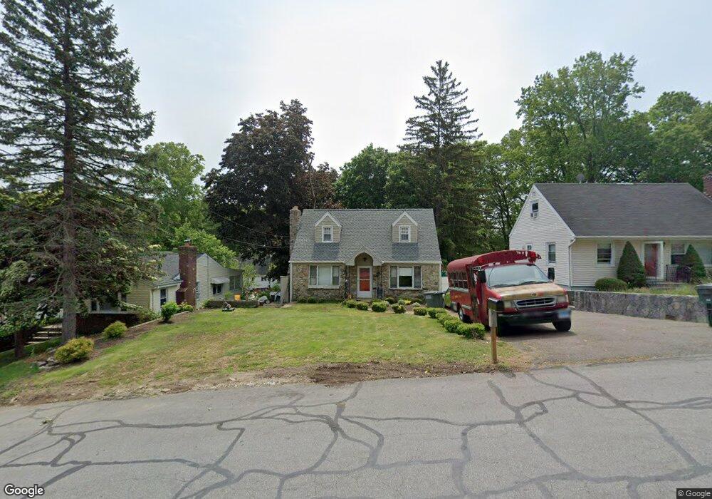
555 Lakeside Dr Bridgeport, CT 06606
North End NeighborhoodEstimated Value: $406,000 - $485,000
3
Beds
2
Baths
1,381
Sq Ft
$331/Sq Ft
Est. Value
About This Home
This home is located at 555 Lakeside Dr, Bridgeport, CT 06606 and is currently estimated at $457,210, approximately $331 per square foot. 555 Lakeside Dr is a home located in Fairfield County with nearby schools including Wilbur L. Cross Elementary School, Central High School, and St Andrew School.
Ownership History
Date
Name
Owned For
Owner Type
Purchase Details
Closed on
Feb 25, 2009
Sold by
Flacks Irvin W and Flacks Lyon A
Bought by
Horn James F
Current Estimated Value
Purchase Details
Closed on
Aug 29, 2001
Sold by
Wilson George and Wilson Sabina M
Bought by
Flacks Irvin W and Flacks Lynn A
Purchase Details
Closed on
Aug 28, 1992
Sold by
Zarrella Lawrence and Zarrella Marylou
Bought by
Wilson George
Create a Home Valuation Report for This Property
The Home Valuation Report is an in-depth analysis detailing your home's value as well as a comparison with similar homes in the area
Home Values in the Area
Average Home Value in this Area
Purchase History
| Date | Buyer | Sale Price | Title Company |
|---|---|---|---|
| Horn James F | $245,500 | -- | |
| Horn James F | $245,500 | -- | |
| Flacks Irvin W | $165,900 | -- | |
| Flacks Irvin W | $165,900 | -- | |
| Wilson George | $115,000 | -- | |
| Wilson George | $115,000 | -- |
Source: Public Records
Mortgage History
| Date | Status | Borrower | Loan Amount |
|---|---|---|---|
| Open | Wilson George | $228,190 | |
| Previous Owner | Wilson George | $120,000 |
Source: Public Records
Tax History
| Year | Tax Paid | Tax Assessment Tax Assessment Total Assessment is a certain percentage of the fair market value that is determined by local assessors to be the total taxable value of land and additions on the property. | Land | Improvement |
|---|---|---|---|---|
| 2025 | $7,162 | $164,830 | $83,850 | $80,980 |
| 2024 | $7,162 | $164,830 | $83,850 | $80,980 |
| 2023 | $7,162 | $164,830 | $83,850 | $80,980 |
| 2022 | $7,162 | $164,830 | $83,850 | $80,980 |
| 2021 | $7,162 | $164,830 | $83,850 | $80,980 |
| 2020 | $7,120 | $131,880 | $63,480 | $68,400 |
| 2019 | $7,120 | $131,880 | $63,480 | $68,400 |
| 2018 | $7,170 | $131,880 | $63,480 | $68,400 |
| 2017 | $7,170 | $131,880 | $63,480 | $68,400 |
| 2016 | $7,170 | $131,880 | $63,480 | $68,400 |
| 2015 | $6,669 | $158,040 | $72,020 | $86,020 |
| 2014 | $6,669 | $158,040 | $72,020 | $86,020 |
Source: Public Records
Map
Nearby Homes
- 563 Lakeside Dr
- 74 Village Ln
- 11 Linda Dr
- 1403 Old Town Rd Unit 1403
- 1376 Chopsey Hill Rd
- 291 Frenchtown Rd
- 364 Griffin Ave
- 45 Frenchtown Rd
- 65 Bonnie View Dr
- 1320 Chopsey Hill Rd
- 93 Oxford St Unit 95
- 114 Oxford St
- 65 Clearview Dr
- 26 Victory St
- 114 Minturn Place
- 110 Minturn Rd
- 26 Karen Ct Unit A
- 70 Pleasantview Ave
- 35 Marcel St
- 82 Yaremich Dr
- 575 Lakeside Dr
- 543 Lakeside Dr
- 585 Lakeside Dr
- 69 Woodbine Cir
- 499 Lakeside Dr
- 55 Woodbine Cir
- 599 Lakeside Dr
- 489 Lakeside Dr
- 39 Woodbine Cir
- 611 Lakeside Dr
- 516 Lakeside Dr
- 625 Lakeside Dr
- 530 Lakeside Dr
- 580 Lakeside Dr
- 590 Lakeside Dr
- 570 Lakeside Dr
- 500 Lakeside Dr
- 540 Lakeside Dr
- 610 Lakeside Dr
- 40 Woodbine Cir
Your Personal Tour Guide
Ask me questions while you tour the home.