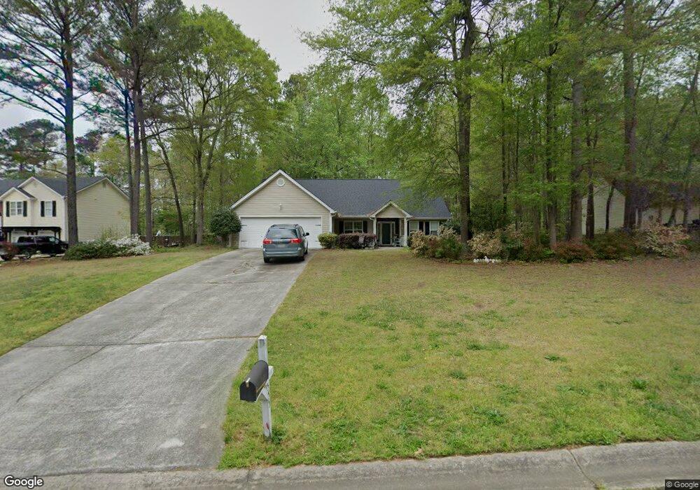
555 Saddle Ridge Dr Bethlehem, GA 30620
Estimated Value: $315,000 - $343,505
--
Bed
2
Baths
1,753
Sq Ft
$187/Sq Ft
Est. Value
About This Home
This home is located at 555 Saddle Ridge Dr, Bethlehem, GA 30620 and is currently estimated at $327,876, approximately $187 per square foot. 555 Saddle Ridge Dr is a home located in Barrow County with nearby schools including Yargo Elementary School, Haymon-Morris Middle School, and Apalachee High School.
Ownership History
Date
Name
Owned For
Owner Type
Purchase Details
Closed on
May 8, 2003
Sold by
Jones/Son Construction Inc
Bought by
Biderman Raymond E and Biderman Joan
Current Estimated Value
Purchase Details
Closed on
Jul 24, 2002
Sold by
Belmont Neighborhood
Bought by
Jones and Son Construc
Purchase Details
Closed on
Nov 23, 1999
Bought by
Belmont Neighborhood
Create a Home Valuation Report for This Property
The Home Valuation Report is an in-depth analysis detailing your home's value as well as a comparison with similar homes in the area
Home Values in the Area
Average Home Value in this Area
Purchase History
| Date | Buyer | Sale Price | Title Company |
|---|---|---|---|
| Biderman Raymond E | $127,900 | -- | |
| Jones | $30,000 | -- | |
| Belmont Neighborhood | -- | -- |
Source: Public Records
Tax History Compared to Growth
Tax History
| Year | Tax Paid | Tax Assessment Tax Assessment Total Assessment is a certain percentage of the fair market value that is determined by local assessors to be the total taxable value of land and additions on the property. | Land | Improvement |
|---|---|---|---|---|
| 2024 | $2,883 | $114,707 | $24,000 | $90,707 |
| 2023 | $3,316 | $115,107 | $24,000 | $91,107 |
| 2022 | $2,532 | $86,631 | $16,000 | $70,631 |
| 2021 | $2,284 | $73,463 | $16,000 | $57,463 |
| 2020 | $1,744 | $73,463 | $16,000 | $57,463 |
| 2019 | $1,510 | $64,684 | $16,000 | $48,684 |
| 2018 | $1,408 | $62,284 | $13,600 | $48,684 |
| 2017 | $1,384 | $47,546 | $13,600 | $33,946 |
| 2016 | $897 | $45,868 | $13,600 | $32,268 |
| 2015 | $911 | $46,230 | $13,600 | $32,630 |
| 2014 | -- | $40,245 | $7,252 | $32,993 |
| 2013 | -- | $38,163 | $7,252 | $30,911 |
Source: Public Records
Map
Nearby Homes
- 1164 Otis Dr
- 704 Newnham Walk
- 1024 Lyndhurst Ln
- 1129 Loganville Hwy
- 1111 Otis Dr
- 73 Silverleaf Trail
- 934 Beaver Hill Dr
- 64 Silverleaf Trail
- 268 Silverleaf Trail
- 280 Silverleaf Trail
- 1529 Blakewood Trail
- 738 Worth Ct
- 362 Silverleaf Trail
- Lancaster Plan at The Estates at Casteel
- Buckley Plan at The Estates at Casteel
- Cardiff Plan at The Estates at Casteel
- Pearson Plan at The Estates at Casteel
- Savoy Plan at The Estates at Casteel
- Hampstead Plan at The Estates at Casteel
- Pembroke Plan at The Estates at Casteel
- 553 Saddle Ridge Dr
- 553 Saddle Ridge Dr Unit 4
- 559 Saddle Ridge Dr
- 0 Saddle Ridge Dr Unit 8238488
- 0 Saddle Ridge Dr Unit 8873602
- 0 Saddle Ridge Dr Unit 3219068
- 0 Saddle Ridge Dr Unit 7541525
- 0 Saddle Ridge Dr Unit 8009084
- 554 Saddle Ridge Dr
- 1172 Otis Dr
- 1170 Otis Dr
- 561 Saddle Ridge Dr
- 549 Saddle Ridge Dr
- 1166 Otis Dr
- 552 Saddle Ridge Dr
- 1176 Otis Dr
- 547 Saddle Ridge Dr
- 1178 Otis Dr
- 550 Saddle Ridge Dr
- 1160 Otis Dr