Estimated Value: $493,000 - $567,000
5
Beds
4
Baths
3,181
Sq Ft
$164/Sq Ft
Est. Value
About This Home
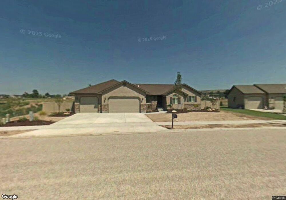
This home is located at 5563 Barton Ln, Ammon, ID 83406 and is currently estimated at $520,276, approximately $163 per square foot. 5563 Barton Ln is a home located in Bonneville County with nearby schools including Woodland Hills Elementary School, Sandcreek Middle School, and Hillcrest High School.
Ownership History
Date
Name
Owned For
Owner Type
Purchase Details
Closed on
Jun 27, 2007
Sold by
Cortland Ridge Llc
Bought by
Hamilton Matthew W and Hamilton Mary Ann
Current Estimated Value
Home Financials for this Owner
Home Financials are based on the most recent Mortgage that was taken out on this home.
Original Mortgage
$176,252
Outstanding Balance
$107,964
Interest Rate
6.21%
Mortgage Type
New Conventional
Estimated Equity
$412,312
Create a Home Valuation Report for This Property
The Home Valuation Report is an in-depth analysis detailing your home's value as well as a comparison with similar homes in the area
Purchase History
| Date | Buyer | Sale Price | Title Company |
|---|---|---|---|
| Hamilton Matthew W | -- | None Available |
Source: Public Records
Mortgage History
| Date | Status | Borrower | Loan Amount |
|---|---|---|---|
| Open | Hamilton Matthew W | $176,252 |
Source: Public Records
Tax History
| Year | Tax Paid | Tax Assessment Tax Assessment Total Assessment is a certain percentage of the fair market value that is determined by local assessors to be the total taxable value of land and additions on the property. | Land | Improvement |
|---|---|---|---|---|
| 2025 | $2,580 | $615,890 | $99,610 | $516,280 |
| 2024 | $2,491 | $593,410 | $83,070 | $510,340 |
| 2023 | $2,263 | $516,420 | $83,070 | $433,350 |
| 2022 | $2,691 | $454,563 | $72,233 | $382,330 |
| 2021 | $2,044 | $270,842 | $60,822 | $210,020 |
| 2019 | $2,168 | $246,957 | $56,087 | $190,870 |
| 2018 | $1,967 | $256,853 | $53,883 | $202,970 |
| 2017 | $1,664 | $238,203 | $53,883 | $184,320 |
| 2016 | $1,566 | $216,407 | $41,097 | $175,310 |
| 2015 | $1,552 | $199,986 | $39,366 | $160,620 |
| 2014 | $26,917 | $199,986 | $39,366 | $160,620 |
| 2013 | $1,651 | $201,085 | $39,365 | $161,720 |
Source: Public Records
Map
Nearby Homes
- 4212 E Tawzer Way
- 5559 Treyden Dr
- 5249 Barton Place
- 4378 E Highland Spring Cir
- 5258 Treyden Dr
- 3918 E Hazelwood Way
- 3876 Tawzer Way
- 4942 Remember Dr
- 4916 Remember Dr
- 5992 Cottontree Ln
- 3868 Willow Ridge Dr
- 5048 Chimney Rock Dr
- 3982 Hidden Valley Dr
- 5555 Veil Dr
- 10.614ac E 65th S
- 4736 S Thunder Dr
- TBD E 49th S
- 3709 Eugene Ave
- 4631 Mountain Bend Dr
- 3673 Eugene Ave
- 5533 Barton Ln
- 5591 Barton Ln
- 5550 Barton Ln
- 5580 Barton Ln
- 5520 Barton Ln
- 5612 Barton Ln
- 5619 Barton Ln
- 5499 Barton Cir
- 5492 Barton Ln
- 5593 Thunder Dr
- 5649 Barton Ln
- 5483 Barton Cir
- 5593 S Thunder Dr
- 5642 Barton Ln
- 5605 Thunder Dr
- 5537 S Thunder Dr
- 5565 Thunder Dr
- 5635 Thunder Dr
- 5705 Barton Ln
- 5537 Thunder Dr
Your Personal Tour Guide
Ask me questions while you tour the home.