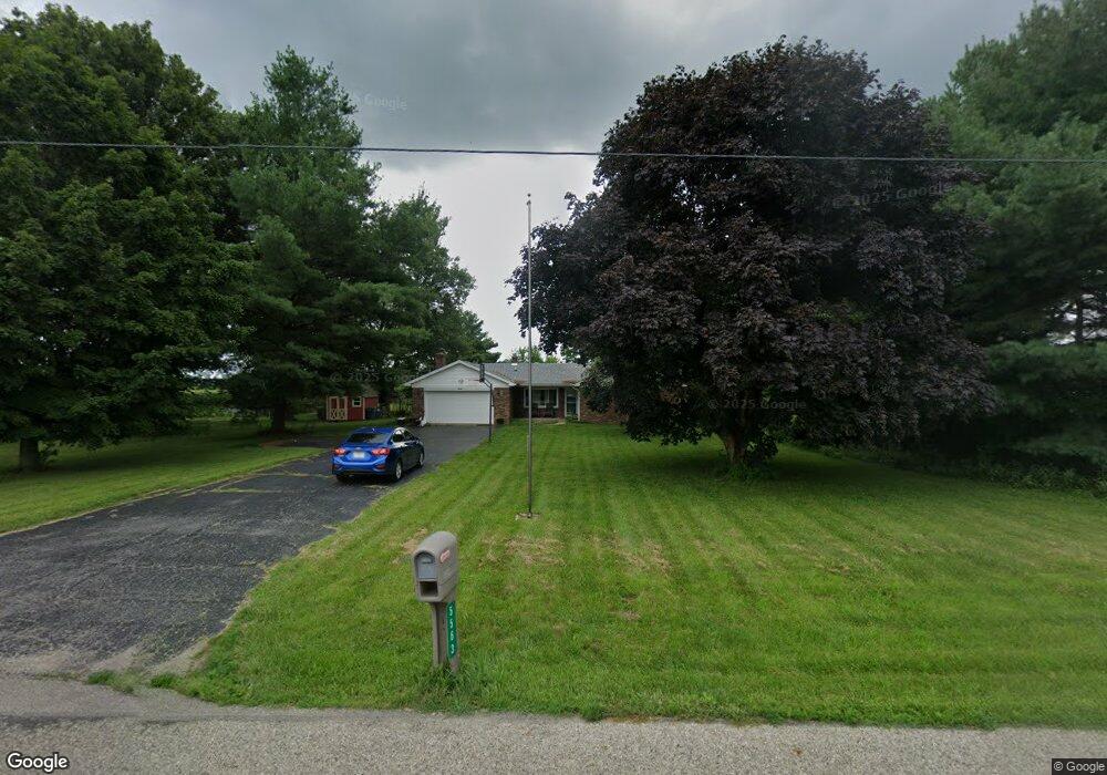
5563 E 350 N Franklin, IN 46131
Estimated Value: $314,458 - $446,000
3
Beds
2
Baths
1,395
Sq Ft
$274/Sq Ft
Est. Value
About This Home
This home is located at 5563 E 350 N, Franklin, IN 46131 and is currently estimated at $382,115, approximately $273 per square foot. 5563 E 350 N is a home located in Johnson County with nearby schools including Needham Elementary School, Franklin Community Middle School, and Custer Baker Intermediate School.
Ownership History
Date
Name
Owned For
Owner Type
Purchase Details
Closed on
Dec 1, 2020
Sold by
Beard Ryan
Bought by
Beard Ryan
Current Estimated Value
Purchase Details
Closed on
Apr 20, 2018
Sold by
Vance Michele L
Bought by
Beard Ryan
Home Financials for this Owner
Home Financials are based on the most recent Mortgage that was taken out on this home.
Original Mortgage
$160,115
Outstanding Balance
$137,696
Interest Rate
4.44%
Mortgage Type
VA
Estimated Equity
$244,419
Purchase Details
Closed on
Aug 8, 2016
Sold by
Vance Michele L
Bought by
Vance Michele L
Create a Home Valuation Report for This Property
The Home Valuation Report is an in-depth analysis detailing your home's value as well as a comparison with similar homes in the area
Home Values in the Area
Average Home Value in this Area
Purchase History
| Date | Buyer | Sale Price | Title Company |
|---|---|---|---|
| Beard Ryan | -- | Quality Title | |
| Beard Ryan | -- | -- | |
| Vance Michele L | -- | None Available | |
| Beard Ryan Keith | -- | None Available |
Source: Public Records
Mortgage History
| Date | Status | Borrower | Loan Amount |
|---|---|---|---|
| Open | Beard Ryan | $160,115 |
Source: Public Records
Tax History
| Year | Tax Paid | Tax Assessment Tax Assessment Total Assessment is a certain percentage of the fair market value that is determined by local assessors to be the total taxable value of land and additions on the property. | Land | Improvement |
|---|---|---|---|---|
| 2025 | $1,722 | $238,600 | $38,700 | $199,900 |
| 2024 | $1,722 | $191,900 | $38,900 | $153,000 |
| 2023 | $1,619 | $184,200 | $38,200 | $146,000 |
| 2022 | $1,853 | $184,200 | $38,200 | $146,000 |
| 2021 | $1,369 | $143,100 | $33,100 | $110,000 |
| 2020 | $1,081 | $123,100 | $29,000 | $94,100 |
| 2019 | $1,040 | $123,400 | $29,300 | $94,100 |
| 2018 | $1,782 | $124,300 | $29,300 | $95,000 |
| 2017 | $2,490 | $124,000 | $29,500 | $94,500 |
| 2016 | $1,030 | $115,500 | $29,600 | $85,900 |
| 2014 | $1,004 | $114,200 | $29,700 | $84,500 |
| 2013 | $1,004 | $120,000 | $29,400 | $90,600 |
Source: Public Records
Map
Nearby Homes
- 1132 Jubilee Ln
- 1157 Jubilee Ln
- 1118 Jubilee Ln
- 1110 Jubilee Ln
- 1190 Blackstone Ave
- 1166 Blackstone Ave
- 1117 Winterfield Blvd
- 1152 Blackstone Ave
- 1111 Winterfield Blvd
- 2731 Muirfield St
- 2707 Muirfield St
- 2341 Somerset Cir
- 2298 Somerset Dr
- 2478 Cedarmill Dr
- 2250 Somerset Dr
- 2148 Heather Glen Way
- 2159 Somerset Dr
- 2388 Cedarmill Dr
- 2425 Bristol Dr
- 2458 Bristol Dr
- 5585 E 350 N
- 5451 E 350 N
- 5451 E 350 N
- 5500 E 350 N
- 5307 E 350 N
- 3259 N 525 E
- 3413 N 525 E
- 3405 N 525 E
- 4200 525 E
- 4200 525 E
- 3623 N 525 E
- 5883 E 350 N
- 3713 N County Road 525 E
- 3713 N 525 E
- 3713 N 525 E
- 5915 E 350 N
- 5915 E 350 N
- 0 N 600 E Unit 21686388
- 0 N 600 E Unit 21451812
- 0 N 600 E Unit 21451816
Your Personal Tour Guide
Ask me questions while you tour the home.