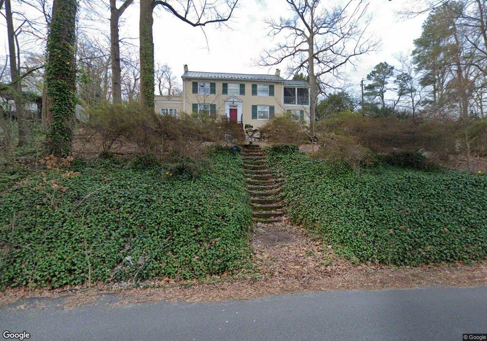
5571 Riverside Dr Richmond, VA 23225
Westover Hills NeighborhoodEstimated Value: $694,839 - $949,000
3
Beds
3
Baths
3,200
Sq Ft
$253/Sq Ft
Est. Value
About This Home
This home is located at 5571 Riverside Dr, Richmond, VA 23225 and is currently estimated at $810,210, approximately $253 per square foot. 5571 Riverside Dr is a home located in Richmond City with nearby schools including Westover Hills Elementary School, Huguenot High School, and Open High School.
Ownership History
Date
Name
Owned For
Owner Type
Purchase Details
Closed on
Nov 8, 2002
Sold by
Brown Brian A
Bought by
Atkins Susan E
Current Estimated Value
Home Financials for this Owner
Home Financials are based on the most recent Mortgage that was taken out on this home.
Original Mortgage
$178,500
Outstanding Balance
$74,876
Interest Rate
6.04%
Mortgage Type
New Conventional
Estimated Equity
$735,334
Create a Home Valuation Report for This Property
The Home Valuation Report is an in-depth analysis detailing your home's value as well as a comparison with similar homes in the area
Home Values in the Area
Average Home Value in this Area
Purchase History
| Date | Buyer | Sale Price | Title Company |
|---|---|---|---|
| Atkins Susan E | -- | -- |
Source: Public Records
Mortgage History
| Date | Status | Borrower | Loan Amount |
|---|---|---|---|
| Open | Atkins Susan E | $178,500 |
Source: Public Records
Tax History
| Year | Tax Paid | Tax Assessment Tax Assessment Total Assessment is a certain percentage of the fair market value that is determined by local assessors to be the total taxable value of land and additions on the property. | Land | Improvement |
|---|---|---|---|---|
| 2025 | $7,512 | $630,000 | $250,000 | $380,000 |
| 2024 | $7,512 | $626,000 | $250,000 | $376,000 |
| 2023 | $6,900 | $575,000 | $199,000 | $376,000 |
| 2022 | $6,240 | $520,000 | $199,000 | $321,000 |
| 2020 | $5,820 | $485,000 | $199,000 | $286,000 |
| 2019 | $5,628 | $469,000 | $199,000 | $270,000 |
| 2018 | $5,208 | $434,000 | $180,000 | $254,000 |
| 2017 | $5,040 | $420,000 | $180,000 | $240,000 |
| 2016 | $4,642 | $411,000 | $180,000 | $231,000 |
| 2015 | $4,022 | $403,000 | $180,000 | $223,000 |
| 2014 | $4,022 | $403,000 | $180,000 | $223,000 |
Source: Public Records
Map
Nearby Homes
- 5922 Osoge Rd
- 1541 Yeardley Dr
- 1214 Rothesay Cir
- 5112 Sylvan Rd
- 1408 Boroughbridge Rd
- 2841 Braidwood Rd
- 2831 Braidwood Rd
- 5013 Caledonia Rd
- 3715 Douglasdale Rd
- 6315 Forest Hill Ave
- 4902 Riverside Dr
- 1112 Sunset Ave
- 3111 Grantland Dr
- 1113 Sunset Ave
- 5210 Clarence St
- 4617 Sylvan Rd
- 5717 Jahnke Rd
- 2909 Condie St
- 5607 Jahnke Rd
- 1015 Herbert St
- 5561 Riverside Dr
- 5601 Riverside Dr
- 2439 Breckenridge Rd
- 5608 Riverside Dr
- 5612 Riverside Dr
- 5609 Riverside Dr
- 5551 Riverside Dr
- 5603 Riverside Dr
- 2431 Breckenridge Rd
- 2432 Breckenridge Rd
- 5621 Riverside Dr
- 5600 Riverside Dr
- 5606 Riverside Dr
- 5615 Riverside Dr
- 2423 Breckenridge Rd
- 5805 New Kent Rd
- 5610 Riverside Dr
- 5606 Riverside Dr
- 2414 Breckenridge Rd
- 2415 Breckenridge Rd
Your Personal Tour Guide
Ask me questions while you tour the home.