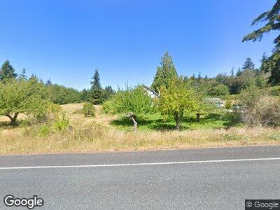
558 W Camano Hill Rd Camano Island, WA 98282
Estimated Value: $606,000 - $685,000
4
Beds
1
Bath
1,764
Sq Ft
$360/Sq Ft
Est. Value
About This Home
This home is located at 558 W Camano Hill Rd, Camano Island, WA 98282 and is currently estimated at $635,446, approximately $360 per square foot. 558 W Camano Hill Rd is a home located in Island County with nearby schools including Utsalady Elementary School, Port Susan Middle School, and Stanwood High School.
Ownership History
Date
Name
Owned For
Owner Type
Purchase Details
Closed on
May 16, 2005
Sold by
Tengelin Nancy J
Bought by
Island County
Current Estimated Value
Purchase Details
Closed on
Jan 30, 2005
Sold by
Tengelin Astrid Marie
Bought by
Tengelin Nancy J
Home Financials for this Owner
Home Financials are based on the most recent Mortgage that was taken out on this home.
Original Mortgage
$50,000
Interest Rate
5.66%
Mortgage Type
Credit Line Revolving
Create a Home Valuation Report for This Property
The Home Valuation Report is an in-depth analysis detailing your home's value as well as a comparison with similar homes in the area
Home Values in the Area
Average Home Value in this Area
Purchase History
| Date | Buyer | Sale Price | Title Company |
|---|---|---|---|
| Island County | $8,850 | -- |
Source: Public Records
Mortgage History
| Date | Status | Borrower | Loan Amount |
|---|---|---|---|
| Open | Tengelin Nancy | $277,500 | |
| Previous Owner | Tengelin Nancy J | $50,000 |
Source: Public Records
Tax History Compared to Growth
Tax History
| Year | Tax Paid | Tax Assessment Tax Assessment Total Assessment is a certain percentage of the fair market value that is determined by local assessors to be the total taxable value of land and additions on the property. | Land | Improvement |
|---|---|---|---|---|
| 2024 | $1,069 | $504,943 | $300,000 | $204,943 |
| 2023 | $1,069 | $498,268 | $290,000 | $208,268 |
| 2022 | $991 | $482,036 | $290,000 | $192,036 |
| 2021 | $926 | $336,655 | $190,000 | $146,655 |
| 2020 | $1,128 | $304,267 | $160,000 | $144,267 |
| 2019 | $1,000 | $339,945 | $230,000 | $109,945 |
| 2018 | $960 | $285,414 | $175,000 | $110,414 |
| 2017 | $911 | $261,350 | $150,000 | $111,350 |
| 2016 | $854 | $263,221 | $150,000 | $113,221 |
| 2015 | -- | $221,888 | $146,580 | $75,308 |
| 2013 | -- | $225,726 | $146,580 | $79,146 |
Source: Public Records
Map
Nearby Homes
- 0 W Cheryl Ann Dr
- 823 Admiralty Way
- 10 xx S Falcon Rd
- 1013 Loganberry Ln
- 987 Rowe Rd
- 592 Kodiak Ave
- 957 SW Camano Dr
- 884 Saratoga Way
- 822 Serene View Rd
- 815 New Morning Rd
- 993 NW Camano Dr
- 478 Eagle Crest Rd
- 408 Saylor Rd
- 1148 Westmoor Place
- 881 Lawson Rd
- 1104 Sea Mist Ln
- 664 Lactrup Spur Ln
- 955 Michael Way
- 2 Xx Woodland Beach Rd
- 2 XX Woodland Beach Rd
- 558 W Camano Hill Rd
- 579 W Camano Hill Rd
- 581 W Camano Hill Rd
- 743 Nickashawn Ln
- 1 Nikashawn Ln
- 520 Connors Rd
- 0 Chapman Rd
- 541 W Camano Hill Rd
- 515 Connors Rd
- 571 W Camano Hill Rd
- 527 W Camano Hill Rd
- 751 Nickashawn Ln
- 502 Connors Rd
- 773 Nickashawn Ln
- 0 0000 Unit NWM2071628
- 564 Forrest Way
- 534 Forrest Way
- 497 Connors Rd
- 594 Forrest Way
- 510 Forrest Way
