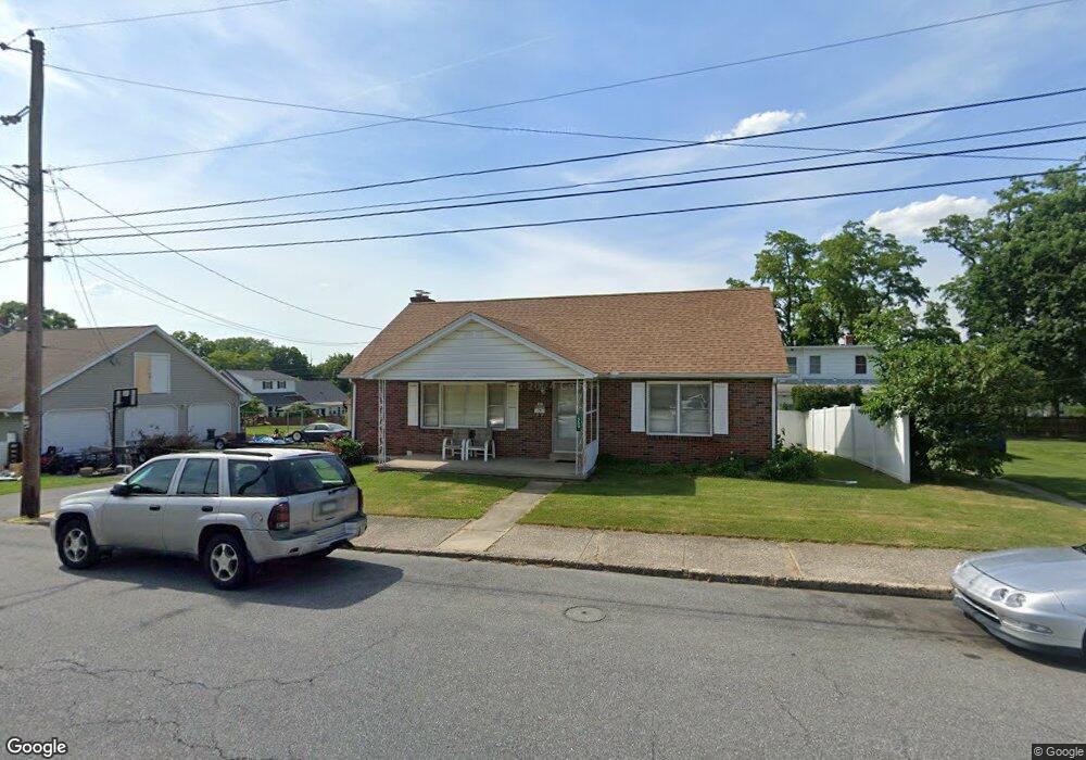
559 Wood St Emmaus, PA 18049
Estimated Value: $297,000 - $342,827
3
Beds
2
Baths
1,470
Sq Ft
$216/Sq Ft
Est. Value
About This Home
This home is located at 559 Wood St, Emmaus, PA 18049 and is currently estimated at $317,457, approximately $215 per square foot. 559 Wood St is a home located in Lehigh County with nearby schools including Lincoln Elementary School, Lower Macungie Middle School, and Emmaus High School.
Ownership History
Date
Name
Owned For
Owner Type
Purchase Details
Closed on
Dec 30, 2004
Sold by
Skrip Charles M
Bought by
Skrip Charles M
Current Estimated Value
Purchase Details
Closed on
Dec 29, 1994
Sold by
Kokolis George and Raymond Labuda
Bought by
Skrip Charles
Purchase Details
Closed on
Jun 28, 1994
Sold by
Defrain Walter C and Defrain Policare V
Bought by
Kokolis George and Raymond Labuda
Purchase Details
Closed on
Aug 22, 1988
Sold by
Defrain Walter C
Bought by
Defrain Walter C
Create a Home Valuation Report for This Property
The Home Valuation Report is an in-depth analysis detailing your home's value as well as a comparison with similar homes in the area
Home Values in the Area
Average Home Value in this Area
Purchase History
| Date | Buyer | Sale Price | Title Company |
|---|---|---|---|
| Skrip Charles M | -- | -- | |
| Skrip Charles | $125,000 | -- | |
| Kokolis George | $42,000 | -- | |
| Defrain Walter C | -- | -- |
Source: Public Records
Tax History Compared to Growth
Tax History
| Year | Tax Paid | Tax Assessment Tax Assessment Total Assessment is a certain percentage of the fair market value that is determined by local assessors to be the total taxable value of land and additions on the property. | Land | Improvement |
|---|---|---|---|---|
| 2025 | $6,393 | $181,500 | $30,200 | $151,300 |
| 2024 | $5,856 | $181,500 | $30,200 | $151,300 |
| 2023 | $5,742 | $181,500 | $30,200 | $151,300 |
| 2022 | $5,553 | $181,500 | $151,300 | $30,200 |
| 2021 | $5,414 | $181,500 | $30,200 | $151,300 |
| 2020 | $5,367 | $181,500 | $30,200 | $151,300 |
| 2019 | $58 | $181,500 | $30,200 | $151,300 |
| 2018 | $5,027 | $181,500 | $30,200 | $151,300 |
| 2017 | $4,872 | $181,500 | $30,200 | $151,300 |
| 2016 | -- | $181,500 | $30,200 | $151,300 |
| 2015 | -- | $181,500 | $30,200 | $151,300 |
| 2014 | -- | $181,500 | $30,200 | $151,300 |
Source: Public Records
Map
Nearby Homes
- 521 Wood St
- 618 Broad St
- 659 Broad St
- 569 Chestnut St Unit 571
- 657 Walnut St
- 543 Long St
- 120 N 2nd St
- 118 N 2nd St
- 339 Delong Ave Unit 343
- 97 Chestnut Hill Rd
- 4109 Eveningstar Rd
- 3430 Gentlewind Way Unit IC 109
- 101 E George St
- 4088 Eveningstar Rd
- 2571 Brunner Rd
- 3623 Daylily Dr
- 558 Beechwood St
- 340 Chestnut Hill Rd
- 3810 Allen St
- 4160 Newport Dr
- 555 Wood St
- 551 Wood St Unit 553
- 325 S 6th St
- 327 S 6th St
- 317 S 6th St
- 315 S 6th St
- 539 Wood St Unit 549
- 562 Furnace St
- 309 S 6th St Unit 311
- 560 Furnace St
- 558 Furnace St
- 576 Furnace St
- 544 Furnace St Unit 550
- 531 Wood St Unit 535
- 603 Wood St
- 538 Furnace St
- 540 Furnace St
- 401 S 6th St Unit 435
- 527 Wood St Unit 529
- 569 Furnace St