Estimated Value: $256,504 - $282,000
3
Beds
2
Baths
1,222
Sq Ft
$221/Sq Ft
Est. Value
About This Home
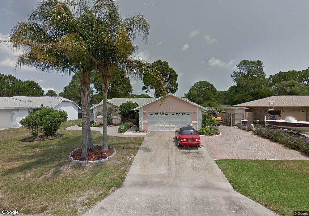
This home is located at 5590 Brandon St, Cocoa, FL 32927 and is currently estimated at $269,876, approximately $220 per square foot. 5590 Brandon St is a home located in Brevard County with nearby schools including Enterprise Elementary School, Space Coast Junior/Senior High School, and East Atlantic Prep of Brevard County.
Ownership History
Date
Name
Owned For
Owner Type
Purchase Details
Closed on
Oct 5, 2000
Sold by
Bullington Joseph P
Bought by
Bullington Joseph P and Scott Vicki L
Current Estimated Value
Purchase Details
Closed on
Feb 28, 1994
Sold by
Mountz Jay R and Mountz Ginger Lee
Bought by
Bullington Joseph P
Home Financials for this Owner
Home Financials are based on the most recent Mortgage that was taken out on this home.
Original Mortgage
$72,930
Interest Rate
7.02%
Create a Home Valuation Report for This Property
The Home Valuation Report is an in-depth analysis detailing your home's value as well as a comparison with similar homes in the area
Home Values in the Area
Average Home Value in this Area
Purchase History
| Date | Buyer | Sale Price | Title Company |
|---|---|---|---|
| Bullington Joseph P | $33,200 | -- | |
| Bullington Joseph P | $71,500 | -- |
Source: Public Records
Mortgage History
| Date | Status | Borrower | Loan Amount |
|---|---|---|---|
| Previous Owner | Bullington Joseph P | $72,930 |
Source: Public Records
Tax History
| Year | Tax Paid | Tax Assessment Tax Assessment Total Assessment is a certain percentage of the fair market value that is determined by local assessors to be the total taxable value of land and additions on the property. | Land | Improvement |
|---|---|---|---|---|
| 2025 | $3,152 | $210,250 | -- | -- |
| 2024 | $3,068 | $214,240 | -- | -- |
| 2023 | $3,068 | $211,600 | $0 | $0 |
| 2022 | $2,782 | $201,060 | $0 | $0 |
| 2021 | $2,532 | $151,300 | $42,000 | $109,300 |
| 2020 | $2,334 | $135,470 | $40,000 | $95,470 |
| 2019 | $2,268 | $130,540 | $35,000 | $95,540 |
| 2018 | $2,151 | $118,950 | $27,000 | $91,950 |
| 2017 | $838 | $59,070 | $0 | $0 |
| 2016 | $844 | $57,860 | $18,000 | $39,860 |
| 2015 | $850 | $57,460 | $15,000 | $42,460 |
| 2014 | $854 | $57,010 | $11,000 | $46,010 |
Source: Public Records
Map
Nearby Homes
- 5555 Brandon St
- 5680 Brandon St
- 7065 Hundred Acre Dr
- 6990 Bryant Rd
- 7200 Oakwood Ave
- 6815 Bryant Rd
- 7230 Venus Ave
- 6615 Dock Ave
- 6760 Cairo Rd
- 6581 Bancroft Ave
- TBD Freeport Rd
- 5740 Friendly St
- 5165 Patricia St
- 5155 Mayflower St
- 7635 Fringe Place
- 7419 Hackberry Rd
- 5715 Fairbridge St
- 6481 La Brea Ave
- 5075 Carter St
- 7429 Hackberry Rd
- 5580 Brandon St
- 5600 Brandon St
- 5595 Hemsing St
- 5585 Hemsing St
- 5605 Hemsing St
- 5570 Brandon St
- 5610 Brandon St
- 5620 Brandon St
- 5615 Brandon St
- 5595 Brandon St
- 5605 Brandon St
- 5585 Brandon St
- 5615 Hemsing St
- 5630 Brandon St
- 5560 Brandon St
- 5565 Hemsing St
- 5625 Hemsing St
- 5565 Brandon St
- 5625 Brandon St
- 5590 Hemsing St
Your Personal Tour Guide
Ask me questions while you tour the home.