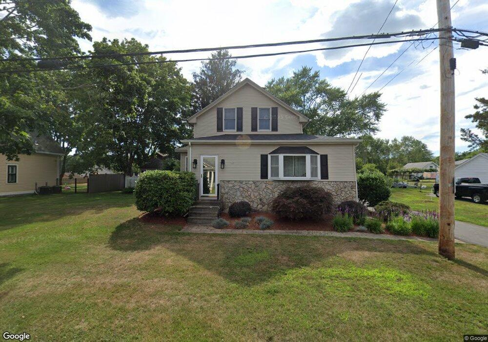
56 Blanding Rd Rehoboth, MA 02769
Estimated Value: $414,034 - $496,000
2
Beds
2
Baths
1,221
Sq Ft
$383/Sq Ft
Est. Value
About This Home
This home is located at 56 Blanding Rd, Rehoboth, MA 02769 and is currently estimated at $467,678, approximately $383 per square foot. 56 Blanding Rd is a home located in Bristol County with nearby schools including Dighton-Rehoboth Regional High School, St Margaret School, and Cedar Brook School.
Ownership History
Date
Name
Owned For
Owner Type
Purchase Details
Closed on
Aug 18, 2022
Sold by
Gagne Marc A and Gagne Linda M
Bought by
Gagne Lt
Current Estimated Value
Purchase Details
Closed on
Aug 2, 1991
Sold by
Greer William and Cole Elaine
Bought by
Gagne Marc and Gagne Linda
Home Financials for this Owner
Home Financials are based on the most recent Mortgage that was taken out on this home.
Original Mortgage
$97,800
Interest Rate
9.58%
Mortgage Type
Purchase Money Mortgage
Create a Home Valuation Report for This Property
The Home Valuation Report is an in-depth analysis detailing your home's value as well as a comparison with similar homes in the area
Home Values in the Area
Average Home Value in this Area
Purchase History
| Date | Buyer | Sale Price | Title Company |
|---|---|---|---|
| Gagne Lt | -- | None Available | |
| Gagne Marc | $51,500 | -- |
Source: Public Records
Mortgage History
| Date | Status | Borrower | Loan Amount |
|---|---|---|---|
| Previous Owner | Gagne Marc | $124,000 | |
| Previous Owner | Gagne Marc | $13,000 | |
| Previous Owner | Gagne Marc | $102,000 | |
| Previous Owner | Gagne Marc | $97,800 |
Source: Public Records
Tax History Compared to Growth
Tax History
| Year | Tax Paid | Tax Assessment Tax Assessment Total Assessment is a certain percentage of the fair market value that is determined by local assessors to be the total taxable value of land and additions on the property. | Land | Improvement |
|---|---|---|---|---|
| 2025 | $37 | $329,800 | $172,900 | $156,900 |
| 2024 | $3,668 | $322,900 | $172,900 | $150,000 |
| 2023 | $3,318 | $312,800 | $169,600 | $143,200 |
| 2022 | $3,318 | $261,900 | $161,900 | $100,000 |
| 2021 | $3,295 | $248,900 | $146,700 | $102,200 |
| 2020 | $3,142 | $239,500 | $146,700 | $92,800 |
| 2018 | $2,765 | $231,000 | $139,800 | $91,200 |
| 2017 | $2,901 | $231,000 | $139,800 | $91,200 |
| 2016 | $2,807 | $231,000 | $139,800 | $91,200 |
| 2015 | $2,656 | $215,800 | $133,200 | $82,600 |
| 2014 | $2,543 | $204,400 | $126,900 | $77,500 |
Source: Public Records
Map
Nearby Homes
- 9 Hidden Hills Dr
- 25 Lincoln St
- 824 Taunton Ave
- 67 Wheeler St
- 23 Colonial Way
- 37 Colonial Way
- 420 Chestnut St
- 16 Salisbury St
- 181 Hope St
- 0 Patterson St Unit 73348933
- 0 Winter St
- 42 Tee Jay Dr
- 6 Running Stream Rd
- 15 Hickory Ridge Rd
- 25 Pimental Dr
- 181 Sherman Ave
- 57 Redwood Ln
- 111 Summer St
- 20 School St
- 224 Arcade Ave
- 58 Blanding Rd
- 54 Blanding Rd
- 55 Blanding Rd
- 59 Blanding Rd
- 52 Blanding Rd
- 62 Blanding Rd
- 62 Blanding Rd Unit 2
- 569 Winthrop St Unit 2
- 569 Winthrop St Unit 3
- 569 Winthrop St Unit 1
- 63 Blanding Rd
- 578 Winthrop St
- 44 Blanding Rd
- 576 Winthrop St
- 68 Blanding Rd
- 570 Winthrop St
- 67 Blanding Rd
- 582 Winthrop St
- 584 Winthrop St
- 72 Blanding Rd