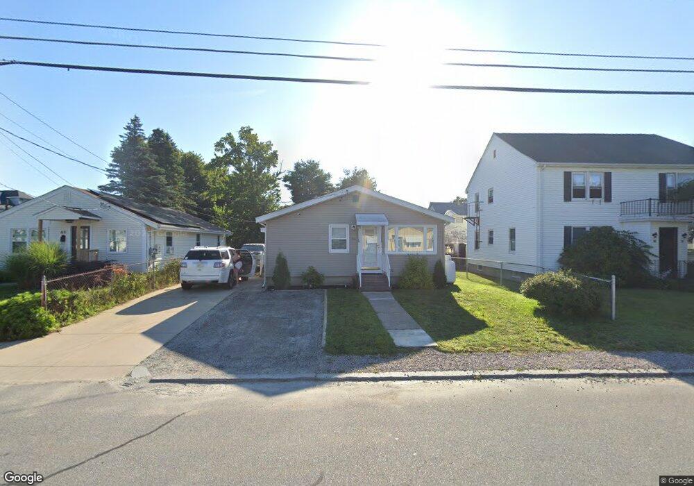
56 Knight St Woonsocket, RI 02895
Bernon District NeighborhoodEstimated Value: $334,000 - $365,472
3
Beds
1
Bath
1,092
Sq Ft
$316/Sq Ft
Est. Value
About This Home
This home is located at 56 Knight St, Woonsocket, RI 02895 and is currently estimated at $345,368, approximately $316 per square foot. 56 Knight St is a home located in Providence County with nearby schools including Woonsocket High School, Founders Academy, and Beacon Charter School.
Ownership History
Date
Name
Owned For
Owner Type
Purchase Details
Closed on
Mar 2, 2020
Sold by
Vivian Roy Lt and Roy
Bought by
Smith Wayne P and Smith Stephanie L
Current Estimated Value
Home Financials for this Owner
Home Financials are based on the most recent Mortgage that was taken out on this home.
Original Mortgage
$175,000
Outstanding Balance
$154,619
Interest Rate
3.6%
Mortgage Type
New Conventional
Estimated Equity
$190,749
Create a Home Valuation Report for This Property
The Home Valuation Report is an in-depth analysis detailing your home's value as well as a comparison with similar homes in the area
Home Values in the Area
Average Home Value in this Area
Purchase History
| Date | Buyer | Sale Price | Title Company |
|---|---|---|---|
| Smith Wayne P | $175,100 | None Available | |
| Smith Wayne P | $175,100 | None Available | |
| Smith Wayne P | $175,100 | None Available |
Source: Public Records
Mortgage History
| Date | Status | Borrower | Loan Amount |
|---|---|---|---|
| Open | Smith Wayne P | $175,000 | |
| Closed | Smith Wayne P | $175,000 |
Source: Public Records
Tax History
| Year | Tax Paid | Tax Assessment Tax Assessment Total Assessment is a certain percentage of the fair market value that is determined by local assessors to be the total taxable value of land and additions on the property. | Land | Improvement |
|---|---|---|---|---|
| 2025 | $3,969 | $353,400 | $103,900 | $249,500 |
| 2024 | $3,602 | $247,700 | $92,200 | $155,500 |
| 2023 | $3,463 | $247,700 | $92,200 | $155,500 |
| 2022 | $3,463 | $247,700 | $92,200 | $155,500 |
| 2021 | $3,553 | $149,600 | $55,900 | $93,700 |
| 2020 | $3,590 | $149,600 | $55,900 | $93,700 |
| 2018 | $3,602 | $149,600 | $55,900 | $93,700 |
| 2017 | $3,585 | $119,100 | $45,300 | $73,800 |
| 2016 | $3,792 | $119,100 | $45,300 | $73,800 |
| 2015 | $4,357 | $119,100 | $45,300 | $73,800 |
| 2014 | $2,902 | $118,500 | $49,900 | $68,600 |
Source: Public Records
Map
Nearby Homes
- 15 Knight St
- 0 Irving Lot 192 Ave Unit 1383138
- 219 Crawford St
- 122 Grand St
- 190 Crawford St
- 59 Cooper Ave
- 0 Irving Lot 206 Ave Unit 1397321
- 59 Division St
- 379 Front St
- 526 Bernon St
- 233 Grove St
- 1060 Park Ave
- 24 Paradis Ave
- 74 Maple St
- 148 Bernon St Unit 26
- 147 Warwick St
- 35 Greene St
- 99 Allen St Unit 205
- 1 Admiral St
- 180 Allen St Unit 104
- 68 Knight St
- 46 Knight St
- 0 Knight St Unit 857941
- 0 Knight St Unit 934249
- 0 Knight St Unit 953508
- 0 Knight St Unit 971875
- 0 Knight St Unit 984365
- 0 Knight St Unit 997728
- 0 Knight St Unit 1009823
- 8 Hamilton St
- 34 Knight St
- 69 Knight St
- 24 Hamilton St
- 22 Hamilton St
- 59 Knight St
- 81 Knight St
- 34 Hamilton St
- 24 Knight St
- 93 Knight St
- 41 Jackson St
Your Personal Tour Guide
Ask me questions while you tour the home.