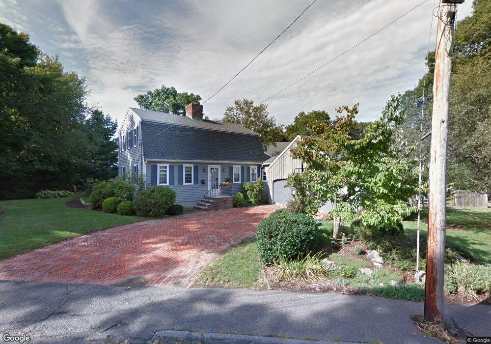
56 Pine Hill Rd Swampscott, MA 01907
Estimated Value: $851,000 - $902,000
3
Beds
2
Baths
1,884
Sq Ft
$463/Sq Ft
Est. Value
About This Home
This home is located at 56 Pine Hill Rd, Swampscott, MA 01907 and is currently estimated at $873,086, approximately $463 per square foot. 56 Pine Hill Rd is a home located in Essex County with nearby schools including Swampscott Middle School and Swampscott High School.
Ownership History
Date
Name
Owned For
Owner Type
Purchase Details
Closed on
Jan 10, 2020
Sold by
Swike Jennifer A
Bought by
Barss Ft and Barss
Current Estimated Value
Purchase Details
Closed on
Aug 10, 1979
Bought by
Barss William C and Barss Jeannette
Create a Home Valuation Report for This Property
The Home Valuation Report is an in-depth analysis detailing your home's value as well as a comparison with similar homes in the area
Home Values in the Area
Average Home Value in this Area
Purchase History
| Date | Buyer | Sale Price | Title Company |
|---|---|---|---|
| Barss Ft | -- | None Available | |
| Barss Jeannette | -- | None Available | |
| Barss Ft | -- | None Available | |
| Barss Ft | -- | None Available | |
| Barss Jeannette | -- | None Available | |
| Barss Jeannette | -- | None Available | |
| Barss William C | -- | -- |
Source: Public Records
Mortgage History
| Date | Status | Borrower | Loan Amount |
|---|---|---|---|
| Previous Owner | Barss William C | $50,000 | |
| Previous Owner | Barss William C | $60,000 | |
| Previous Owner | Barss William C | $50,000 |
Source: Public Records
Tax History Compared to Growth
Tax History
| Year | Tax Paid | Tax Assessment Tax Assessment Total Assessment is a certain percentage of the fair market value that is determined by local assessors to be the total taxable value of land and additions on the property. | Land | Improvement |
|---|---|---|---|---|
| 2025 | $9,095 | $792,900 | $457,700 | $335,200 |
| 2024 | $9,090 | $791,100 | $457,700 | $333,400 |
| 2023 | $8,598 | $732,400 | $413,000 | $319,400 |
| 2022 | $8,420 | $656,300 | $357,200 | $299,100 |
| 2021 | $8,199 | $594,100 | $323,700 | $270,400 |
| 2020 | $7,948 | $555,800 | $290,200 | $265,600 |
| 2019 | $8,109 | $533,500 | $267,900 | $265,600 |
| 2018 | $8,091 | $505,700 | $251,200 | $254,500 |
| 2017 | $8,325 | $477,100 | $234,400 | $242,700 |
| 2016 | $8,268 | $477,100 | $234,400 | $242,700 |
| 2015 | $8,182 | $477,100 | $234,400 | $242,700 |
| 2014 | $8,578 | $458,700 | $223,300 | $235,400 |
Source: Public Records
Map
Nearby Homes
- 71 Walnut Rd
- 309 Paradise Rd
- 71 Greenwood Ave Unit 207
- 306 Paradise Rd
- 75 Bay View Dr
- 13 Cedar Hill Terrace Unit 2
- 8 Ocean View Rd
- 21 Bay View Dr
- 140 Elmwood Rd
- 51 Barnstable St
- 98 Paradise Rd
- 10-12 Fairview Ave
- 76 Stetson Ave
- 2 Gracie Ln Unit 4
- 24 Orchard Cir
- 445 Essex St Unit 304
- 106 Norfolk Ave
- 8 Ryan Place
- 80 Norfolk Ave Unit 1
- 30 Paradise Rd
- 11 Lexington Cir
- 295 Forest Ave
- 3 Lexington Cir
- 3 Lexington Cir
- 15 Lexington Cir
- 60 Pine Hill Rd
- 65 Pine Hill Rd
- 289 Forest Ave
- 21 Lexington Cir
- 10 Lexington Cir
- 14 Lexington Cir
- 296 Forest Ave
- 315 Forest Ave
- 304 Forest Ave
- 25 Lexington Cir
- 6 Burke Dr
- 22 Lexington Cir
- 64 Pine Hill Rd
- 44 Mountain Ave
- 24 Huron St