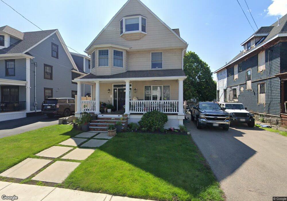
56 Sargent St Winthrop, MA 02152
Court Park NeighborhoodEstimated Value: $967,000 - $1,089,000
3
Beds
3
Baths
2,737
Sq Ft
$375/Sq Ft
Est. Value
About This Home
This home is located at 56 Sargent St, Winthrop, MA 02152 and is currently estimated at $1,027,642, approximately $375 per square foot. 56 Sargent St is a home located in Suffolk County with nearby schools including William P. Gorman/Fort Banks Elementary School, Arthur T. Cummings Elementary School, and Winthrop Middle School.
Ownership History
Date
Name
Owned For
Owner Type
Purchase Details
Closed on
Feb 3, 2003
Sold by
Miner Ft
Bought by
Babine Stephen and Babine Mariana
Current Estimated Value
Home Financials for this Owner
Home Financials are based on the most recent Mortgage that was taken out on this home.
Original Mortgage
$237,500
Interest Rate
6.09%
Mortgage Type
Purchase Money Mortgage
Create a Home Valuation Report for This Property
The Home Valuation Report is an in-depth analysis detailing your home's value as well as a comparison with similar homes in the area
Home Values in the Area
Average Home Value in this Area
Purchase History
| Date | Buyer | Sale Price | Title Company |
|---|---|---|---|
| Babine Stephen | $250,000 | -- |
Source: Public Records
Mortgage History
| Date | Status | Borrower | Loan Amount |
|---|---|---|---|
| Open | Babine Stephen | $245,000 | |
| Closed | Babine Stephen | $237,500 | |
| Previous Owner | Babine Stephen | $100,000 |
Source: Public Records
Tax History
| Year | Tax Paid | Tax Assessment Tax Assessment Total Assessment is a certain percentage of the fair market value that is determined by local assessors to be the total taxable value of land and additions on the property. | Land | Improvement |
|---|---|---|---|---|
| 2025 | $10,258 | $994,000 | $443,800 | $550,200 |
| 2024 | $10,759 | $1,032,500 | $426,500 | $606,000 |
| 2023 | $9,636 | $900,600 | $390,400 | $510,200 |
| 2022 | $9,260 | $787,400 | $348,400 | $439,000 |
| 2021 | $9,362 | $738,300 | $311,100 | $427,200 |
| 2020 | $9,317 | $738,300 | $311,100 | $427,200 |
| 2019 | $9,142 | $693,600 | $286,700 | $406,900 |
| 2018 | $8,958 | $632,600 | $246,100 | $386,500 |
| 2017 | $8,535 | $592,300 | $234,800 | $357,500 |
| 2016 | $8,498 | $552,900 | $204,100 | $348,800 |
| 2015 | $7,719 | $538,300 | $198,200 | $340,100 |
| 2014 | $7,223 | $463,600 | $152,500 | $311,100 |
Source: Public Records
Map
Nearby Homes
- 36 Sargent St
- 47 Bellevue Ave
- 66 Lowell Rd
- 191 Cottage Park Rd
- 170 Cottage Park Rd
- 35 Somerset Ave Unit 6
- 10 Somerset Ave Unit 403
- 10 Somerset Ave Unit 404
- 10 Somerset Ave Unit 207
- 10 Somerset Ave Unit 304
- 10 Somerset Ave Unit 408
- 10 Somerset Ave Unit 201
- 10 Somerset Ave Unit 405
- 10 Somerset Ave Unit 308
- 10 Somerset Ave Unit 211
- 10 Somerset Ave Unit 206
- 66 Plummer Ave Unit 3
- 63-69 Putnam St
- 550 Pleasant St Unit 506
- 56 Main St
- 62 Sargent St
- 52 Sargent St
- 66 Sargent St
- 177 Somerset Ave
- 8 Somerset Terrace
- 61 Sargent St
- 48 Sargent St
- 6 Somerset Terrace
- 55 Sargent St
- 72 Sargent St Unit 74
- 51 Sargent St
- 185 Somerset Ave Unit 1
- 185 Somerset Ave
- 65 Sargent St
- 42 Sargent St
- 76 Sargent St Unit 78
- 183 Somerset Ave
- 45 Sargent St
- 187 Somerset Ave
- 191 Somerset Ave
Your Personal Tour Guide
Ask me questions while you tour the home.