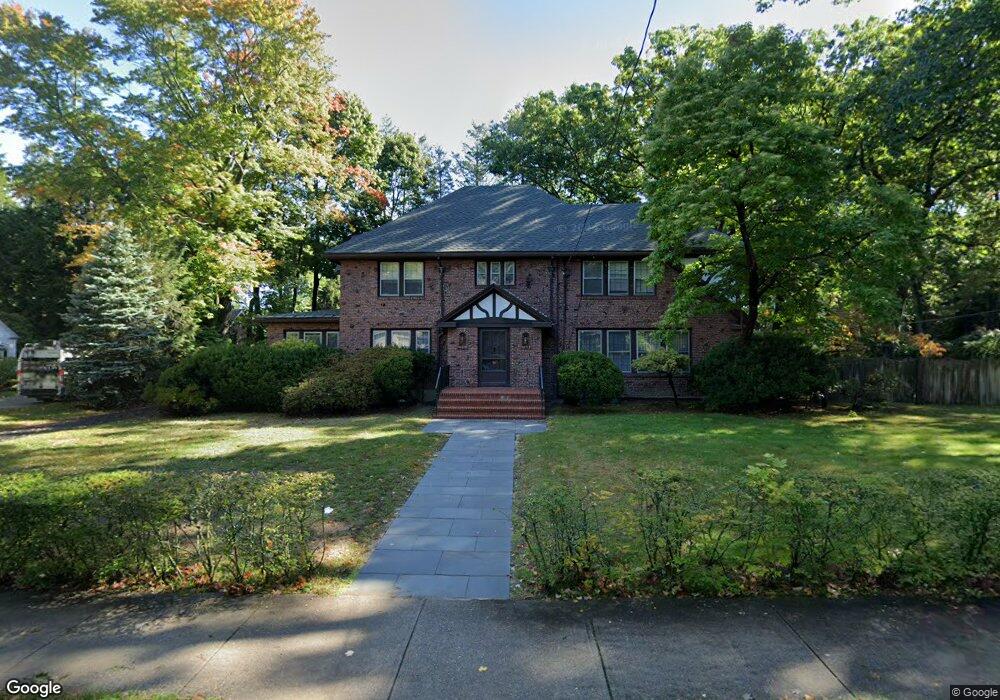
56 Somerset Rd West Newton, MA 02465
West Newton NeighborhoodEstimated Value: $2,688,108 - $3,439,000
3
Beds
3
Baths
3,596
Sq Ft
$822/Sq Ft
Est. Value
About This Home
This home is located at 56 Somerset Rd, West Newton, MA 02465 and is currently estimated at $2,957,527, approximately $822 per square foot. 56 Somerset Rd is a home located in Middlesex County with nearby schools including Peirce Elementary School, F.A. Day Middle School, and Newton North High School.
Ownership History
Date
Name
Owned For
Owner Type
Purchase Details
Closed on
Jul 2, 2008
Sold by
Rutrick Daniel and Rutrick Elena S
Bought by
Rutrick Tr Daniel and Rutrick Elena S
Current Estimated Value
Create a Home Valuation Report for This Property
The Home Valuation Report is an in-depth analysis detailing your home's value as well as a comparison with similar homes in the area
Home Values in the Area
Average Home Value in this Area
Purchase History
| Date | Buyer | Sale Price | Title Company |
|---|---|---|---|
| Rutrick Tr Daniel | -- | -- |
Source: Public Records
Tax History Compared to Growth
Tax History
| Year | Tax Paid | Tax Assessment Tax Assessment Total Assessment is a certain percentage of the fair market value that is determined by local assessors to be the total taxable value of land and additions on the property. | Land | Improvement |
|---|---|---|---|---|
| 2025 | $25,574 | $2,609,600 | $1,321,600 | $1,288,000 |
| 2024 | $24,728 | $2,533,600 | $1,283,100 | $1,250,500 |
| 2023 | $23,819 | $2,339,800 | $1,002,500 | $1,337,300 |
| 2022 | $22,792 | $2,166,500 | $928,200 | $1,238,300 |
| 2021 | $21,992 | $2,043,900 | $875,700 | $1,168,200 |
| 2020 | $21,338 | $2,043,900 | $875,700 | $1,168,200 |
| 2019 | $20,737 | $1,984,400 | $850,200 | $1,134,200 |
| 2018 | $20,163 | $1,863,500 | $767,900 | $1,095,600 |
| 2017 | $19,549 | $1,758,000 | $724,400 | $1,033,600 |
| 2016 | $18,697 | $1,643,000 | $677,000 | $966,000 |
| 2015 | $17,827 | $1,535,500 | $632,700 | $902,800 |
Source: Public Records
Map
Nearby Homes
- 70 Bigelow Rd
- 4 Hosmer Cir
- 140 Mount Vernon St
- 39 Valentine Park
- 33 Birch Hill Rd
- 318 Austin St Unit A
- 123 Mount Vernon St Unit 2
- 20 Birch Hill Rd
- 308 Prince St
- 222 Prince St
- 46 Ellis Rd
- 279 Chestnut St
- 12 Wiswall St
- 4 Wiswall St
- 79 Chestnut St Unit 2
- 1230 Commonwealth Ave
- 27 Cross St Unit 27
- 154 Beaumont Ave
- 18 Sewall St
- 61 Lakeview Ave
- 46 Somerset Rd
- 350 Highland St
- 326 Highland St
- 325 Highland Ave
- 8 Sylvan Ave
- 343 Highland St
- 133 Forest Ave
- 161 Forest Ave
- 41 Somerset Rd
- 316 Highland St
- 14 Sylvan Ave
- 34 Somerset Rd
- 146 Forest Ave
- 121 Forest Ave
- 138 Forest Ave
- 33 Somerset Rd
- 5 Sylvan Ave
- 310 Highland St
- 38 Balcarres Rd
- 363 Highland St