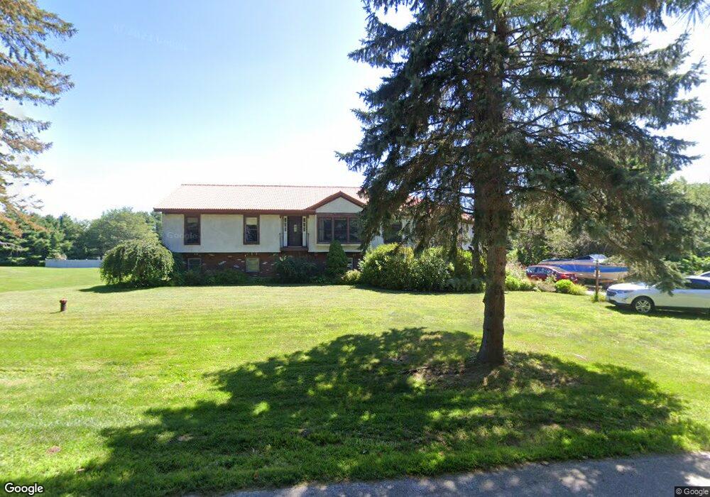
56 Vincent Dr Gilford, NH 03249
Estimated Value: $687,000 - $780,000
4
Beds
4
Baths
3,663
Sq Ft
$200/Sq Ft
Est. Value
About This Home
This home is located at 56 Vincent Dr, Gilford, NH 03249 and is currently estimated at $733,662, approximately $200 per square foot. 56 Vincent Dr is a home located in Belknap County with nearby schools including Gilford Elementary School, Gilford Middle School, and Gilford High School.
Ownership History
Date
Name
Owned For
Owner Type
Purchase Details
Closed on
Apr 13, 2010
Sold by
Fnma
Bought by
Savery Dorothy J and Williams David H
Current Estimated Value
Home Financials for this Owner
Home Financials are based on the most recent Mortgage that was taken out on this home.
Original Mortgage
$168,000
Outstanding Balance
$112,557
Interest Rate
5.12%
Mortgage Type
Purchase Money Mortgage
Estimated Equity
$621,105
Purchase Details
Closed on
Aug 25, 2009
Sold by
Peverly Richard A and Fnma
Bought by
Federal National Mortgage Association
Purchase Details
Closed on
Sep 25, 2000
Sold by
Ramos Marcos V
Bought by
Peverly Richard A and Peverly M K
Home Financials for this Owner
Home Financials are based on the most recent Mortgage that was taken out on this home.
Original Mortgage
$215,100
Interest Rate
8%
Mortgage Type
Purchase Money Mortgage
Create a Home Valuation Report for This Property
The Home Valuation Report is an in-depth analysis detailing your home's value as well as a comparison with similar homes in the area
Home Values in the Area
Average Home Value in this Area
Purchase History
| Date | Buyer | Sale Price | Title Company |
|---|---|---|---|
| Savery Dorothy J | $210,000 | -- | |
| Federal National Mortgage Association | $322,700 | -- | |
| Peverly Richard A | $239,000 | -- |
Source: Public Records
Mortgage History
| Date | Status | Borrower | Loan Amount |
|---|---|---|---|
| Open | Peverly Richard A | $168,000 | |
| Previous Owner | Peverly Richard A | $215,100 |
Source: Public Records
Tax History Compared to Growth
Tax History
| Year | Tax Paid | Tax Assessment Tax Assessment Total Assessment is a certain percentage of the fair market value that is determined by local assessors to be the total taxable value of land and additions on the property. | Land | Improvement |
|---|---|---|---|---|
| 2024 | $6,889 | $612,340 | $123,140 | $489,200 |
| 2023 | $6,307 | $612,340 | $123,140 | $489,200 |
| 2022 | $5,766 | $470,660 | $77,060 | $393,600 |
| 2021 | $5,780 | $470,660 | $77,060 | $393,600 |
| 2020 | $5,835 | $388,250 | $65,850 | $322,400 |
| 2019 | $5,894 | $371,620 | $65,320 | $306,300 |
| 2018 | $5,558 | $326,180 | $60,280 | $265,900 |
| 2017 | $5,559 | $322,080 | $60,280 | $261,800 |
| 2016 | $5,944 | $331,140 | $75,640 | $255,500 |
| 2015 | $5,843 | $325,140 | $75,640 | $249,500 |
| 2011 | $5,328 | $287,210 | $71,110 | $216,100 |
Source: Public Records
Map
Nearby Homes
- 7 Countryside Dr
- 233 Stark St
- 122 Valley St
- 162 Morrill St
- 96 Clinton St
- 6 Colonial Dr
- 75 Stark St Unit 3
- 88 Stark St
- 102 Woodland Ave
- 32 David Lewis Rd
- 74 Morrill St
- 26 Saint Catherine St
- 0 Sanborn St Unit 8 5059863
- 468 Union Ave
- 239 Gilford Ave
- 50 Belvidere St
- 29 Strafford St
- Lot 1 Winter St
- 98 Washington St
- Lot 32 Lady of the Lakes Estates
- 42 Vincent Dr
- 55 Vincent Dr
- 41 Vincent Dr
- 71 Countryside Dr
- 29 Countryside Dr
- 58 Countryside Dr
- 97 Countryside Dr
- 42 Countryside Dr
- 52 Countryside Dr
- 66 Countryside Dr
- 103 Countryside Dr
- 36 Countryside Dr
- 23 Countryside Dr
- 72 Countryside Dr
- 24 Countryside Dr
- 26 Vincent Dr
- 76 Countryside Dr
- 43 October Ln
- 25 Vincent Dr