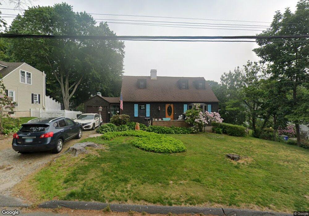
56 Yarrow Rd Fairfield, CT 06824
University NeighborhoodEstimated Value: $782,000 - $923,000
2
Beds
3
Baths
1,404
Sq Ft
$602/Sq Ft
Est. Value
About This Home
This home is located at 56 Yarrow Rd, Fairfield, CT 06824 and is currently estimated at $845,185, approximately $601 per square foot. 56 Yarrow Rd is a home located in Fairfield County with nearby schools including Osborn Hill Elementary School, Fairfield Woods Middle School, and Fairfield Ludlowe High School.
Ownership History
Date
Name
Owned For
Owner Type
Purchase Details
Closed on
Apr 24, 2018
Sold by
Benton Glenn R
Bought by
Lindsay David M and Ford Victoria D
Current Estimated Value
Purchase Details
Closed on
Dec 20, 2016
Sold by
Benton Glenn R
Bought by
Benton Glenn R and Lindsay David M
Home Financials for this Owner
Home Financials are based on the most recent Mortgage that was taken out on this home.
Original Mortgage
$299,700
Interest Rate
3.54%
Mortgage Type
New Conventional
Create a Home Valuation Report for This Property
The Home Valuation Report is an in-depth analysis detailing your home's value as well as a comparison with similar homes in the area
Home Values in the Area
Average Home Value in this Area
Purchase History
| Date | Buyer | Sale Price | Title Company |
|---|---|---|---|
| Lindsay David M | -- | -- | |
| Lindsay David M | -- | -- | |
| Benton Glenn R | -- | -- | |
| Benton Glenn R | -- | -- |
Source: Public Records
Mortgage History
| Date | Status | Borrower | Loan Amount |
|---|---|---|---|
| Previous Owner | Benton Glenn R | $299,700 | |
| Previous Owner | Benton Glenn R | $350,245 |
Source: Public Records
Tax History Compared to Growth
Tax History
| Year | Tax Paid | Tax Assessment Tax Assessment Total Assessment is a certain percentage of the fair market value that is determined by local assessors to be the total taxable value of land and additions on the property. | Land | Improvement |
|---|---|---|---|---|
| 2025 | $9,189 | $323,680 | $236,110 | $87,570 |
| 2024 | $9,031 | $323,680 | $236,110 | $87,570 |
| 2023 | $8,904 | $323,680 | $236,110 | $87,570 |
| 2022 | $8,817 | $323,680 | $236,110 | $87,570 |
| 2021 | $8,733 | $323,680 | $236,110 | $87,570 |
| 2020 | $7,929 | $295,960 | $193,900 | $102,060 |
| 2019 | $7,929 | $295,960 | $193,900 | $102,060 |
| 2018 | $7,802 | $295,960 | $193,900 | $102,060 |
| 2017 | $7,642 | $295,960 | $193,900 | $102,060 |
| 2016 | $7,532 | $295,960 | $193,900 | $102,060 |
| 2015 | $7,167 | $289,100 | $205,800 | $83,300 |
| 2014 | $7,054 | $289,100 | $205,800 | $83,300 |
Source: Public Records
Map
Nearby Homes
- 168 Wormwood Rd
- 133 Green Acre Ln
- 15 Barton Rd
- 122 Colony St
- 478 Crestwood Rd
- 38 Edge Hill Rd
- 68 Figlar Ave
- 20 Ermine St
- 274 High St
- 2180 Kings Hwy Unit 1
- 44 Deer Run Rd
- 109 Jeniford Rd
- 45 Robin Cir
- 105 Charter Oak Rd
- 42 Robin Cir
- 359 Reid St
- 270 Andrassy Ave
- 450 Davidson St
- 25 Country Rd
- 232 Pell Meadow Dr