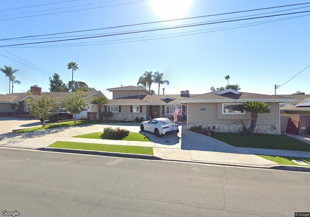
5603 Lancaster Dr Unit 10 San Diego, CA 92120
Del Cerro NeighborhoodEstimated Value: $1,635,000 - $2,099,000
5
Beds
5
Baths
3,489
Sq Ft
$520/Sq Ft
Est. Value
About This Home
This home is located at 5603 Lancaster Dr Unit 10, San Diego, CA 92120 and is currently estimated at $1,813,991, approximately $519 per square foot. 5603 Lancaster Dr Unit 10 is a home located in San Diego County with nearby schools including Hearst Elementary School, Lewis Middle School, and Patrick Henry High School.
Ownership History
Date
Name
Owned For
Owner Type
Purchase Details
Closed on
Sep 29, 2022
Sold by
Fenelli Francine M
Bought by
Fenelli Family Trust and Fenelli
Current Estimated Value
Purchase Details
Closed on
Nov 8, 2018
Sold by
Fornaca Ronald J and Fornaca Frank M
Bought by
Fenelli Francine M
Purchase Details
Closed on
Jun 27, 2011
Sold by
Fornaca Frank M
Bought by
Fornaca Frank M
Purchase Details
Closed on
Jan 18, 2011
Sold by
Fornaca Frank M
Bought by
Fornaca Frank M
Purchase Details
Closed on
Jun 7, 1995
Sold by
Fornaca Frank M and Fornaca Mary A
Bought by
Fornaca Frank M and Fornaca Mary Ann
Create a Home Valuation Report for This Property
The Home Valuation Report is an in-depth analysis detailing your home's value as well as a comparison with similar homes in the area
Home Values in the Area
Average Home Value in this Area
Purchase History
| Date | Buyer | Sale Price | Title Company |
|---|---|---|---|
| Fenelli Family Trust | -- | None Listed On Document | |
| Fenelli Francine M | -- | None Available | |
| Fenelli Francine M | -- | None Available | |
| Fornaca Frank M | -- | None Available | |
| Fornaca Frank M | $53,500 | None Available | |
| Fornaca Frank M | -- | None Available | |
| Fornaca Frank M | -- | -- |
Source: Public Records
Tax History Compared to Growth
Tax History
| Year | Tax Paid | Tax Assessment Tax Assessment Total Assessment is a certain percentage of the fair market value that is determined by local assessors to be the total taxable value of land and additions on the property. | Land | Improvement |
|---|---|---|---|---|
| 2025 | $2,710 | $222,172 | $34,856 | $187,316 |
| 2024 | $2,710 | $217,817 | $34,173 | $183,644 |
| 2023 | $2,650 | $213,547 | $33,503 | $180,044 |
| 2022 | $2,579 | $209,361 | $32,847 | $176,514 |
| 2021 | $2,562 | $205,256 | $32,203 | $173,053 |
| 2020 | $2,531 | $203,152 | $31,873 | $171,279 |
| 2019 | $1,846 | $147,209 | $31,249 | $115,960 |
| 2018 | $1,645 | $144,324 | $30,637 | $113,687 |
| 2017 | $80 | $141,495 | $30,037 | $111,458 |
| 2016 | $1,576 | $138,722 | $29,449 | $109,273 |
| 2015 | $1,552 | $136,639 | $29,007 | $107,632 |
| 2014 | $1,527 | $133,963 | $28,439 | $105,524 |
Source: Public Records
Map
Nearby Homes
- 6543 Carthage St
- 5513 Adobe Falls Rd Unit 11
- 6016 Wenrich Place
- 5432 Adobe Falls Rd Unit 12
- 6549 Glenroy St
- 6183 Rockhurst Dr
- 6196 Rockhurst Dr
- 6817 Birchwood St
- 5996 College Ave
- 6391 Estrella Ave
- 6329 Caminito Estrellado
- 5957 Caminito de la Taza
- 6342 Lambda Dr
- 5468 Princess View Place
- 6182 Loukelton Cir
- 5701 Madra Ave
- 7137 Keighley St
- 6221 Brynwood Ct
- 5873 Madra Ave
- 5540 Lindo Paseo Unit 19
- 5591 Lancaster Dr
- 5619 Lancaster Dr
- 5577 Lancaster Dr
- 5635 Lancaster Dr
- 5803 Kent Place
- 5804 Kent Place
- 5626 Lancaster Dr
- 5563 Lancaster Dr
- 5651 Lancaster Dr
- 5572 Lancaster Dr
- 5648 Lancaster Dr
- 5817 Kent Place
- 5814 Kent Place
- 5835 Kent Place
- 5665 Lancaster Dr
- 5556 Lancaster Dr
- 5549 Lancaster Dr
- 5662 Lancaster Dr Unit 10
- 5845 Kent Place
- 5525 Cambria Ct