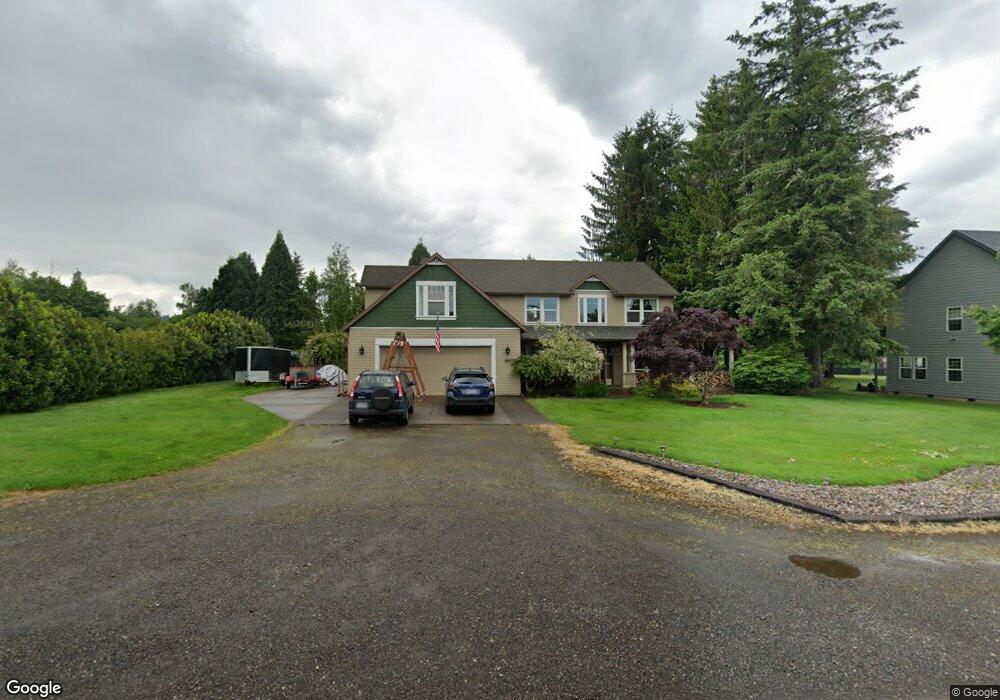
5604 SE 32nd St Gresham, OR 97080
Sandy River NeighborhoodEstimated Value: $821,000 - $905,000
5
Beds
3
Baths
3,860
Sq Ft
$223/Sq Ft
Est. Value
About This Home
This home is located at 5604 SE 32nd St, Gresham, OR 97080 and is currently estimated at $862,273, approximately $223 per square foot. 5604 SE 32nd St is a home located in Multnomah County with nearby schools including East Orient Elementary School, West Orient Middle School, and Sam Barlow High School.
Ownership History
Date
Name
Owned For
Owner Type
Purchase Details
Closed on
Sep 10, 2013
Sold by
Harding Philip A
Bought by
West Thomas P and West Heidi D
Current Estimated Value
Home Financials for this Owner
Home Financials are based on the most recent Mortgage that was taken out on this home.
Original Mortgage
$386,000
Outstanding Balance
$283,162
Interest Rate
4.36%
Mortgage Type
New Conventional
Estimated Equity
$579,111
Create a Home Valuation Report for This Property
The Home Valuation Report is an in-depth analysis detailing your home's value as well as a comparison with similar homes in the area
Home Values in the Area
Average Home Value in this Area
Purchase History
We collect this data history from publicly available records. To have your information removed, we recommend requesting removal directly through your county’s website.
| Date | Buyer | Sale Price | Title Company |
|---|---|---|---|
| West Thomas P | $482,500 | First American |
Source: Public Records
Mortgage History
We collect this data history from publicly available records. To have your information removed, we recommend requesting removal directly through your county’s website.
| Date | Status | Borrower | Loan Amount |
|---|---|---|---|
| Open | West Thomas P | $386,000 |
Source: Public Records
Tax History
| Year | Tax Paid | Tax Assessment Tax Assessment Total Assessment is a certain percentage of the fair market value that is determined by local assessors to be the total taxable value of land and additions on the property. | Land | Improvement |
|---|---|---|---|---|
| 2025 | $9,540 | $468,820 | -- | -- |
| 2024 | $9,132 | $455,170 | -- | -- |
| 2023 | $8,320 | $441,920 | $0 | $0 |
| 2022 | $8,088 | $429,050 | $0 | $0 |
| 2021 | $7,884 | $416,560 | $0 | $0 |
| 2020 | $7,418 | $404,430 | $0 | $0 |
| 2019 | $7,224 | $392,660 | $0 | $0 |
| 2018 | $6,888 | $381,230 | $0 | $0 |
| 2017 | $661 | $370,130 | $0 | $0 |
| 2016 | $5,827 | $359,350 | $0 | $0 |
| 2015 | $5,701 | $348,890 | $0 | $0 |
Source: Public Records
Map
Nearby Homes
- 5995 SE 33rd St
- 28131 SE Orient Dr
- 6366 SE 33rd Way
- 27238 SE Carl St
- 4505 SE 33rd Ct
- 4632 SE 28th Terrace
- 4747 SE Chase Rd
- 2728 SE Acacia Place
- 2600 SE Orient Dr
- 6448 SE 22nd St
- 6421 SE 22nd St
- 1878 SE Jasmine Place
- 5278 SE 18th St
- 5797 SE 18th Ct
- 1921 SE Douglas Place
- 7830 SE 267th Ave
- 2644 SE Paloma Terrace
- 4340 SE 22nd Dr
- 5827 SE 16th Loop
- 6106 SE 16th St
- 5556 SE 32nd St
- 0 SE 32nd St
- 3192 SE Kingfisher Ave
- 5742 SE 32nd St
- 3174 SE Kingfisher Ave
- 5657 SE 32nd St
- 5657 SE 32 Nd St
- 5577 SE 32nd St
- 3162 SE Kingfisher Ave
- 5500 SE 32nd St
- 5681 SE 32 Nd St
- 3233 SE Virginia Ave
- 5710 SE 32nd St
- 3148 SE Kingfisher Ave
- 5786 SE 32nd St
- 3167 SE Kingfisher Ave
- 5682 SE 31st Terrace
- 3135 SE Virginia Ave
- 5529 SE 32nd St
- 3130 SE Kingfisher Ave
Your Personal Tour Guide
Ask me questions while you tour the home.