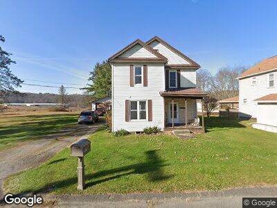
561 Myrtle St Reynoldsville, PA 15851
Estimated Value: $76,000 - $106,000
--
Bed
--
Bath
621
Sq Ft
$146/Sq Ft
Est. Value
About This Home
This home is located at 561 Myrtle St, Reynoldsville, PA 15851 and is currently estimated at $90,478, approximately $145 per square foot. 561 Myrtle St is a home located in Jefferson County with nearby schools including DuBois Area Senior High School and Soldier Christian Academy.
Ownership History
Date
Name
Owned For
Owner Type
Purchase Details
Closed on
Jun 10, 2019
Sold by
Maze Deborah A
Bought by
Mock James E and Mock Lori L
Current Estimated Value
Home Financials for this Owner
Home Financials are based on the most recent Mortgage that was taken out on this home.
Original Mortgage
$53,535
Interest Rate
3.8%
Mortgage Type
VA
Purchase Details
Closed on
Jun 10, 2009
Sold by
Maze John H and Maze Deborah A
Bought by
Maze Deborah A
Create a Home Valuation Report for This Property
The Home Valuation Report is an in-depth analysis detailing your home's value as well as a comparison with similar homes in the area
Home Values in the Area
Average Home Value in this Area
Purchase History
| Date | Buyer | Sale Price | Title Company |
|---|---|---|---|
| Mock James E | $53,000 | Entitle Insurance Company | |
| Maze Deborah A | -- | None Available |
Source: Public Records
Mortgage History
| Date | Status | Borrower | Loan Amount |
|---|---|---|---|
| Previous Owner | Mock James E | $53,535 |
Source: Public Records
Tax History Compared to Growth
Tax History
| Year | Tax Paid | Tax Assessment Tax Assessment Total Assessment is a certain percentage of the fair market value that is determined by local assessors to be the total taxable value of land and additions on the property. | Land | Improvement |
|---|---|---|---|---|
| 2024 | $1,433 | $25,970 | $7,470 | $18,500 |
| 2023 | $1,353 | $25,970 | $7,470 | $18,500 |
| 2022 | $1,368 | $25,970 | $7,470 | $18,500 |
| 2021 | $1,356 | $25,970 | $7,470 | $18,500 |
| 2020 | $1,367 | $25,970 | $7,470 | $18,500 |
| 2019 | $1,342 | $25,970 | $7,470 | $18,500 |
| 2018 | $1,334 | $25,970 | $7,470 | $18,500 |
| 2017 | $1,331 | $25,970 | $7,470 | $18,500 |
| 2016 | $1,291 | $25,970 | $7,470 | $18,500 |
| 2015 | -- | $25,970 | $7,470 | $18,500 |
| 2012 | -- | $25,970 | $7,470 | $18,500 |
Source: Public Records
Map
Nearby Homes
- 1185 Gordon Alley
- 407 Grant St
- 101 Brown St
- LOT 1 E Main & 11th St
- 820 Wayne Rd
- 1419 Burning Gas Well Rd
- 0 Stone House Rd
- 12310 Route 322
- 0 Turkey Ridge Rd Lot 4
- 3620 Fuller Rd
- 220 Turkey Ridge Rd
- 00 Fuller Rd
- 26 Paradise Rd
- 18 Paradise Rd
- 201 W Main St
- 0 Old Woods Rd
- 178 Summit Rd
- 865 Kyle Run Rd
- 296 Thunderbird Rd
- 00 Ishman Rd