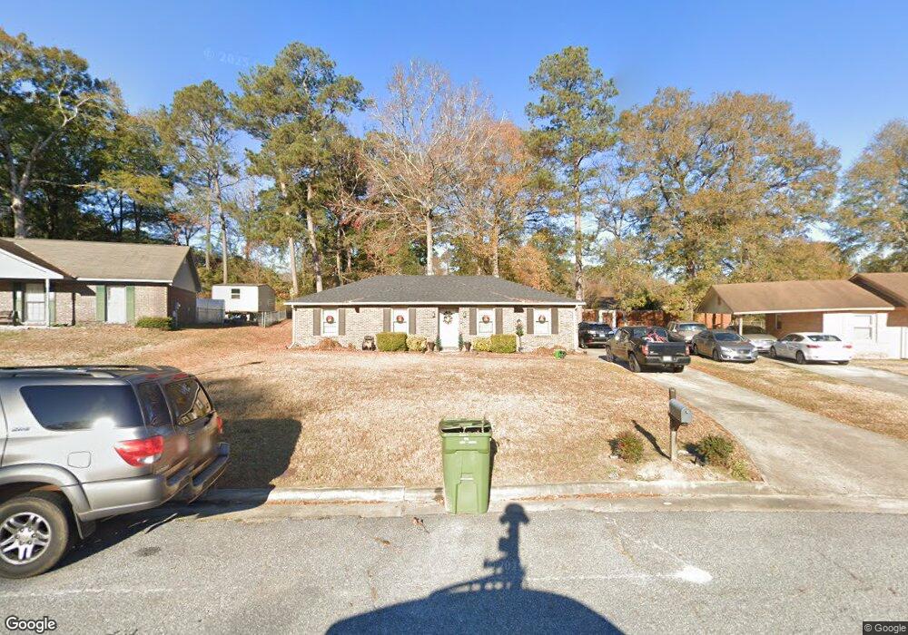
5633 Lexington Dr Columbus, GA 31907
Eastern Columbus NeighborhoodEstimated Value: $170,000 - $191,085
3
Beds
3
Baths
1,689
Sq Ft
$107/Sq Ft
Est. Value
About This Home
This home is located at 5633 Lexington Dr, Columbus, GA 31907 and is currently estimated at $180,521, approximately $106 per square foot. 5633 Lexington Dr is a home located in Muscogee County with nearby schools including Dawson Elementary School, East Columbus Magnet Academy, and Spencer High School.
Ownership History
Date
Name
Owned For
Owner Type
Purchase Details
Closed on
Jan 9, 2009
Sold by
Countrywide Home Loans Inc
Bought by
Phillips Melanie C
Current Estimated Value
Home Financials for this Owner
Home Financials are based on the most recent Mortgage that was taken out on this home.
Original Mortgage
$87,742
Outstanding Balance
$56,343
Interest Rate
5.48%
Mortgage Type
FHA
Estimated Equity
$124,178
Purchase Details
Closed on
May 6, 2008
Sold by
Williams Seneca P
Bought by
Countrywide Home Loans Inc
Create a Home Valuation Report for This Property
The Home Valuation Report is an in-depth analysis detailing your home's value as well as a comparison with similar homes in the area
Home Values in the Area
Average Home Value in this Area
Purchase History
| Date | Buyer | Sale Price | Title Company |
|---|---|---|---|
| Phillips Melanie C | $88,900 | None Available | |
| Countrywide Home Loans Inc | $106,500 | None Available |
Source: Public Records
Mortgage History
| Date | Status | Borrower | Loan Amount |
|---|---|---|---|
| Open | Phillips Melanie C | $87,742 |
Source: Public Records
Tax History Compared to Growth
Tax History
| Year | Tax Paid | Tax Assessment Tax Assessment Total Assessment is a certain percentage of the fair market value that is determined by local assessors to be the total taxable value of land and additions on the property. | Land | Improvement |
|---|---|---|---|---|
| 2025 | $1,543 | $61,248 | $13,312 | $47,936 |
| 2024 | $1,542 | $61,248 | $13,312 | $47,936 |
| 2023 | $858 | $61,248 | $13,312 | $47,936 |
| 2022 | $1,608 | $44,816 | $13,312 | $31,504 |
| 2021 | $1,601 | $41,232 | $13,312 | $27,920 |
| 2020 | $1,602 | $41,232 | $13,312 | $27,920 |
| 2019 | $1,609 | $41,232 | $13,312 | $27,920 |
| 2018 | $1,609 | $41,232 | $13,312 | $27,920 |
| 2017 | $1,616 | $41,232 | $13,312 | $27,920 |
| 2016 | $1,623 | $52,612 | $6,160 | $46,452 |
| 2015 | $1,625 | $52,612 | $6,160 | $46,452 |
| 2014 | $1,546 | $50,635 | $6,160 | $44,475 |
| 2013 | -- | $50,635 | $6,160 | $44,475 |
Source: Public Records
Map
Nearby Homes
- 5644 Quebec Dr
- 5613 Quebec Dr
- 5728 Lexington Dr
- 5664 St Marys Rd
- 1340 Bunker Ridge Ln
- 5310 Stoney Point Rd
- 1238 Brandywine Dr
- 1513 Alamo Dr
- 4462 Walking Stick Way
- 1210 Bunker Hill Rd
- 5336 Gettysburg Way
- 5219 Argonne Dr
- 5090 Lexington Ln
- 5109 Lexington Ln
- 4408 Walking Stick Way
- 849 Bunker Hill Rd
- 780 Honey Do Ct
- 4939 Aaron Dr
- 1025 Belmar St
- 1225 Rowell St
- 5629 Lexington Dr
- 5637 Lexington Dr
- 5618 Quebec Dr
- 5624 Quebec Dr
- 5625 Lexington Dr
- 5643 Lexington Dr
- 5612 Quebec Dr
- 5632 Quebec Dr
- 1717 Bunker Hill Rd
- 5636 Lexington Dr
- 5626 Lexington Dr
- 1709 Bunker Hill Rd
- 5617 Lexington Dr
- 5638 Quebec Dr
- 5600 Quebec Dr
- 5649 Lexington Dr
- 1693 Breeds Hill Loop
- 5618 Lexington Dr
- 1701 Bunker Hill Rd
- 1511 Breeds Hill Loop