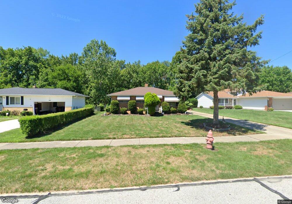
5636 Lori Dr Bedford, OH 44146
Estimated Value: $170,000 - $190,000
2
Beds
2
Baths
1,170
Sq Ft
$155/Sq Ft
Est. Value
About This Home
This home is located at 5636 Lori Dr, Bedford, OH 44146 and is currently estimated at $181,168, approximately $154 per square foot. 5636 Lori Dr is a home located in Cuyahoga County with nearby schools including Heskett Middle School, Bedford High School, and Ohio College Preparatory School.
Ownership History
Date
Name
Owned For
Owner Type
Purchase Details
Closed on
Aug 13, 2021
Sold by
Estate Of Edward Cunningham
Bought by
Cunningham Betty J
Current Estimated Value
Home Financials for this Owner
Home Financials are based on the most recent Mortgage that was taken out on this home.
Original Mortgage
$102,500
Outstanding Balance
$91,675
Interest Rate
2.7%
Mortgage Type
Future Advance Clause Open End Mortgage
Estimated Equity
$89,493
Purchase Details
Closed on
Apr 23, 1990
Sold by
Plater Philip
Bought by
Cunningham Edward
Purchase Details
Closed on
Dec 15, 1989
Sold by
Plater Philip and Plater Icie
Bought by
Plater Philip
Purchase Details
Closed on
Sep 4, 1985
Sold by
Hirchak Leonard A
Bought by
Plater Philip and Plater Icie
Purchase Details
Closed on
Apr 17, 1984
Sold by
Hirchak Leonard A and L H
Bought by
Hirchak Leonard A
Purchase Details
Closed on
Jan 1, 1975
Bought by
Hirchak Leonard A and L H
Create a Home Valuation Report for This Property
The Home Valuation Report is an in-depth analysis detailing your home's value as well as a comparison with similar homes in the area
Home Values in the Area
Average Home Value in this Area
Purchase History
| Date | Buyer | Sale Price | Title Company |
|---|---|---|---|
| Cunningham Betty J | -- | None Available | |
| Cunningham Edward | $78,000 | -- | |
| Plater Philip | -- | -- | |
| Plater Philip | $68,000 | -- | |
| Hirchak Leonard A | -- | -- | |
| Hirchak Leonard A | -- | -- |
Source: Public Records
Mortgage History
| Date | Status | Borrower | Loan Amount |
|---|---|---|---|
| Open | Cunningham Betty J | $102,500 |
Source: Public Records
Tax History
| Year | Tax Paid | Tax Assessment Tax Assessment Total Assessment is a certain percentage of the fair market value that is determined by local assessors to be the total taxable value of land and additions on the property. | Land | Improvement |
|---|---|---|---|---|
| 2025 | $4,208 | $59,045 | $9,275 | $49,770 |
| 2024 | $4,208 | $59,045 | $9,275 | $49,770 |
| 2023 | $3,967 | $48,170 | $9,350 | $38,820 |
| 2022 | $3,468 | $48,160 | $9,350 | $38,820 |
| 2021 | $3,431 | $48,160 | $9,350 | $38,820 |
| 2020 | $3,127 | $39,480 | $7,670 | $31,820 |
| 2019 | $3,035 | $112,800 | $21,900 | $90,900 |
| 2018 | $3,018 | $39,480 | $7,670 | $31,820 |
| 2017 | $3,014 | $37,250 | $5,990 | $31,260 |
| 2016 | $2,990 | $37,250 | $5,990 | $31,260 |
| 2015 | $2,985 | $37,250 | $5,990 | $31,260 |
| 2014 | $2,985 | $37,250 | $5,990 | $31,260 |
Source: Public Records
Map
Nearby Homes
- 5696 Columbia Dr
- 23100 Rockside Rd
- 23781 Columbus Rd
- 24051 Columbus Rd
- 5731 Meadow Ln
- 5437 Bartlett Rd
- 682 Archer Rd
- 5385 Bartlett Rd
- 5424 Fairtree Rd
- 840 Archer Rd
- 541 Helper Dr
- 733 High St
- 25150 Columbus Rd
- 5301 Mardale Ave
- 24419 Ronan Rd
- 5285 Mardale Ave
- 24570 Staghorn Dr
- 263 Columbus St
- 61 Hubbell Way
- 57 Hubbell Way
Your Personal Tour Guide
Ask me questions while you tour the home.