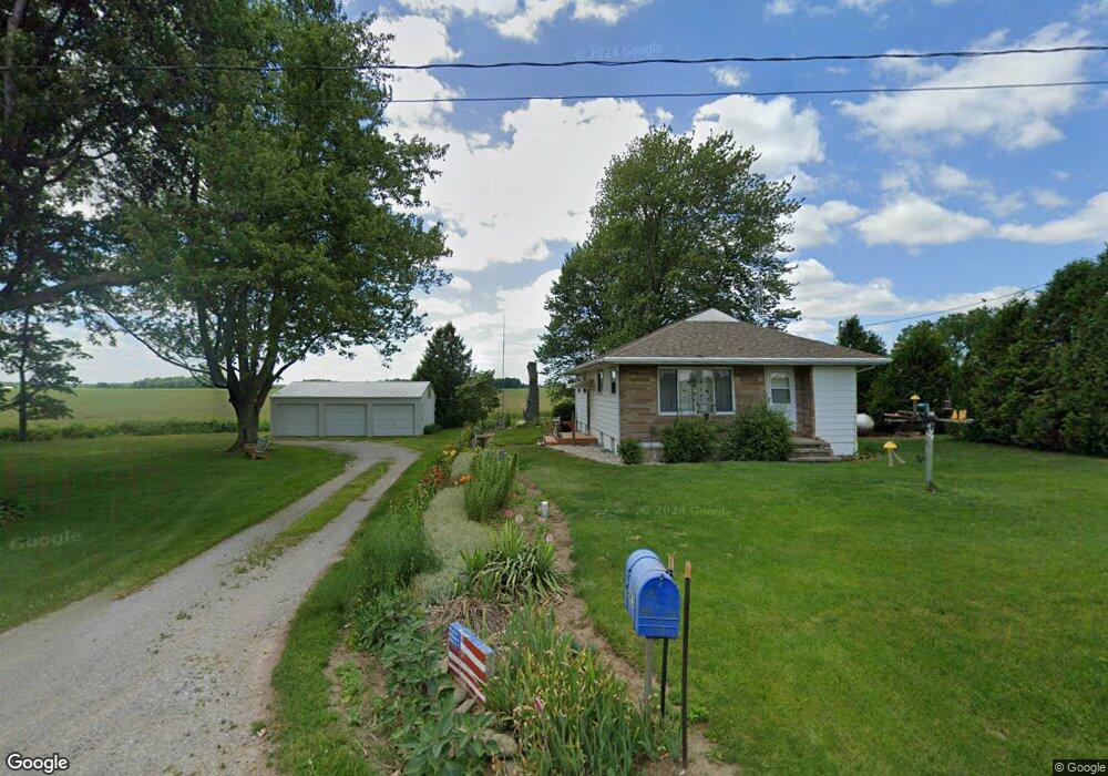
5643 County Road 10 Wauseon, OH 43567
Estimated Value: $117,000 - $182,000
3
Beds
1
Bath
1,060
Sq Ft
$138/Sq Ft
Est. Value
About This Home
This home is located at 5643 County Road 10, Wauseon, OH 43567 and is currently estimated at $146,598, approximately $138 per square foot. 5643 County Road 10 is a home located in Fulton County with nearby schools including Delta Elementary School, Pike-Delta-York Middle School, and Pike-Delta-York High School.
Ownership History
Date
Name
Owned For
Owner Type
Purchase Details
Closed on
May 17, 2021
Sold by
Ford Karen and Ford Harold L
Bought by
Finnerty Patty
Current Estimated Value
Purchase Details
Closed on
Jun 17, 2020
Sold by
Zolman Steve and Zolman Tarilynn
Bought by
Finnerty Patty
Purchase Details
Closed on
Jun 17, 2019
Sold by
Denton Barbara and Zolman Steve
Bought by
Finnerty Patty
Home Financials for this Owner
Home Financials are based on the most recent Mortgage that was taken out on this home.
Original Mortgage
$43,400
Interest Rate
4.1%
Mortgage Type
Purchase Money Mortgage
Purchase Details
Closed on
Jan 1, 1990
Bought by
Zolman Treva M
Create a Home Valuation Report for This Property
The Home Valuation Report is an in-depth analysis detailing your home's value as well as a comparison with similar homes in the area
Home Values in the Area
Average Home Value in this Area
Purchase History
| Date | Buyer | Sale Price | Title Company |
|---|---|---|---|
| Finnerty Patty | -- | None Available | |
| Finnerty Patty | -- | None Available | |
| Finnerty Patty | $53,600 | None Available | |
| Zolman Treva M | -- | -- |
Source: Public Records
Mortgage History
| Date | Status | Borrower | Loan Amount |
|---|---|---|---|
| Previous Owner | Finnerty Patty | $43,400 |
Source: Public Records
Tax History Compared to Growth
Tax History
| Year | Tax Paid | Tax Assessment Tax Assessment Total Assessment is a certain percentage of the fair market value that is determined by local assessors to be the total taxable value of land and additions on the property. | Land | Improvement |
|---|---|---|---|---|
| 2024 | $1,250 | $32,240 | $8,960 | $23,280 |
| 2023 | $1,254 | $32,240 | $8,960 | $23,280 |
| 2022 | $1,307 | $26,080 | $7,460 | $18,620 |
| 2021 | $1,365 | $26,080 | $7,460 | $18,620 |
| 2020 | $1,341 | $26,080 | $7,460 | $18,620 |
| 2019 | $1,176 | $23,460 | $7,320 | $16,140 |
| 2018 | $609 | $23,460 | $7,320 | $16,140 |
| 2017 | $1,196 | $23,460 | $7,320 | $16,140 |
| 2016 | $1,122 | $21,990 | $7,320 | $14,670 |
| 2015 | $1,049 | $21,990 | $7,320 | $14,670 |
| 2014 | $1,048 | $21,990 | $7,320 | $14,670 |
| 2013 | $1,115 | $23,100 | $8,050 | $15,050 |
Source: Public Records
Map
Nearby Homes
- 7373 County Road 12
- 7620 County Road 12
- 2872 County Road 11
- 421 Providence St
- 207 Wood St
- 308 Monroe St
- 518 Providence St
- 1090 Seneca Dr
- 413 Fernwood St
- 1058 Seneca Dr
- 1066 Seneca Dr
- 1062 Seneca Dr
- Integrity 1830 Plan at Arrowhead Trails
- integrity 2280 Plan at Arrowhead Trails
- Integrity 2080 Plan at Arrowhead Trails
- 305 Mckinley St
- 701 Palmwood St
- 1209 Apache Dr
- 703 Linwood Ave
- 13242 Us Highway 20a
- 5598 County Road 10
- 5723 County Road 10
- 5510 County Road 10
- 5835 County Road 10
- 5859 County Road 10
- 5889 County Road 10
- 5901 County Road 10
- 5423 County Road 10
- 10035 County Road F
- 10079 County Road F
- 10165 County Road F
- 9819 County Road F
- 10349 County Road F
- 9678 County Road F
- 10426 County Road F
- 10056 County Road E Unit 18-1
- 9502 County Road F
- 0 Co Rd E Lot 2
- 0
- 9451 County Road F