Estimated Value: $312,924 - $337,000
3
Beds
2
Baths
1,622
Sq Ft
$199/Sq Ft
Est. Value
About This Home
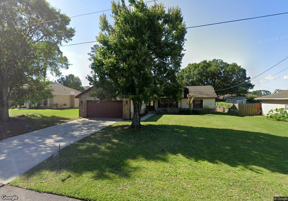
This home is located at 5645 Datura St, Cocoa, FL 32927 and is currently estimated at $321,981, approximately $198 per square foot. 5645 Datura St is a home located in Brevard County with nearby schools including Enterprise Elementary School, Space Coast Junior/Senior High School, and East Atlantic Prep of Brevard County.
Ownership History
Date
Name
Owned For
Owner Type
Purchase Details
Closed on
May 13, 2022
Sold by
Louise Weston Georgia
Bought by
Georgia Louise Weston Revocable Living Trust
Current Estimated Value
Purchase Details
Closed on
Sep 10, 2019
Sold by
Weston Timothy Martin and Weston Marcy Dawn
Bought by
Weston Georgia Louise
Purchase Details
Closed on
Sep 26, 2018
Sold by
Weston Georgia L
Bought by
Weston Timothy Martin
Create a Home Valuation Report for This Property
The Home Valuation Report is an in-depth analysis detailing your home's value as well as a comparison with similar homes in the area
Home Values in the Area
Average Home Value in this Area
Purchase History
| Date | Buyer | Sale Price | Title Company |
|---|---|---|---|
| Georgia Louise Weston Revocable Living Trust | -- | None Listed On Document | |
| Weston Georgia Louise | -- | Attorney | |
| Weston Georgia Louise | -- | Attorney | |
| Weston Timothy Martin | -- | None Available |
Source: Public Records
Tax History
| Year | Tax Paid | Tax Assessment Tax Assessment Total Assessment is a certain percentage of the fair market value that is determined by local assessors to be the total taxable value of land and additions on the property. | Land | Improvement |
|---|---|---|---|---|
| 2025 | $1,132 | $93,550 | -- | -- |
| 2024 | $1,097 | $90,920 | -- | -- |
| 2023 | $1,097 | $88,280 | $0 | $0 |
| 2022 | $1,055 | $85,710 | $0 | $0 |
| 2021 | $1,043 | $83,220 | $0 | $0 |
| 2020 | $979 | $82,080 | $0 | $0 |
| 2019 | $915 | $80,240 | $0 | $0 |
| 2018 | $908 | $78,750 | $0 | $0 |
| 2017 | $896 | $77,140 | $0 | $0 |
| 2016 | $894 | $75,560 | $18,000 | $57,560 |
| 2015 | $897 | $75,040 | $15,000 | $60,040 |
| 2014 | $898 | $74,450 | $11,000 | $63,450 |
Source: Public Records
Map
Nearby Homes
- 7200 Oakwood Ave
- 5680 Brandon St
- 5555 Brandon St
- 7065 Hundred Acre Dr
- 7230 Venus Ave
- 6990 Bryant Rd
- 7735 Fringe Place
- 7635 Fringe Place
- 7419 Hackberry Rd
- 5551 Cinnamon Fern Blvd
- 7429 Hackberry Rd
- 7368 Crepe Myrtle Ct
- 7606 Fringe Place
- 6815 Bryant Rd
- 6643 Emil Ave
- 5165 Patricia St
- 5155 Mayflower St
- 6760 Cairo Rd
- 5303 Yaupon Holly Dr
- 6615 Dock Ave
Your Personal Tour Guide
Ask me questions while you tour the home.