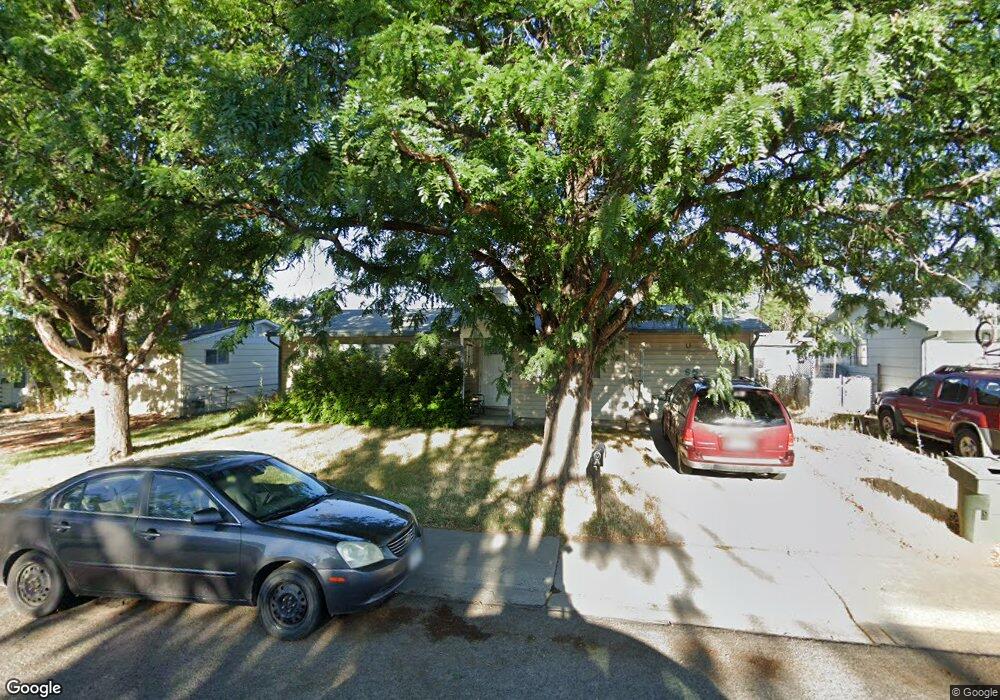
565 Cindy Ann Rd Grand Junction, CO 81501
Downtown Grand Junction NeighborhoodEstimated Value: $271,967 - $290,000
3
Beds
1
Bath
1,014
Sq Ft
$280/Sq Ft
Est. Value
About This Home
This home is located at 565 Cindy Ann Rd, Grand Junction, CO 81501 and is currently estimated at $283,992, approximately $280 per square foot. 565 Cindy Ann Rd is a home located in Mesa County with nearby schools including Orchard Avenue Elementary School, Bookcliff Middle School, and Central High School.
Ownership History
Date
Name
Owned For
Owner Type
Purchase Details
Closed on
Jun 10, 2016
Sold by
Sheldon Richard B and Sheldon Dianna L
Bought by
Sheldon Richard B and Sheldon Dianna L
Current Estimated Value
Purchase Details
Closed on
Mar 26, 2008
Sold by
Sheldon Richard B and Sheldon Dianna L
Bought by
Sheldon Richard B and Sheldon Dianna L
Purchase Details
Closed on
Sep 26, 2001
Sold by
Barreith William Albert
Bought by
Sheldon Richard B and Sheldon Dianna L
Home Financials for this Owner
Home Financials are based on the most recent Mortgage that was taken out on this home.
Original Mortgage
$81,910
Outstanding Balance
$32,039
Interest Rate
6.88%
Mortgage Type
FHA
Estimated Equity
$251,953
Purchase Details
Closed on
Jul 31, 2000
Sold by
Barreith Barbara and Barreith Barbara E
Bought by
Barreith William Albert
Create a Home Valuation Report for This Property
The Home Valuation Report is an in-depth analysis detailing your home's value as well as a comparison with similar homes in the area
Home Values in the Area
Average Home Value in this Area
Purchase History
| Date | Buyer | Sale Price | Title Company |
|---|---|---|---|
| Sheldon Richard B | -- | None Available | |
| Sheldon Richard B | -- | None Available | |
| Sheldon Richard B | $88,500 | Meridian Land Title Llc | |
| Barreith William Albert | -- | -- |
Source: Public Records
Mortgage History
| Date | Status | Borrower | Loan Amount |
|---|---|---|---|
| Open | Sheldon Richard B | $81,910 |
Source: Public Records
Tax History Compared to Growth
Tax History
| Year | Tax Paid | Tax Assessment Tax Assessment Total Assessment is a certain percentage of the fair market value that is determined by local assessors to be the total taxable value of land and additions on the property. | Land | Improvement |
|---|---|---|---|---|
| 2024 | $877 | $12,410 | $3,870 | $8,540 |
| 2023 | $877 | $12,410 | $3,870 | $8,540 |
| 2022 | $825 | $11,450 | $3,480 | $7,970 |
| 2021 | $828 | $11,780 | $3,580 | $8,200 |
| 2020 | $676 | $9,840 | $3,220 | $6,620 |
| 2019 | $639 | $9,840 | $3,220 | $6,620 |
| 2018 | $617 | $8,660 | $3,240 | $5,420 |
| 2017 | $544 | $8,660 | $3,240 | $5,420 |
| 2016 | $544 | $8,610 | $3,180 | $5,430 |
| 2015 | $551 | $8,610 | $3,180 | $5,430 |
| 2014 | $454 | $7,150 | $2,790 | $4,360 |
Source: Public Records
Map
Nearby Homes
- 553 Princess St
- 2534 Bookcliff Ave
- 554 Princess St
- 1945 N 24th St
- TBD 28 1 4 Rd
- 575 28 1 4 Rd Unit 2
- 2115 N 24th St
- 2813 Columbine Park Ct
- 2604 Texas Ave
- 2312 Mesa Ave
- 2336 Elm Ave
- 2823 Elm Ave
- 2823 1/2 Elm Ave
- 575 28 1 2 Rd Unit 66
- 2836 Grand Falls Cir Unit A
- 2810 Bunting Ave
- 2450 Pheasant Trail Ct
- 2525 Pheasant Run Cir
- 1615 N 20th St
- 2305 Springside Ct