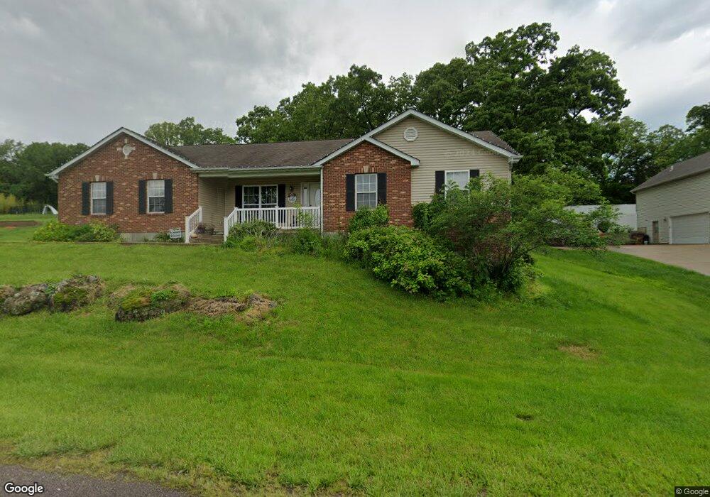
565 Rock Creek Dr Washington, MO 63090
Estimated Value: $314,475 - $406,000
3
Beds
3
Baths
1,460
Sq Ft
$255/Sq Ft
Est. Value
About This Home
This home is located at 565 Rock Creek Dr, Washington, MO 63090 and is currently estimated at $372,119, approximately $254 per square foot. 565 Rock Creek Dr is a home located in Franklin County with nearby schools including Washington High School, St. Gertrude Catholic School, and Immaculate Conception School.
Ownership History
Date
Name
Owned For
Owner Type
Purchase Details
Closed on
Feb 13, 2023
Sold by
Lough Dan and Lough Karen Y
Bought by
Lough David Z and Lough Sarah M
Current Estimated Value
Purchase Details
Closed on
Aug 26, 2009
Sold by
Deutsche Bank National Trust Company
Bought by
Lough Dan and Lough Karen Y
Home Financials for this Owner
Home Financials are based on the most recent Mortgage that was taken out on this home.
Original Mortgage
$140,000
Interest Rate
5.16%
Mortgage Type
New Conventional
Purchase Details
Closed on
Jun 11, 2009
Sold by
Mitchell Christopher W and Mitchell Kathleen D
Bought by
Deutsche Bank National Trust Co and Morgan Stanley Abs Capital Inc
Create a Home Valuation Report for This Property
The Home Valuation Report is an in-depth analysis detailing your home's value as well as a comparison with similar homes in the area
Home Values in the Area
Average Home Value in this Area
Purchase History
| Date | Buyer | Sale Price | Title Company |
|---|---|---|---|
| Lough David Z | -- | -- | |
| Lough Dan | -- | Mokan Title Services | |
| Deutsche Bank National Trust Co | $170,000 | None Available |
Source: Public Records
Mortgage History
| Date | Status | Borrower | Loan Amount |
|---|---|---|---|
| Previous Owner | Lough Dan | $140,000 |
Source: Public Records
Tax History Compared to Growth
Tax History
| Year | Tax Paid | Tax Assessment Tax Assessment Total Assessment is a certain percentage of the fair market value that is determined by local assessors to be the total taxable value of land and additions on the property. | Land | Improvement |
|---|---|---|---|---|
| 2024 | $1,870 | $33,755 | $0 | $0 |
| 2023 | $1,870 | $33,755 | $0 | $0 |
| 2022 | $2,048 | $36,875 | $0 | $0 |
| 2021 | $2,048 | $36,875 | $0 | $0 |
| 2020 | $2,038 | $35,298 | $0 | $0 |
| 2019 | $2,030 | $35,298 | $0 | $0 |
| 2018 | $1,759 | $32,197 | $0 | $0 |
| 2017 | $1,763 | $32,197 | $0 | $0 |
| 2016 | $1,640 | $29,790 | $0 | $0 |
| 2015 | $1,639 | $29,790 | $0 | $0 |
| 2014 | $1,658 | $30,138 | $0 | $0 |
Source: Public Records
Map
Nearby Homes
- 541 Rock Creek Dr
- 186 Little Rock Creek Ct
- 613 Rock Creek Dr
- 406 Mark Twain Loop
- 405 Mark Twain Loop
- 443 Mark Twain Loop
- 873 W Park Rd
- 430 Mark Twain Loop
- 21 Forest Ln
- 33 Hickory Cir
- 54 Hickory Cir
- 89 Hickory Cir
- 101 Hickory Cir
- 513 Sawgrass Ct
- 2073 Hickory Ridge Rd
- 2872 Highway A
- 7290 Highway Bb
- 7040 Highway Yy
- 952 Brookline Dr
- 2 Tanya Ln
- 553 Rock Creek Dr
- 571 Rock Creek Dr
- 570 Rock Creek Dr
- 566 Rock Creek Dr
- 566 Rock Creek Dr
- 579 Rock Creek Dr
- 578 Rock Creek Dr
- 554 Rock Creek Dr
- 6560 Highway Bb
- 547 Rock Creek Dr
- 6630 Highway Bb
- 584 Rock Creek Dr
- 6640 Highway Bb
- 585 Rock Creek Dr
- 291 Amber Ridge Dr
- 297 Amber Ridge Dr
- 286 Amber Ridge Dr
- 292 Amber Ridge Dr
- 534 Rock Creek Dr
- 6644 Highway Bb