Estimated Value: $331,253 - $404,000
3
Beds
2
Baths
2,148
Sq Ft
$175/Sq Ft
Est. Value
About This Home
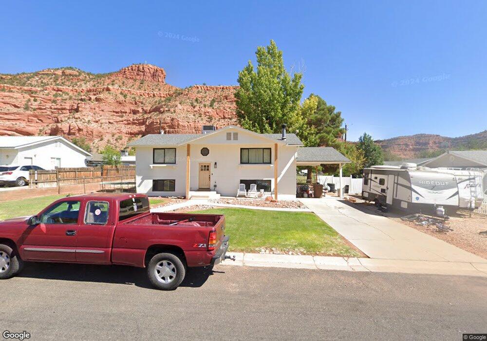
This home is located at 566 N 100 E, Kanab, UT 84741 and is currently estimated at $375,063, approximately $174 per square foot. 566 N 100 E is a home located in Kane County with nearby schools including Kanab Elementary School, Kanab Middle School, and Kanab High School.
Ownership History
Date
Name
Owned For
Owner Type
Purchase Details
Closed on
Oct 20, 2020
Sold by
Singleton Shayne D
Bought by
Glover Sterling
Current Estimated Value
Purchase Details
Closed on
Dec 16, 2015
Sold by
Brian King and Brian Shaina
Bought by
Grymes Kevin
Purchase Details
Closed on
Aug 4, 2014
Sold by
Ocwen Loan Servicing Llc
Bought by
King Brian and King Shaina
Purchase Details
Closed on
Apr 10, 2014
Sold by
Halliday Paul M
Bought by
Us Bank National Association and Mastr Asset Backed Securities Trust 2006
Purchase Details
Closed on
Nov 26, 2007
Sold by
Household Finance Corporation Iii
Bought by
Richer Arnold
Create a Home Valuation Report for This Property
The Home Valuation Report is an in-depth analysis detailing your home's value as well as a comparison with similar homes in the area
Home Values in the Area
Average Home Value in this Area
Purchase History
| Date | Buyer | Sale Price | Title Company |
|---|---|---|---|
| Glover Sterling | -- | -- | |
| Grymes Kevin | -- | -- | |
| King Brian | -- | -- | |
| Us Bank National Association | -- | -- | |
| Richer Arnold | -- | -- |
Source: Public Records
Tax History
| Year | Tax Paid | Tax Assessment Tax Assessment Total Assessment is a certain percentage of the fair market value that is determined by local assessors to be the total taxable value of land and additions on the property. | Land | Improvement |
|---|---|---|---|---|
| 2025 | $1,689 | $357,985 | $93,172 | $264,813 |
| 2024 | $1,776 | $206,352 | $46,164 | $160,188 |
| 2023 | $1,592 | $189,591 | $43,965 | $145,626 |
| 2022 | $1,410 | $166,207 | $33,820 | $132,387 |
| 2021 | $1,275 | $225,599 | $47,300 | $178,299 |
| 2020 | $1,233 | $211,880 | $43,000 | $168,880 |
| 2019 | $1,125 | $188,215 | $43,296 | $144,919 |
| 2018 | $1,091 | $180,999 | $36,080 | $144,919 |
| 2017 | $1,038 | $164,440 | $32,800 | $131,640 |
| 2016 | $927 | $142,586 | $32,800 | $109,786 |
| 2015 | $880 | $146,096 | $32,800 | $113,296 |
| 2014 | $880 | $134,589 | $35,128 | $99,461 |
| 2013 | -- | $74,023 | $0 | $0 |
Source: Public Records
Map
Nearby Homes
- 238 E 330 N
- 6 300 N
- 300 E 300 N
- 300 E 300 N Unit A3
- 300 E 300 N Unit A8
- 300 E 300 N Unit H6
- 320 W Los Barancos Ln
- 297 N 100 W
- 236 200
- 463 E Deadwood Dr
- 493 E Donner Cir
- 281 W Ladera Ln
- 61 W 200 N
- 484 E Mohawk Dr
- 190 W Ladera Ln
- Lot 353 Rain Maker Rd
- 639 Rain Maker Rd
- 587 E El Valle Dr
- 444 Ladera Ln
- 70 N Main St
Your Personal Tour Guide
Ask me questions while you tour the home.