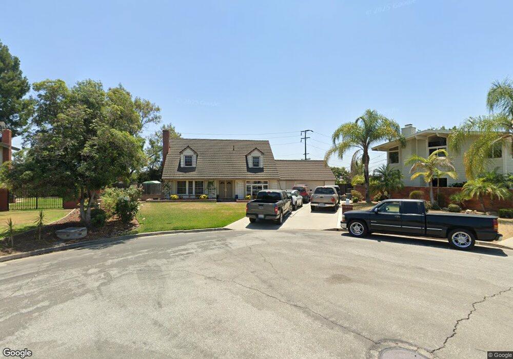
5661 Kenwood Ave Buena Park, CA 90621
Estimated Value: $1,222,000 - $1,459,000
4
Beds
3
Baths
2,611
Sq Ft
$513/Sq Ft
Est. Value
About This Home
This home is located at 5661 Kenwood Ave, Buena Park, CA 90621 and is currently estimated at $1,339,785, approximately $513 per square foot. 5661 Kenwood Ave is a home located in Orange County with nearby schools including Charles G. Emery Elementary School, Buena Park Junior High School, and Sunny Hills High School.
Ownership History
Date
Name
Owned For
Owner Type
Purchase Details
Closed on
May 11, 2021
Sold by
Johnson Marvin E and Johnson Carol D
Bought by
Johnson Marvin and Johnson Carol
Current Estimated Value
Purchase Details
Closed on
Sep 8, 1997
Sold by
Cromwell Timothy P and Cromwell Mary T
Bought by
Johnson Marvin E and Johnson Carol D
Home Financials for this Owner
Home Financials are based on the most recent Mortgage that was taken out on this home.
Original Mortgage
$214,600
Outstanding Balance
$33,169
Interest Rate
7.44%
Estimated Equity
$1,306,616
Create a Home Valuation Report for This Property
The Home Valuation Report is an in-depth analysis detailing your home's value as well as a comparison with similar homes in the area
Home Values in the Area
Average Home Value in this Area
Purchase History
| Date | Buyer | Sale Price | Title Company |
|---|---|---|---|
| Johnson Marvin | -- | None Available | |
| Johnson Marvin E | $270,000 | First American Title Ins Co |
Source: Public Records
Mortgage History
| Date | Status | Borrower | Loan Amount |
|---|---|---|---|
| Open | Johnson Marvin E | $214,600 |
Source: Public Records
Tax History Compared to Growth
Tax History
| Year | Tax Paid | Tax Assessment Tax Assessment Total Assessment is a certain percentage of the fair market value that is determined by local assessors to be the total taxable value of land and additions on the property. | Land | Improvement |
|---|---|---|---|---|
| 2025 | $4,884 | $431,115 | $258,360 | $172,755 |
| 2024 | $4,884 | $422,662 | $253,294 | $169,368 |
| 2023 | $4,783 | $414,375 | $248,327 | $166,048 |
| 2022 | $4,704 | $406,250 | $243,457 | $162,793 |
| 2021 | $4,668 | $398,285 | $238,684 | $159,601 |
| 2020 | $4,610 | $394,202 | $236,237 | $157,965 |
| 2019 | $4,500 | $386,473 | $231,605 | $154,868 |
| 2018 | $4,412 | $378,896 | $227,064 | $151,832 |
| 2017 | $4,349 | $371,467 | $222,612 | $148,855 |
| 2016 | $7,618 | $364,184 | $218,247 | $145,937 |
| 2015 | $7,444 | $358,714 | $214,969 | $143,745 |
| 2014 | $7,429 | $351,688 | $210,758 | $140,930 |
Source: Public Records
Map
Nearby Homes
- 8542 Emerywood Dr
- 9 Coveside Ct
- 65 Windward Way Unit 23
- 86 Lakeside Dr
- 11 Travis Rd
- 8237 Henshaw Cir
- 6 Tidewater Cove
- 5588 Cajon Ave
- 5412 Arrowhead Ave
- 5471 Jonesboro Way
- 5211 Fox Hills Ave
- 5941 Stanton Ave
- 4014 W Commonwealth Ave
- 101 Turner Ave
- 8244 Henderson Green
- 8325 Beethoven Dr
- 4900 Lincolnshire Ave
- 4840 Sunnybrook Ave
- 5822 Fullerton Ave
- 2523 Cypress Point Dr
- 5651 Kenwood Ave
- 8510 Links Rd
- 5662 Monticello Ave
- 5641 Kenwood Ave
- 5652 Monticello Ave
- 8532 Links Rd
- 5642 Monticello Ave
- 8511 Links Rd
- 5631 Kenwood Ave
- 5632 Monticello Ave
- 2 Coveside Ct
- 8531 Links Rd
- 8552 Links Rd
- 5621 Kenwood Ave
- 6 Coveside Ct Unit 53
- 1 Coveside Ct
- 8 Coveside Ct Unit 52
- 5622 Monticello Ave
- 5661 Monticello Ave
- 5651 Monticello Ave