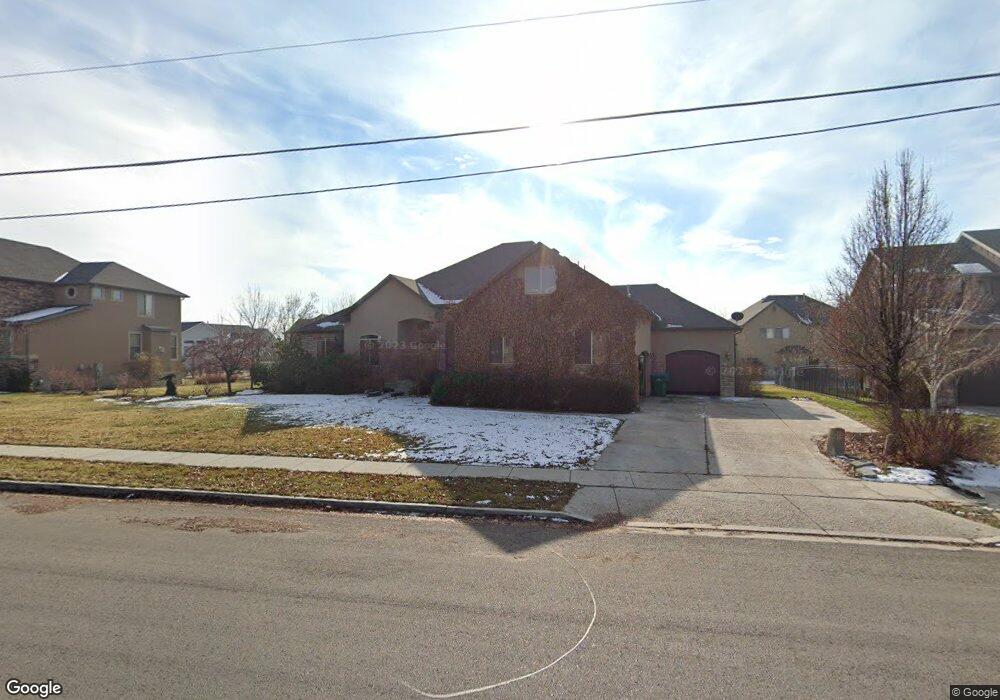
5669 W 9600 N Highland, UT 84003
Estimated Value: $832,000 - $1,521,000
4
Beds
3
Baths
5,279
Sq Ft
$217/Sq Ft
Est. Value
About This Home
This home is located at 5669 W 9600 N, Highland, UT 84003 and is currently estimated at $1,143,713, approximately $216 per square foot. 5669 W 9600 N is a home located in Utah County with nearby schools including Legacy Elementary School, American Fork Junior High School, and American Fork High School.
Ownership History
Date
Name
Owned For
Owner Type
Purchase Details
Closed on
Jul 18, 2023
Sold by
Denise Nydegger Trust
Bought by
Denise W Nydegger Trust and Rick D Nydegger Trust
Current Estimated Value
Purchase Details
Closed on
Sep 29, 2008
Sold by
Nydegger Rick D and Nydegger Denise W
Bought by
Nydegger Denise W
Purchase Details
Closed on
Sep 26, 2008
Sold by
Rasmussen Lynett and Rasmussen Wade
Bought by
Nydegger Rick D and Nydegger Denise W
Purchase Details
Closed on
Jul 13, 2007
Sold by
Hunter Cory
Bought by
Rasmussen Lynette and Rasmussen Wade
Home Financials for this Owner
Home Financials are based on the most recent Mortgage that was taken out on this home.
Original Mortgage
$586,500
Interest Rate
6.51%
Mortgage Type
Purchase Money Mortgage
Create a Home Valuation Report for This Property
The Home Valuation Report is an in-depth analysis detailing your home's value as well as a comparison with similar homes in the area
Home Values in the Area
Average Home Value in this Area
Purchase History
| Date | Buyer | Sale Price | Title Company |
|---|---|---|---|
| Denise W Nydegger Trust | -- | None Listed On Document | |
| Nydegger Denise W | -- | Highland Title | |
| Nydegger Rick D | -- | Highland Title | |
| Rasmussen Lynette | -- | First American Lindon |
Source: Public Records
Mortgage History
| Date | Status | Borrower | Loan Amount |
|---|---|---|---|
| Previous Owner | Rasmussen Lynette | $586,500 |
Source: Public Records
Tax History Compared to Growth
Tax History
| Year | Tax Paid | Tax Assessment Tax Assessment Total Assessment is a certain percentage of the fair market value that is determined by local assessors to be the total taxable value of land and additions on the property. | Land | Improvement |
|---|---|---|---|---|
| 2025 | $4,345 | $568,315 | $455,100 | $578,200 |
| 2024 | $4,345 | $536,745 | $0 | $0 |
| 2023 | $4,073 | $542,685 | $0 | $0 |
| 2022 | $3,809 | $492,085 | $0 | $0 |
| 2021 | $3,499 | $673,400 | $275,300 | $398,100 |
| 2020 | $3,316 | $625,900 | $239,400 | $386,500 |
| 2019 | $3,170 | $625,900 | $239,400 | $386,500 |
| 2018 | $268 | $594,400 | $228,500 | $365,900 |
| 2017 | $2,942 | $294,690 | $0 | $0 |
| 2016 | $3,199 | $299,420 | $0 | $0 |
| 2015 | $3,218 | $285,450 | $0 | $0 |
| 2014 | $3,003 | $264,055 | $0 | $0 |
Source: Public Records
Map
Nearby Homes
- 16 E 1400 N
- 35 W 1350 N
- 703 S 850 W
- 5423 W Pebble Ln
- 1201 N 160 E
- 9947 N Yorkshire Ct
- 9780 N 6000 W
- 179 W 1290 N
- 5973 W 9960 N
- 1071 Timpview Dr
- 287 W 1360 N
- 5586 W 10130 N
- 10197 N 5750 W
- 1271 E Desert Peak St
- 1247 E Desert Peak St
- 1793 E Kern Mountain
- McLean Farmhouse Plan at Ridgeview - Cottages
- McLean Farmhouse Plan at Ridgeview - Estates
- 356 W 1300 N
- 5378 W 10130 N